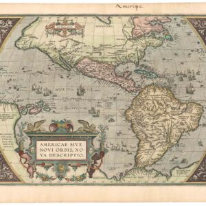
Sebastian Münster’s Map of the Americas: The first printed map of the new continents in their entirety. Here a rare First State, Second Edition example.
Novae Insulae XVII Nova Tabula [First State!]
Out of stock
Description
1. The earliest map to show North and South America in full continental form, Münster’s Novae Insulae is one of the most important and iconic maps of early America.
2. It is a map that gives us a window onto the Renaissance mind; the very title — “New Islands” — expresses how Europeans conceived of the New World in the 16th century.
3. Place names on the map provide us with a range of important insights into the way that Münster understood American geography at this stage.
4. With a prominent NW Passage and Sea of Verrazzano, a reliance on the accounts of Marco Polo, and demarcation of the Treaty of Tordesillas, many of the great cartographic themes of the era are all present on this one map.
Münster’s Americas is a map of firsts: it is the first printed map in history to depict the American continents in their full form; it is the first application of the term Mare Pacificum as a concrete designation; and it is one of the first European depictions of Japan and its associated archipelago (the first state was published three years before European ships first reached Japan). For decades after its initial publication, it was without doubt the most famous and most widely circulated map of the New World on the market. It was only gradually replaced from its thirty year dominance when Abraham Ortelius published his seminal map of America in 1570. These elements make it one of the most desirable and collectible maps on the market, a linchpin in any collection with a focus on America.
The most striking feature of Münster’s map of the New World is perhaps the huge bay that scoops into the heart of North America, nearly dividing it into two separate landmasses (labeled FRANCISCA and Terre florida, respectively). This bay represents the so-called ‘Verrazzano Sea,’ an enduring concept based on reports from Florentine explorer Giovanni da Verrazzano’s 1524 voyage to the Americas. Verrazzano is famous for being the first European to survey the coastline between Florida and New Brunswick, including the bays of Narragansett and New York, as well as the coastline of New England and the Carolinas. As he passed the Outer Banks of present-day North Carolina, Verrazzano reported seeing a vast “Oriental sea” — hence referred to as the ‘Sea of Verrazzano’ — which he proposed as a potential north-west passage. Some modern scholars believe that what he in fact saw was the long sandbar stretching from the Pamlico to Albemarle Sounds. Verrazzano was killed and eaten by cannibals during his second voyage in 1528 (probably on the island of Guadeloupe), but his reports constituted one of the most important 16th century sources on the American coastline. The Sea of Verrazzano misconception is repeated in various forms in a number of maps from this time, including Münster’s (although not named as such), and remnants of this cartographic myth survived well into the 17th century.

Verrazzano’s voyage was sponsored by King Francis I of France and the northeast landmass is called FRANCISCA in his reference. French claims are, however, not the only ones recognized on this map. Just beneath FRANCISCA we find the label C. Britorum, which refers to the extensive British explorations by John Cabot, as well the fishing and whaling activities that were already taking place in this region in the early 16th century (i.e. decades before the expeditions of Sir Walter Raleigh). For us, the most fascinating toponym is nevertheless found on the large island off the coast, which has the mysterious label of Corterati and probably represents what today is Newfoundland.
Corterati refers to the the Portuguese navigator and explorer Joao Vaz Corte-Real, who was part of an expedition mounted by Danish King Christian I in 1473, nineteen years before Columbus arrived at Hispaniola. In the early 1470s, a collaboration between the Danish and Portuguese kings had been formalized with the intention of discovering a northwest passage and dominating the ensuing trade. With this aim, the Danish king mounted an expedition lead by two German privateers — Didrik Pining and Hans Porthorst — and guided by two experienced navigators: Portugal’s Corte-Real and the more obscure John Scolvus, who was probably of either Danish or Polish descent. A number of historical sources independently suggest that this expedition reached the shores of Newfoundland around 1475, although modern historians have questioned these accounts and think a more likely landing location to have been Greenland.
Portuguese sources from the late 1470s nevertheless speak of a Terra Nova do Bacalhau (New Land of Cod) discovered by Corte-Real, and Gemme Frisius’ 1536 globe and a document associated with Frobisher’s first voyage in 1575 both mention a passage between Greenland and a Terra Corterealis, which had been piloted by Scolvus in 1476. To what degree these accounts have the full weight of history behind them is difficult to assess. What is important to note here, however, is that Münster’s map, like the Frisius globe or Cornelis De Jode’s equally iconic map of North America (hyperlink), uses a toponym associated with the Scolvus/Corte-Real expedition, suggesting that this voyage was more commonly known and accepted in the 16th century.
The larger, western portion of North America is devoid of place names, except for the label of Terra florida. This nevertheless adds to the list of firsts associated with this map, as this is also the first known printed map to actually apply the name ‘Florida.’ Moving further south, we find another two labels, Chamao and Temistian. While the first constitutes a generic name for what would later become Mexico, the label Temistian, discussed below in relation to identifying the state of this map, constitutes a reference to Tenochtitlán, the Aztec capital that was destroyed in the 1520s by Cortes and his conquistadors, and which would form the foundations for what today is Mexico City.
The Pacific Rim
Besides the Sea of Verrazzano, the other distinctive feature of the North American continent is the configuration of the Pacific Northwest, which forms a nearly right angle where the vertical west coast turns to the east at the point where Alaska should be. We have seen on other maps that the Pacific Northwest was one of the world’s last great unmapped frontiers, still poorly understood all the way until Captain James Cook’s third and final voyage (1778–1780). On Münster’s map there is nothing to suggest the great northwestern expanse that still needs to be explored and mapped. The prominent feature instead is an open seaway that continues north in the arctic an is cleverly left ambiguously open by the thinnest of spaces and stretches all the way to the Atlantic Ocean to form a Northwest Passage (or, depending on one’s point of view, a Northeast Passage; the ‘Northwest’ designation referred to the direction sailed by English expeditions departing England to explore the north of America).

Münster has crunched the northern Pacific such that Japan (Zipangri) ends up just off the coast of Mexico. Japan’s inclusion on the map is a testimony to the influence and resilience of Marco Polo’s accounts, as it would still be three years from the time this map was published until the first European contact with the Edō empire. Polo’s influence is further confirmed by the numerous islands around Japan, carrying the label Archipelagus 7448 insularũ; Polo related that: “according to the testimony of experienced pilots and seaman that sail upon [the China Sea] and are well acquainted with the truth it contains 7,448 islands, most of them inhabited” (Suarez, p. 107). Renaissance mariners and conquistadors, including Christopher Columbus, were influenced by medieval-period literature, especially the travels of Marco Polo and Sir John Mandeville, which described East Asia as filled with a vast number of islands. The early discoveries in the New World met those expectations: for example, Columbus’s first discoveries were islands, which we know today as the ‘West Indies.’ Cartographers like Münster, too, were influenced by ideas of islands, and included them on their maps. These theories and maps would soon bolster the idea that California was an island.
A few other islands are worth mentioning. Below the large ship (discussed below), we find two islands with the label Ins. infortunatae. In their crossing of the Pacific Ocean, Magellan and his crew missed the lush and resource-rich Polynesian archipelago. They did map two islands, which they named the ‘unfortunate islands,’ where the men saw nothing but birds and trees (Suarez, p. 127). To the southeast, a larger island extends out of the map to the left. Labeled Celansuan, the island’s origin and what it might correspond to in reality is a mystery. It appears on earlier maps, for example Waldessmüller’s 1507 world map, in various forms and sizes. Better known are two islands to the north, below the toponym Ins. pdonum. This is a corruption of ladroni, Magellan’s ‘islands of thieves,’ corresponding to Guam and Rota.
Beyond the Japanese archipelago, we find terra firma in the upper left corner of the map in the form of continental Asia’s west coast. Despite its relatively diminutive and unobtrusive nature, Asia carries three important toponyms: INDIA Superior, Cathay, and Quinsay. The latter two are European references to China; the first is described in more detail below. To the far south, off the coast of present-day Chile, we find the Pacific Ocean (Mare Pacificum) named for the first time in on a printed map. It originally received this name from Magellan and its presence is yet another indication of the weight that his reports carried with cartographers in Europe. Magellan’s influence is perhaps made most manifest by the naming of the southern passage around South America as Fretum Magaliani (the Magellan Sound); a name which it carries to this day.
Central and South America
Central America has also been rendered in a distorted fashion, becoming an elongated and bulky isthmus that connects to Guyana and northwest Brazil. This configuration creates a flattened northwest part of South America and an abnormally large bay that separates Central from South America. Across the Atlantic Ocean we find Ireland and the outlines of the Iberian Peninsula and the western edge of Africa. These constitute the eastern border of the map. A number of Atlantic islands, including Madeira and the Azores, are also visible.
Moving into the Gulf of Mexico and the Caribbean, we enter somewhat more explored and understood territory, reflected by the density and accuracy of place names. In addition to the larger islands of Cuba, Hispaniola, and Sciana (Puerto Rico), we can identify Jamaica, St Paul, and Conzumela. Sciana has been equipped with large Castilian banner, underlining Isabella’s Caribbean possessions and cementing the subdivision of newly-discovered lands between Spain and Portugal established in the Treaty of Tordesillas of June 7th, 1494. The treaty divided discovered territory outside Europe between the Spanish and Portuguese empires. A Portuguese banner on Fernando de Noronha, an important island off the coast of Brazil, designates the Portuguese sphere influence according to the agreement.
A large western island in the cluster is labelled Iucatana, referring to the Yucatan Peninsula. While this constitutes a serious cartographic error, it also reminds of the extent to which New World cartography was still in flux at the time of the map’s creation. A final curiosity is found in the lower section of Central America, in what today constitutes Panama. Here, the toponym PARIAS is followed by the text ‘abundae auto & maragaritis’ (abounds in gold and pearls), which refers to the reports of Christopher Columbus, which mention such a land to the south of Hispaniola.
In South America, we are also provided with a range of annotations and toponyms, though their significance and function are somewhat more diversified than in North America. The two largest labels are the Die Nüw Welt and the Nouus Orbis above it. Both terms signify ‘The New World’, the first in German, the latter in Latin. Between them we find the Latin text: ‘Noua Insula Atlantica quam uo-cant Brasily & Americam’ (the new Atlantic islands called Brazil and Americas). Despite its odd positioning in the middle of South America, this text is of the utmost significance. While it is not the first map to label the New World as ‘America’ in honor of Amerigo Vespucci (the first was Martin Waldseemüller’s 1507 world map), it clearly adopts and applies the term. And since Münster’s map reached such huge popularity and wide distribution, it became a decisive driving force in cementing the name in perpetuity. The text is also important because small variations in it allow many of the different states of this map to be firmly identified.
The main toponym in South America is Catigara, in what is roughly modern Peru. The fate of Cattigara is one of the history of cartography’s most fascinating tales. Ptolemy wrote about the city, which he understood to be a fabulously wealthy emporium located in the Sinus Magnus (the Gulf of Thailand), in effect the furthest known city to the southeast (from the Graeco-Roman point of view). It is here that it is important to remember that the Ptolemaic conception of the world envisioned an enclosed Indian Ocean (Mare Indicum), with a ‘Great Promontory’ or land-bridge that physically connected Southeast Asia and the tip of Africa. When Marco Polo’s voyage, not to mention reports of Arab traders, demonstrated that there was open sea to the east of China, mapmakers (e.g. Henricus Martellus in his ca. 1489 map) opened the Mare Indicum, but left a remnant of the land-bridge in the form of an elongated Malay Peninsula curving east towards Africa instead of west in reality. This remnant was called India Superior and is often referred to by modern scholars as the ‘Dragon’s Tail.’ Martellus placed Cattigara on this westward curving Malay Peninsula, as did Martin Waldseemüller in his 1507 world map.
The discovery of the New World threw existing configurations into disarray, and Cattigara was swept up in the confusion. Christopher Columbus himself believed that he had reached Asia, and many geographers understood America to be the Southeast Asian subcontinent. Johannes Schöner interpreted the results of Ferdinand Magellan’s expedition of 1519-22 and the Sinus Magnus (the Gulf of Thailand) and Magellan’s Mare Pacificum were the same body of water. Accordingly, on his 1533 globe, Schöner stretched India Superior up and around to include Central and South America, thereby enlarging the gulf to become a sea, which he labeled SINUS MAGNUS EOVUS MARE DE SUR (Hartog, p. 50). A remnant of this process is seen on our Münster map in the toponym INDIA Superior located at the top of the Pacific Ocean, near North America.
Now that India Superior and America were the same landmass, Cattigara “migrated” along with the new configuration, finding itself on the western coast of America. As noted by Thomas Suarez, it was Sebastian Münster who completed the transition, severing the Americas from Asia, but keeping Cattigara on the Peruvian coast. In this way, “Münster’s radical solution to the riddle of Cattigara was the logical conclusion to a half-century of adapting Ptolemy’s ‘Great Promontory’ to the new Portuguese and Spanish discoveries” (Suarez, p. 91). We are, in other words, first hand witnesses to how the old conceptualizations of the world were gradually being broken down and rebuilt by innovators like Sebastian Münster.

A second label in the southwest of the continent, Regio Gigantum, refers to a myth started by Magellan and his crew. In the proud tradition of sailors’ tall tales, Magellan reported seeing giants singing and dancing along the Patagonian shoreline. Supposedly, a member of the crew was sent in to investigate — with strict orders to also dance and sing to show his benevolent intentions — but the report of this event has been lost to history. The annotation nevertheless serves to demonstrate just how important a source the reports from Magellan’s expedition were when compiling this map.
Key embellishments
A few notes should be made on the map’s decorative scheme as well. One of the reasons that this map continues to be so popular among collectors is its powerful visual impact. It is simply a striking map. This is partly created by the dramatic outline of the centralized continents, but is further underscored by the many, sometimes subtle, pictorial decorations on the map. On both American continents we find mountains and woodlands represented. Some of these correspond more or less to actual topographic features (e.g. the mountains in Peru/Ecuador are undoubtedly representations of the High Andes, which by then had been reported on by Pizarro and his men). Yet most of these features must be termed visual enhancements, rather than actual geographical representations. The most dramatic scene of the map must be the depiction in Northeast Brazil of a large pyre with human body parts sticking out of it. In case anyone should be in doubt as to the nature of this image, Münster provides us with an explanatory Canibali alongside it.
While such a dramatic scene would of course captivate and thrill audiences in Europe, the other high quality scene is perhaps the more important from a cartographic point of view. Placed smack in the middle of the Pacific Ocean, we find a beautifully drawn caravel of the lateen-sail type that the Spanish and Portuguese often used. If one were to think that this is merely a decorative element, positioned here mostly due to the available space, one would be dead wrong. The ship is in fact a direct reference to that great venture that so informed this map, namely Magellan’s circumnavigation of the globe. Setting off with a fleet of five ships manned by a crew of 270 souls, only a single ship — the aptly named ‘Victoria’ — carrying 18 men returned. Magellan himself was killed by a poisoned arrow during a skirmish in the Philippines.
Context is everything
The first state of this map was published by Münster in 1540 as part of an updated version of his edition of Ptolemy’s Geographia. With the discoveries made in the New World in the late 15th and early 16th century, any geographer or map-maker worth his salt needed to compile and include new maps of these hitherto unknown regions of the earth. The task was a daunting one, as it required one to collect reports, manuscripts maps, and other information coming back from the new world. Usually, this information would be safely guarded within the courts, universities, and governments of Europe, as mastery of navigation often meant a mastery of trade as well. The earliest cartographers working on this material thus relied on various forms of special access, either through well-connected sources or a trusted position within the framework of the state. Add to that an incredibly competitive and taciturn publishing environment, in which commercial alliances and monopolies played an important part, and one begins to appreciate the atmosphere in which these new maps were made. In addition to revising the already published maps of his Ptolemaic atlas, Münster added a series of ‘modern maps’, which in part were meant to render the world according to a more contemporaneous geographical understanding, but which also cemented his status as one of the driving forces in creating this ‘New Cartography’. Among his novel insertions was a set of continental maps, which included this pioneering chart of the Americas.
As Münster’s status as a cartographer rose, so did his desire to apply new and innovative ideas to mapmaking. But he understood that in an age where geographic knowledge and information was rapidly expanding, he needed to build coherence between new ideas and the established understanding. This is probably why Münster decided to include this particular map when he published his seminal Cosmographia four years later, in 1544. Münster’s Cosmographia quickly became one of the most popular collection of maps published in the 16th century and was consequently issued in more than forty different editions over the next century. As such, it became the first truly influential description of the World to emanate from Germany.
Cartographer(s):
Sebastian Münster (1488-1552) was a cosmographer and professor of Hebrew who taught at Tübingen, Heidelberg, and Basel. He settled in Basel in 1529 and died there, of the plague, in 1552. Münster was a networking specialist and stood at the center of a large network of scholars from whom he obtained geographic descriptions, maps, and directions.
As a young man, Münster joined the Franciscan order, in which he became a priest. He studied geography at Tübingen, graduating in 1518. Shortly thereafter, he moved to Basel for the first time, where he published a Hebrew grammar, one of the first books in Hebrew published in Germany. In 1521, Münster moved to Heidelberg, where he continued to publish Hebrew texts and the first German books in Aramaic. After converting to Protestantism in 1529, he took over the chair of Hebrew at Basel, where he published his main Hebrew work, a two-volume Old Testament with a Latin translation.
Münster published his first known map, a map of Germany, in 1525. Three years later, he released a treatise on sundials. But it would not be until 1540 that he published his first cartographic tour de force: the Geographia universalis vetus et nova, an updated edition of Ptolemy’s Geography. In addition to the Ptolemaic maps, Münster added 21 modern maps. Among Münster’s innovations was the inclusion of map for each continent, a concept that would influence Abraham Ortelius and other early atlas makers in the decades to come. The Geographia was reprinted in 1542, 1545, and 1552.
Münster’s masterpiece was nevertheless his Cosmographia universalis. First published in 1544, the book was reissued in at least 35 editions by 1628. It was the first German-language description of the world and contained 471 woodcuts and 26 maps over six volumes. The Cosmographia was widely used in the sixteenth and seventeenth centuries and many of its maps were adopted and modified over time, making Münster an influential cornerstone of geographical thought for generations.
Condition Description
Minor staining in the margins and faint discoloration at centerfold along verso. Two minor repairs along centerfold. Image quality is excellent.
References