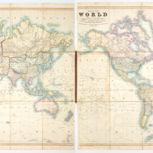
A lovely and clever representation of the world, with its most prominent mountains and rivers.
The World in Hemispheres.
Out of stock
Description
This is an attractive c. 1850 map of the world in hemispheres, with hand-colored outlines and depictions of the world’s tallest mountains and longest rivers. It appeared in William and Alexander Keith Johnston’s The national atlas of historical, commercial, and political geography.
The world is divided into western and eastern hemispheres, with continents outlined and a special pink outline for possessions of the British Empire. Antarctica is suggested by coastal discoveries but not represented as a distinct continent. Similarly, only cursory details are provided on the interior of Africa and Australia. On the other hand, islands in the Atlantic and Pacific are noted in considerable detail, reflecting the discoveries of the previous century.
Outside of the map itself, river systems are illustrated at top-left and right, along with the mountains which feed them. At bottom, the highest mountains on each continent are represented alongside each other and labeled with numbers corresponding to an index at bottom. Cities, such as Potosi, outposts, such as the Hospice St.-Bernard, and other features are noted with lowercase letters, also explained in the index. A balloon at left is labeled “Gay Lussac,” referring to the scientist Joseph Louis Gay-Lussac, who in 1804 ascended to just over 23,000 feet in a hydrogen balloon. A block of text below the meeting point of the hemispheres lists the area and population of the individual continents and the entire world.
Aside from its aesthetic qualities, this is a comprehensive sheet, almost an atlas unto itself.
Cartographer(s):
William and Alexander Keith Johnston were Scottish brothers based in Edinburgh who operated a prominent map engraving and printing business in the mid-19th century. A.K. Johnston was the driving force behind the business and remained in the world of cartography throughout his life, while William later entered politics, serving as the Lord Provost of Edinburgh and being knighted for his service. Johnston’s maps and atlases earned high praise for their accuracy and comprehensiveness (A.K. Johnston was strongly influenced by Alexander von Humboldt).
Condition Description
Very good. Toning along edges. Archival tape reinforcing bottom of centerfold on verso. Light foxing on verso.
References