With Robert Walton’s rare world map.
The history of the vvorld: or, An account of time. Compiled by the learned Dionisius Petavius. And continued by others, to the year of our Lord, 1659. Together with a geographicall description of Europe, Asia, Africa, and America.
$11,500
In stock
Description
This seminal work encapsulates some of the most critical intellectual and geographical developments in the late 16th and early 17th centuries. It was compiled by Dionysius Petavius, who perhaps is better known under his original French name, Denis Pétau. Pétau was an important Jesuit scholar and polymath who formulated an innovative approach to history and historical geography. Conceptualized in the wake of Sir Walter Raleigh’s seminal Historie of the VVorld In Five Bookes (1614), Pétau claimed that it was possible to come to a precise knowledge of Biblical chronology and use it to formulate a more exact history of the world.
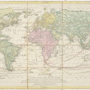
The current tome was published posthumously in London. It summarizes Pétau’s efforts to compile a new structure for historical study and combines two essential works in one volume: a history of time and a geographical description of the world. Unusually, Neatline’s example of this work includes a rare and important world map in two hemispheres by Robert Walton.
First published in 1656, Walton’s map was heavily based on John Speed’s A New and Accurat Map the World (1626) and is often mistaken as a later state of Speed’s map due to similarities in the map’s title and configuration. Walton’s map is rarer than that of Speed. Neatline’s copy of Petau’s work is the 1659 edition, which, as expected, contains the third state of Walton’s map (Shirley 397).
Robert Walton’s A New and Accurat Map of the World
There are many reasons why this map has become an icon in the world of map collecting and scholarship. In addition to its rarity, Walton’s map draws very directly on John Speed’s A New and Accurat Map the World: one of the first world maps compiled and published by an Englishman in English. Like its forebear, Walton’s map is a masterpiece in cartographic design, with an incredible amount of detail.
The map is a beautifully constructed double hemisphere, which combines the finest traditions of English and Dutch mapmaking to create a rare variant of one of the most celebrated aesthetic charts of the age. Surrounding the two hemispheres, we find the abundant ornamentation for which 17th-century maps were famous, but in this case, the composition and appearance of the map also reflect the transition from one stylistic or aesthetic paradigm to another. This is reflected in the wealth of decorative features like sea monsters and ships, which belong squarely within late 16th and early 17th century traditions.
Yet the traditional elaborations on the chart itself have, in this case, been overshadowed by the pictorial margins surrounding the two hemispheres. Among the elaborate decorative elements, we find mythological, cosmographical, and scientific scenes, as well as ample references to the age of exploration in which this chart was produced. Perched between the two terrestrial hemispheres, we find two smaller globes with celestial charts depicting the Northern and Southern Hemispheres, respectively. This juxtaposition of the heavens into northern and southern hemispheres, while the Earth has been divided into eastern and western hemispheres, is but one of the many elegant juxtapositions in Speed’s chart.
Among the abundant important cartographic details, we find one of the first renditions of the pioneer settlement of New Plymouth, as well as early depictions of both California and Korea as islands. The map also includes mythological features such as the non-existent island of Frisland off Greenland or the imagined Straits of Anian in the Pacific Northwest. At the bottom of both hemispheres, we see an enormous unexplored continent, which in the western hemisphere has been labeled MAGALLANICA in reference to Ferdinand Magellan’s famous circumnavigation of the earth (1519-1522).
Circumnavigation is generally a theme in this early world map. In addition to the toponymic references to Magellan, we find him among a series of four portraits of 17th-century explorers, all of whom managed the incredible challenge of sailing around the world. In addition to Magellan, we find Sir Francis Drake, who raided the Spanish settlement in America and escaped retribution by unexpectedly crossing the Pacific; the English privateer and explorer Thomas Cavendish, who deliberately tried to copy the feat pulled off by Drake; and then there is the merchant pirate Oilver van der Noort, who was the first Dutchman to sail around the earth.
Cartographer(s):
Denis Pétau, also known as Dionysius Petavius (1583-1652), was a French Jesuit theologian from Orléans. He received his initial education locally and later pursued studies at the University of Paris, where he distinguished himself by defending theses for the degree of Master of Arts in Greek rather than Latin. Following theological lectures at the Sorbonne, he secured the chair of philosophy at Bourges based on the recommendation of Nicolas Ysambert. Pétau’s scholarly pursuits led to a friendship with Isaac Casaubon, the royal library’s librarian, where he dedicated his spare time to studying ancient Greek manuscripts. Pétau was ordained as a deacon in Orléans in 1603 and received a canonry soon after.
In 1605, Pétau joined the Society of Jesus, subsequently teaching rhetoric at various institutions, including Reims (1609), La Flèche (1613), and the Collège de Clermont (1618). His academic contributions include correspondence with Fronton du Duc on John Chrysostom’s works. After a brief lecturing stint in Madrid in 1629, at the invitation of Philip IV, and a second trip to Rome in 1639, where he declined the offer of cardinalship from Pope Urban VIII, Pétau dedicated the remaining years of his life to his magnum opus, the Dogmata theologica. He concluded his teaching career at the age of sixty but continued as a librarian in Paris until his death. One of the Moon’s craters is named Petavius in his honor.
Robert WaltonRobert Walton was an English mapmaker and publisher active during the 17th century. Walton’s work was part of a broader movement in the 17th century that saw significant advancements in mapmaking and navigation. This period was marked by increased exploration and trade, which fueled the demand for accurate maps. Mapmakers like Walton played a crucial role in providing navigators and explorers with the tools they needed to traverse the world’s oceans and understand its geographies.
Condition Description
Map repaired and lined with Japanese tissue. Book re-backed spine over, with a new period-correct gilt label based on the impression left by the original label.
References