The first printed view of San Francisco’s Mission District.
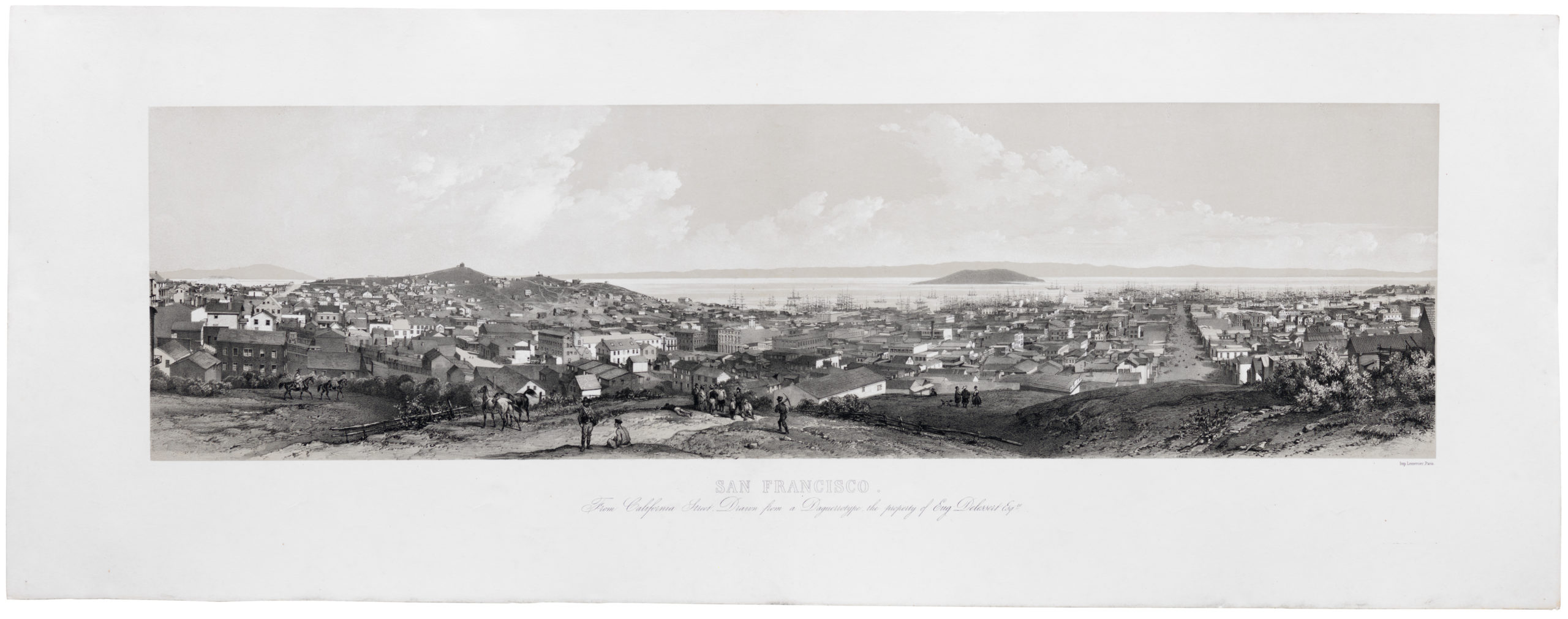
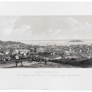
Mission Dolores, San Francisco – 1860, from the Potrero Nuevo
Out of stock
Description
This extraordinary view offers a detailed picture of the area around Mission Dolores, the first Spanish settlement in what would become the city of San Francisco. It is a rare piece of San Franciscana and a central addition to any collection focused on the city’s origins and early history.
Charles Gifford created a series of views of specific San Francisco neighborhoods, which Louis Nagel published in the 1860s. This Mission Dolores view is the most desirable. Gifford orients the scene towards the west, overlooking the mission and its surroundings from Potrero Hill and centering on the settlement’s main thoroughfare, which is today’s 16th Street. Looming in the background, we see Twin Peaks and Mt. Sutro, while Kite Hill and Tank Hill are visible on the right of the image.
The view reflects the appearance of the Mission in 1860, so more than a decade after the Gold Rush dramatically altered San Francisco. Nevertheless, the neighborhood has a bucolic feel, contrasting sharply with the bustling boom town port to its north. The reason for this contrast is that the Mission remained largely disconnected from the rest of San Francisco at this time, separated by enormous sand dunes that have since been blasted away. Despite the construction of a plank toll road, the best way to get from the San Francisco waterfront to the Mission was to sail a small boat around Mission Rock and up Mission Creek.
A note on the history of early Mission views
The majority of 19th-century depictions of the Mission District are either much later or essentially retrospective, providing quasi-historical portrayals based on memory, evolving origin narratives, and sheer romanticism. There are surprisingly few contemporary depictions of the Mission.
The oldest pictorial rendition of the Mission seems to be a French lithograph published in 1816, Danse des habitans de Californie a la mission de S. Francisco. This view shows Native Americans engaged in ritual dancing in front of the Mission buildings. A circa 1839 drawing by Captain William Smyth illustrates the fuller extent of the Mission compound and some surrounding buildings and hills.
The first depiction of the Mission and surrounding neighborhood comes from William H. Dougal, who in 1850 drew a view titled Mission Dolores, Looking Towards San Francisco. This view looks northeast across Mission Dolores from Liberty Hill (BANC PIC 1960.018:016b—A). It is not nearly as detailed as Gifford’s view, but core elements, like the mission quadrangle and the fenced line of what would later become Dolores Street, are discernible. In the distance, we see Mission Bay, San Francisco’s new harbor, and Yerba Buena Island.
We find nothing comparable until Gifford’s rendition from a decade later, making it the first printed map to focus on the Mission District. The Nahl Brothers also published a version of this same view in 1860.
Census
This view was drawn by Charles Gifford in 1860 and published by Louis Nagel. The only other known examples are held by the California State Library (no. 001440731CSL01-Aleph), the University of California Berkeley’s Bancroft Library as part of the Robert B. Honeyman Jr. Collection of Early Californian and Western American Pictorial Material (no. BANC PIC 1963.002:1544—D), the Stanford University as part of the Reid W. Dennis collection of California lithographs, and the Amon Carter Museum of American Art. None of these are listed separately by the OCLC.
The present example originates from the collection of the late, esteemed collector Charles A. Fracchia.
Context is everything
The area of the Mission District was originally inhabited by the Yelamu tribe of the Ohlone people who resided along the creek seen in the foreground (later dubbed Mission Creek). Spanish Franciscans founded the Mission San Francisco de Asís (more commonly known as the Mission Dolores) in 1776. The mission was relocated from its original site, a small chapel roughly 1,000 feet west, to the much larger structure that still stands today, seen in the background at the center.
By the early 18th century, the mission had grown to include farms, workshops, a school, a hospital, residences, and more, and the number of residents had risen to several thousand. However, its fortunes quickly declined as disease decimated the mission’s mostly indigenous population, and Mexican independence from Spain led to the secularization of the mission’s lands.
Most of the future Mission District was sold to rancheros, whose names (Valenciano, Bernal, Guerrero, Noe) are retained in local streets and neighborhoods. Gifford drew this view from Potrero Hill (then the Potrero Nuevo, meaning “new pasture”), owned at the time of the Mexican-American War by Francisco de Haro, a ranchero and alcalde of San Francisco who commissioned the first land survey of the city (then Yerba Buena).
In the wake of the California Gold Rush, plank roads were built through the surrounding marshlands in order to connect downtown San Francisco to the area around the Mission. Housing, industry, and other forms of development soon followed, and the intermingling of agriculture and industry is already evident in this historical view of the area. The area soon developed a reputation for unsavory forms of entertainment, including saloons, racetracks, bullfighting, and gambling.
A significant portion of the land in this Gifford view was purchased by John Center, a Scottish Forty-Eighter who owned the “Center Woolen Mills” and surrounding lands in the foreground at right. Atypically for the city, the Mission was not supplied by the Spring Valley Water Company. John Center dug wells around the district to provide residents with drinking water.
When catastrophe hit San Francisco in the early morning of April 18th, 1906, the Mission area suffered significant damage to its buildings and street due to massive liquefaction. However, the area did not see the same level of fire damage as downtown San Francisco thanks to a single functioning fire hydrant supplied by Center’s wells that allowed for fire suppression.
Cartographer(s):
Charles Braddock Gifford (1829 – November 17, 1888) was an American draughtsman, landscape artist, lithographer, and painter of city views based in and around San Francisco in the late 19th century. Gifford was born in New Bedford, Massachusetts, and worked there as a carpenter until about 1855, around which time he headed west to seek his fortune. By 1860, Gifford had established himself as a lithographer and landscape artist in San Francisco. His wife, Josephina, was from Nicaragua, and his earliest views include scenes of Mission Dolores, Vallejo, and Santa Clara. Gifford collaborated first with publisher Louis Nagel and subsequently with Bancroft. He began producing views in 1860 and continued to issue new views with various publishers until about 1877. He is best known for his highly ambitious 1862 view of the city on five large panels measuring some 9 feet across, published with A. Rosenfeld. He issued approximately fifteen views in total, most of which were of greater San Francisco. Gifford died in San Mateo in 1888.
Louis NagelLouis Nagel (July 28, 1818 – August 10, 1870) was a printer and lithographer active in the early decades of San Francisco. Born in Germany, Nagel emigrated to New York City in the early 1840s and set up shop as a printer with Adam Weingärtner. By 1858, he had relocated to San Francisco and continued to work as a printer, including collaborations with Charles Gifford, which are among the most important early views of the city.
Condition Description
Marginal tear, expertly repaired on verso.
References