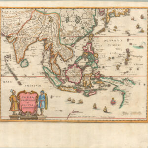
1490 Ptolemaic map of the Indian Subcontinent.
Decima Asiae Tabula.
Out of stock
Description
From the 1490 edition of the Rome Ptolemy, this map is an outstanding example of the Decima Asiae Tabula or ‘Tenth Asia Plate,’ which shows the entirety of the Indian Subcontinent, including the countries and regions we know today as India, Pakistan, Bangladesh, and Tibet.
The map features all the hallmarks of the Ptolemaic conception of this region. India has been compressed into the Asian landmass, dramatically reducing the size of its southernmost tip. While this configuration is far from reality and soon would be remedied by actual observation-based cartography, flattening the Indian Subcontinent in this manner was not at all unusual at this early stage of mapping the world.
Despite the strange appearance of the Subcontinent, this map has many recognizable elements and is framed by its two great rivers. Along the left edge of the map, we see the Indus River (Indus Fluvius) emptying into the Arabian Sea just above the Gulf of Kutch (Sinus Canthicolpus). Along the opposite fringe, in West Bengal, we find the Ganges, which, like the Indus, flows via an elaborately drawn delta into the sea. The large landmass between them is labeled INDIA INTRA GANGEM FLUVIUM (“India inside the Ganges River”). Today, the subcontinent is still defined geographically by these two great rivers, underscoring how natural barriers such as mountains, oceans, or rivers have always been used to delineate regions.
While the strange flatness of the Indian landmass may seem exotic to us today, we must remember that this visualization was compiled based directly on the information conveyed in a 2nd-century gazetteer of the known world. The Romans had been trading with India for centuries when Ptolemy wrote his book, setting up Roman ports on the Red Sea and using the monsoon winds to cross the Indian Ocean in the same manner as many indigenous communities. Roman scholars thus had direct knowledge of this region, which was embedded directly into this map.
Anyone familiar with Roman sources will have heard of great trading centers like Muziris or Colchi. On this map, the latter has even been given the Latin title of emporium, which implies a center of international trade. This terminology is applied to a number of coastal towns on the map, but notably only on what is the Subcontinent’s western coastline. While the eastern coast is just as well represented visually, the toponymy is more sporadic and vague.
When our map was produced in the 15th century, Italian city-states primarily controlled trade with India, which depended on the goodwill and collaboration of the Mamluk Dynasty of Egypt. It was a fragile system at best, but that would all change after Bartolomeu Dias rounded the Cape of Good Hope in 1488 and thus opened a sea route to India for the Portuguese. Once the Portuguese breached the Indian Ocean, their superior firepower and military technology soon meant they were Western India’s new and dominant trading partner. It was not strange that the discovery also prompted a new edition of the Rome Cosmographia, published in 1490 and from which our map derives. The revised edition included several textual references to Dias’ feat and the associated discoveries, but these updates were never integrated into the maps, implying that they retain the Classical outlook of Ptolemy’s original text.
The current map is a bridge between ages: While the interests that drove this map’s creation were very much tied to the political and economic developments of the 15th century, the nature of its appearance is wholly anchored in Antiquity. It is a manifestation of how keen Europeans were to classify and understand the world but simultaneously a revelation of how archaic and obtuse that understanding still was at this stage.
Provenance
Maps dating to the 15th century are increasingly scarce on the market and generally command significant prices. Neatline has acquired our example of this map from the estate of an established private collector in Sweden.
Ptolemaic maps of the 15th century
While translations of Ptolemy’s Geographia into Greek and Latin had been around for more than a century when this map was published, only in 1477 did the first printed version with maps appear in Bologna. The following year, a similar edition was printed in Rome, although many of the maps looked distinctly different. Most scholars agree that the maps of the 1478 Rome edition were probably compiled before those of the Bologna. However, the compilation and printing of the Bologna edition was a faster process. Regardless of which came first, the same small circle of men apparently engraved both sets of maps.
Among the known mapmakers were two Germans, Conrad Sweynheym and Arnold Pannartz, who had trained with Gutenberg himself and who were responsible for bringing printing press technology to Italy. Sweynheym also developed a printing method for finely engraved copper plates, and he seems to have been behind most of the Bologna and Rome editions’ maps. However, Sweynheym died a year before the Bologna edition was published. So the printer of the first Rome edition, Arnold Buckinck, is presumed to have finished the plates started by Sweynheym himself.
In 1490, these plates were purchased by the Spanish printer Petrus de Turre (Pedro de la Torre), who quickly used them to publish a second edition of the Rome Ptolemy using the same plates. It is from this edition that our sheet comes.
Between the publication of the original Rome edition and the second edition by de Turre, two other important Ptolemaic atlases were produced, both in 1482. The Italian Francesco Niccolo Berlinghieri compiled a work that was not a Ptolemaic atlas in the traditional sense but rather a description of the world in Italian verse supported with Ptolemaic style maps. The other was the so-called Ulm Edition of Ptolemy, the first printed atlas to be produced outside Italy.
Cartographer(s):
Roman geographer and mathematician Claudius Ptolemy (c. 100 – 170 CE) solidified geography as an independent discipline.
The Ptolemaic understanding of the world stems from Ptolemy’s seminal work, Geographia. Initially intended to revise and critique another (now lost) geography written by Marinus of Tyre, Ptolemy compiled Geographia in Alexandria around 150 CE. It consisted of a treatise on world geography, instructions on making maps, and a topographically-anchored gazetteer. It forms the basis of scientific cartography: a coordinate-based system meant that future cartographers (even many centuries later) could recreate its maps using the published data. The work covered an area from the Canary Islands in the west to the coasts of China and Korea in the east.
Pietro de la TorrePietro de la Torre was a Spanish mapmaker, engraver, and printer living in Italy. He is most famous for acquiring the plates of the 1478 Rome edition of Ptolemy and issuing his own edition of the atlas in 1490.
Condition Description
Excellent.
References
Destombes, Marcel (1952). Catalogue des cartes gravées au xve siècle.
Nordenskiöld, Adolf E. (1973) Facsimile Atlas to the early History of Cartography with Reproductions of the Most Important Maps Printed in the XV and XVI Centuries, New York.
Peerlings, Robert H.J., Frans Laurentius & Jaap van den Bovenkamp (2017). The Watermarks in the Rome editions of Ptolemy and More, Quaerendo 47: 307-27.
Peerlings, Robert H.J., Frans Laurentius & Jaap van den Bovenkamp (2018). New Findings and Discoveries in the 1507/8 Rome Edition of Ptolemy’s Cosmography, Quaerendo 48: 139-62.
Skelton, R.A. (1966). Claudius Ptolemaeus, Cosmographia: Roma 1478, with an introduction by Raleigh A. Skelton, Amsterdam.
Stevens, Henry N. (1972) Ptolemy’s Geography: A brief account of all the printed editions down to 1730, Amsterdam. Zedler, Gottfried (1901). Gutenberg-Forschungen von Gottfried Zedler. Leipzig.
![[Sri Lanka] Tabula Duodecima Dasia](https://neatlinemaps.com/wp-content/uploads/2023/03/NL-01721_thumbnail-300x300.jpg)