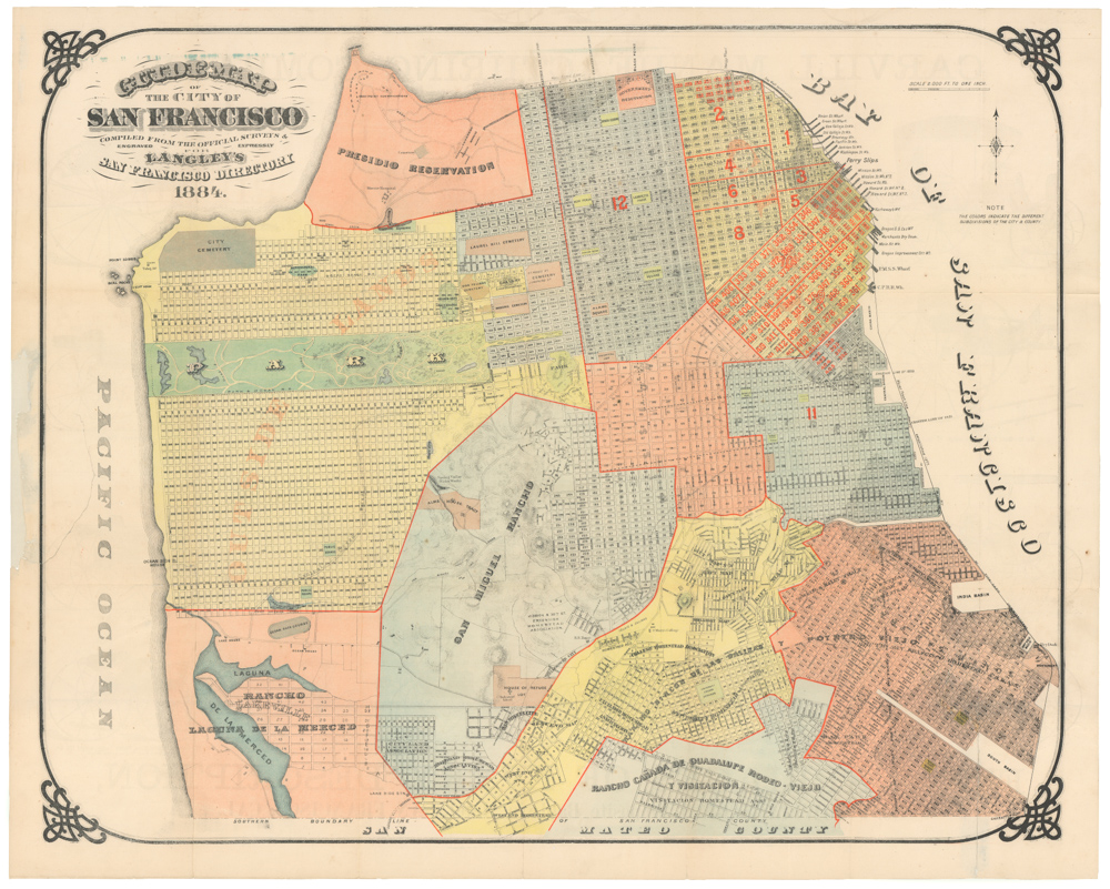
The definitive Silver Rush plan of a new and expanded San Francisco.
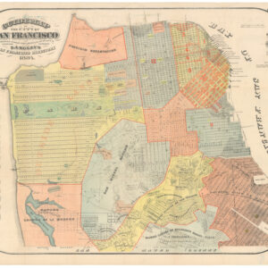
Official Map Of The City Of San Francisco, California. Published by Josiah J. LeCount…Approved By Geo. R. Turner City & County Surveyor
$12,500
1 in stock
Description
With annotations referring to some of the most important legal battles of the era and references to Dennis Mahoney, a pioneer settler and one of San Francisco’s first entrepreneurs.
A scarce and important early map of San Francisco, based on official surveys and development plans, issued at the beginning of the Comstock Silver Rush. This particular example refers directly to legal actions taken by one of the city’s most influential entrepreneurs and landowners, making it a unique historical document. It was compiled by local book dealer Josiah LeCount and engraved and printed by the iconic San Francisco duo Britton & Rey.
The map was published in 1859, shortly after the discovery of the Comstock Lode. It is the definitive plan produced as San Francisco was beginning a new period of growth and expansion. Notably, the map depicts both the block and street system of San Francisco as it already existed and also as it was projected to develop in the coming years. In devising the map, Le Count was given special access to the archive of city maps, property surveys, and projected development plans held by George R. Turner, Surveyor of the City & County of San Francisco. While the map was a commercial publication, given its large format and exacting detail, it would have been considered invaluable by Turner’s office, the Board of Supervisors, and property owners.
The map is a cartographic vision of a distinctly modern American city. It covers an area stretching from the Bay in the east to Divisadero Street in the west and from Alta Street in the south (only five blocks from Mission Dolores) to Lewis Street in the north. As such, it covers the entire urban core of this boom town. Ten years earlier, it could hardly be called a city. Now, it was the most important American hub on the West Coast.
Turner realized that with the recent discovery of silver in Nevada, San Francisco was entering a new cycle of growth and expansion, which would require a rigid demarcation of who owned what and where. Indeed, in the period following this map’s creation, intense legal battles were fought over land ownership. Court cases were often dramatic and required the most up-to-date and detailed maps. LeCount’s map quickly became the go-to source in these disputes.
Provenance and use
The example offered here makes it evident that this document was used precisely to establish such legal claims. We find two small printed slips of paper glued to the margin and seemingly related to the hand-written notations on the map itself. Both texts define the extent of particular land holdings. The shorter text, pasted in the lower-left margin, appears to be cut from a newspaper or legal document defining the extent of a plot in the Western Addition. It discusses land purchased well before the new street grid was projected and states that the holdings in question essentially run through the middle of the block separating Fulton and Grove Streets, culminating in Alamo Square.
A more prominent slip, glued to the bottom of the map, also refers to a large land-holding in the Western Addition. Here too, the purpose of the text is to formally delineate a large plot. It refers directly to the legal dispute to which this delineation pertains: “The said action is brought to recover from said defendants, the possession of all that tract or parcel of land situate in the City and Council of San Francisco and State of California and described and bound as follows, to wit:” The text then goes on to define a swathe of land that stretches from Larkin Street to Laguna Street, and which includes all of what would soon become Lafayette Square.
Both slips have a name written in ink above them. While the smaller seemingly spells Moore or Moone, whom we cannot identify, the larger slip is headlined with the name ‘Dennis Mahoney.’ This is a name of some import in San Francisco history, as Mahoney was among the earliest European immigrants to settle in San Francisco. Both Dennis Mahoney Sr. and his son (same name) were influential entrepreneurs and landowners during the formative years of San Francisco.
Dennis Mahoney Sr. was born in Ireland in 1818 and emigrated to New York in 1838, where he married and had his first three children. Some years later, in August of 1849, he relocated to California, settling in the boom-town of San Francisco and becoming one of the city’s pioneers. After his family joined him from New York, the Mahoneys would have another eight children, many of whom became notable figures in San Francisco history. Mahoney first tried his luck in mining but soon realized this was not his metier. He then set up a ranch (Mahoney Rancho) outside town, where he focussed on raising sheep. As the Gold Rush brought in money, people, and supplies, Mahoney realized that with the population growth came the growing need for food. He set up the city’s first slaughterhouse on the corner of Jackson Street and Van Ness Avenue. This enterprise made him a rich man, and Mahoney used this money to invest heavily in real estate, eventually owning some of the most valuable lands in the city.
The map comes from the private collection of Charles A. Fracchia, historian of California and San Francisco, a Fellow of the California Historical Society, the Founder and President Emeritus of the San Francisco Museum and Historical Society, and one of the founders of Rolling Stone magazine. Fracchia was an avid collector who had a keen eye for California history.
Other notations on the map
The map is covered with period ink annotations that define the ownership of large swathes of land in the Western Addition. A significant section at the northeast corner of Lafayette Square in what today is known as Pacific Heights is marked with the name ‘Stevenson.’ This is most likely a reference to a Col. Jonathan Drake Stevenson, who brought his First Regiment of New York Volunteers to California as early as 1846. Later Stevenson also organized the establishment of a regiment of volunteers from San Francisco. After the Mexican-American war, Stevenson settled in the mining community of Mokelumne Hill, where he was made alcalde. He returned to San Francisco to enter the real estate business with Dr. William C. Parker, who had been assistant surgeon in the Regiment of New York Volunteers.
In 1849, Stevenson bought the southern half of Rancho Los Medanos. Here he planned the new town of “New York of the Pacific”(changed to Pittsburg in 1911). He was active in Freemasonry and was both founder and grand master of the San Francisco lodge. In 1872, he was made Shipping Commissioner for the Port of San Francisco. There is a Stevenson Street in his honor as early as 1849.
Nearby we see a four block section overwritten with the names Herrick & Rowley. Herrick could refer to Samuel Herrick, a well-known patent attorney from Washington, D.C. who hired famous SF trial lawyer T.L. Christianson as his California representative. However, it is perhaps more likely to refer to Ebenezer Herrick Dyer, brother Ephraim Dyer and San Francisco’s biggest sugar magnate.
Below that, in large letters, is the name Dyer. This probably refers to Ephraim Dyer Sr. of Sullivan, Maine, who in 1850 sailed to California, struck by gold fever. Arriving in San Francisco, he worked various jobs and then went to Union City to work for the farmer and rancher, J.M. Horner. In 1858, Dyer was the first passenger to make the journey to Maine via the Overland Mail Railroad, exploring whether driving cattle cross country was viable. He returned to California by steamship with his new wife in 1859. They settled in Alvarado, where he was appointed U.S. Deputy Surveyor in 1861. He conducted several Government surveys for the land that extended from the Oregon border to Lake Tahoe (hence Mount Dyer).
In 1864, Ephraim Dyer, Sr. was elected Captain and Commander of the California State Militia. In 1870, he invested in his family’s sugar-manufacturing business built by his brother, Ebenezer Herrick Dyer, and became a rich man. Calisphere contains at least three hand-drawn survey maps of ‘ranches’ executed by Ephraim Dyer in the early 1860s. This was probably done in his role as surveyor, and not as land owner.
Context is everything
San Francisco became America’s great western hub after the Gold Rush attracted enormous numbers of immigrants to California in 1849-50. Over the next decade, San Francisco maintained much of this magnetism, drawing new hopefuls to California every day. With the discovery of the Comstock Lode in Nevada, a second wave of immigration washed over California and San Francisco. It brought enormous wealth to the region, in part because most of the Nevada silver flowed out through San Francisco. While the city had grown from a few thousand in 1849 to around 55,000 in 1859, when this map was issued, by 1869, the number of inhabitants had tripled to 150,000.
Lecount’s map constitutes the physical blueprint for this transformative period of growth. It was the first comprehensive and detailed plan of San Francisco that included the new projected neighborhoods and tapped directly into the massive interest generated by the discovery of silver. The map was so precise that not only was it sold to newcomers and potential immigrants, but it also became the primary cartographic reference in the label battles associated with San Francisco’s dramatic expansion in the 1860s. Any surviving copy of this map constitutes a historical document. However, this example is a very desirable collector’s copy due to its connection to Dennis Mahoney and the legal battles associated with San Francisco’s expansion.
Cartographer(s):
Britton & Rey (1852 – 1906) was a lithographic printing firm based in San Francisco and founded by Joseph Britton and Jacques Joseph Rey in 1852. Especially during the second half of the 19th century, Britton and Rey became the leading lithography firm in San Francisco, and probably California. Among their many publications were birds-eye-views of Californian cities, depictions of the exquisite landscapes, stock certificates, and no least maps. While Rey was the primary artist, Britton worked not only as the main lithographer but was essentially also the man running the business. In addition to their own material, the firm reproduced the works of other American artists like Thomas Almond Ayres (1816 – 1858), George Holbrook Baker (1824 – 1906), Charles Christian Nahl (1818 – 1878), and Frederick August Wenderoth (1819 – 1884). Following Rey’s death in 1892 Britton passed the form on to Rey’s son, Valentine J. A. Rey, who ran it until the great earthquake and fire of 1906 destroyed most of the company’s assets.
Joseph Britton (1825 – July 18, 1901) was a lithographer and the co-founder of the prominent San Francisco lithography studio Britton and Rey. He was also a civic leader in San Francisco, serving on the Board of Supervisors and helping to draft a new city charter. In 1852, he became active in lithography and publishing, first under the name ‘Pollard and Britton,’ and then ‘Britton and Rey,’ a printing company founded with his friend and eventual brother-in-law Jacques Joseph Rey. Britton and Rey became the premier lithographic and engraving studio of the Gold Rush era, producing letter sheets, maps, and artistic prints.
Jacques Joseph Rey (1820 – 1892) was a French engraver and lithographer born in the Alsatian town of Bouxwiller. At the age of about 30, he emigrated to America, eventually settling in California. Here, he soon entered into a partnership with local entrepreneur and civic leader Joseph Britton. Three years later, Rey also married Britton’s sister, allowing his business partner and brother-in-law Britton to live in their house with them. Rey and Britton were not only an important part of the San Francisco printing and publishing scene but also owned a plumbing and gas-fitting firm. In the early years, both men would sometimes partner up with others on specific projects, but by the late 1860s, their partnership was more or less exclusive.
Josiah J. LeCountJosiah J. LeCount was one of the most important figures in the emergent printing industry of San Francisco during the 1850s.
Shortly after arriving in 1849, LeCount founded a lithography business with William B. Cooke. This was dissolved a few years later (1852), and LeCount then set up his own company ‘Josiah J. LeCount, Manufacturer & Importer: Stationary, Law, School, Medical, & Miscellaneous Books.’ The business was located on Montgomery Street, in the heart of the city’s printers’ district.
While engaged primarily in the sale of books and stationery, LeCount also produced several important early maps of San Francisco, including an 1852 city plan with Alfred Wheeler and a smaller map for the San Francisco City Directory in 1854.
From around 1858, LeCount established a close working relationship with Britton & Rey, producing, among other things, a seminal map of San Francisco in 1859, which shows the city just before its explosive growth in the early 1860s.
Condition Description
Glued down on old backing board, some glue and tape stains, paper darkened, a few chips and small pieces missing.
References
![PORT OF SAN FRANCISCO. WHERE THE FAR EAST BEGINS [Japanese language version]](https://neatlinemaps.com/wp-content/uploads/2021/01/NL-00879_Thumbnail-300x300.jpg)
![PORT OF SAN FRANCISCO. WHERE THE FAR EAST BEGINS [Japanese language version]](https://neatlinemaps.com/wp-content/uploads/2021/01/NL-00879_Thumbnail.jpg)