Outstanding original color Visscher map of the Kingdom of Hungary, published at a time when the region hung in the balance.
Totius Regni Hungariae, Maximae que Partis Danubii Fluminis.
Out of stock
Description
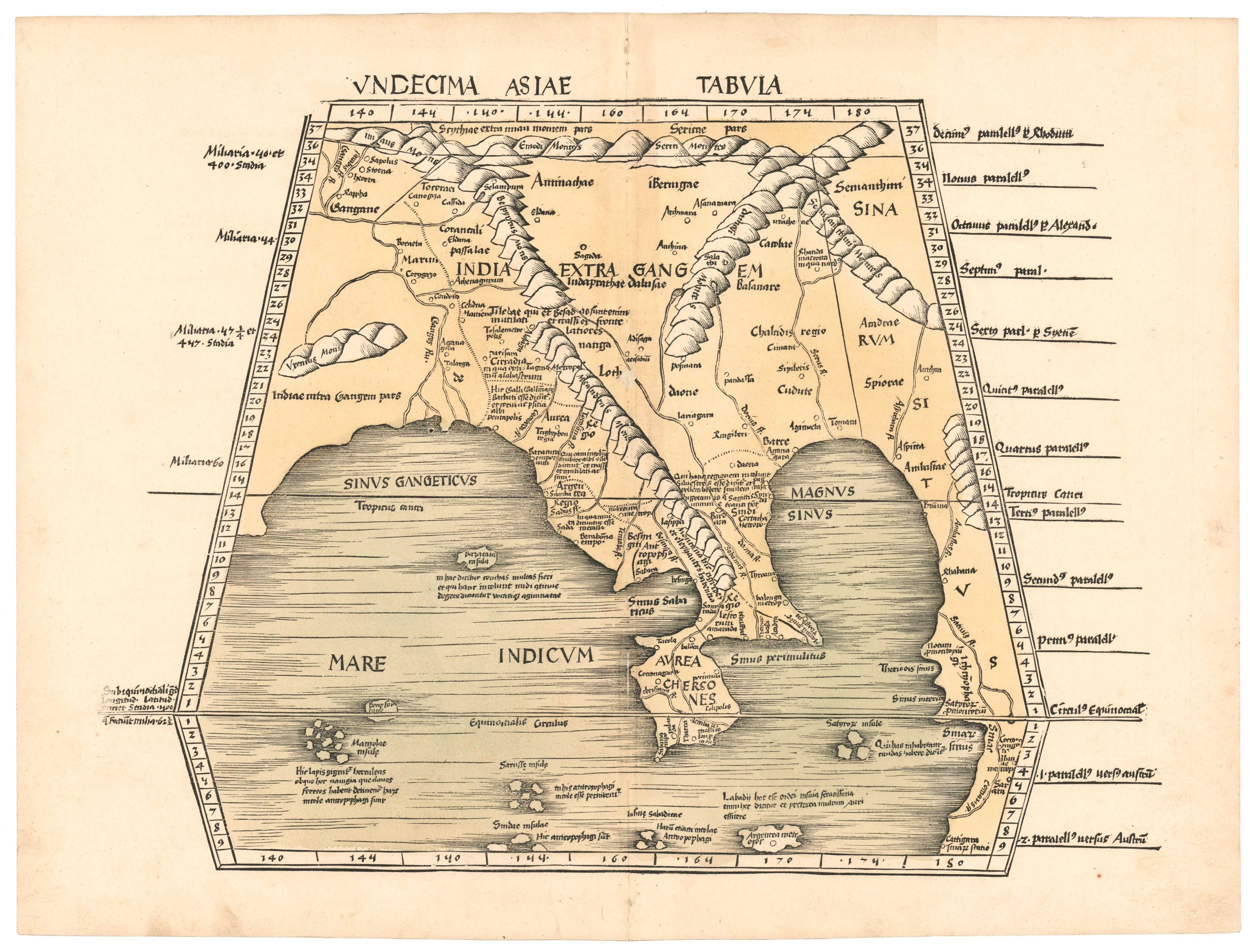
Published in a decade filled with momentous events in the region, this is a fantastic copperplate-engraved map of the Kingdom of Hungary, the powerful Central European monarchy that existed from about the year 1000 CE until the end of World War II. It extends from Venice, Prague, and Vienna on the western edge to Constantinople and the Black Sea on the eastern edge. Snaking its way in between, we find the mighty Danube River, along with its associated cities, towns, and tributaries.
The map was published during an era of great conflict between allied Christian European kingdoms and the Ottoman Empire. The Ottoman failure at the Siege of Vienna (1683) emboldened her enemies to launch an offensive, which led to the recapture of present-day Budapest in the Siege of Buda (1686). This chart captures the theater of these pivotal events in tremendous detail, brought to life by its attractive contemporary period outline color.
Cartographer(s):
Nicolaes Visscher I (1618 – 1679) was a prominent Dutch engraver, cartographer, and publisher who was born and worked in the Dutch capital of Amsterdam. He was the son of Claes Janszoon Visscher (1587 – 1652), who established the family’s publishing firm and cemented the family as some of the most prominent Dutch mapmakers for nearly a century. The firm initially lay near the offices of two other great Dutch mapmakers in Amsterdam, namely Pieter van den Keer and Jacodus Hondius, and most historians believe that Visscher senior probably had been apprenticed with Hondius.
Upon his father’s death, the firm was passed on to Nicholas Visscher, who in 1677 received Dutch royal privilege to issue maps. Nicholas Visscher’s son, Nicolaes Visscher II (1649–1702), trained with his father and took over the family business upon his death in 1679. When Visscher II died in 1702, his widow continued the firm until the plates were sold to Peter Schenk in the 1720s. The Visscher family stands as one of the most important in the history of Dutch cartography. In addition to the respective members’ names, many of their maps also bear the imprint Piscator, the Latinised version of the family name (Visscher means fisherman in Dutch). Sometimes, the maps even feature the image of an elderly fisherman.
Condition Description
Excellent original color and bright map image. Visible repairs and blemishes.
References


![[Title in Russian] Russian Empire in the 18th Century (European Section)](https://neatlinemaps.com/wp-content/uploads/2020/04/NL-00822_Thumbnail-300x300.jpg)
![[Title in Russian] Russian Empire in the 18th Century (European Section)](https://neatlinemaps.com/wp-content/uploads/2020/04/NL-00822-scaled.jpg)
![[Title in Russian] Russian Empire in the 18th Century (European Section)](https://neatlinemaps.com/wp-content/uploads/2020/04/NL-00822-scaled-300x300.jpg)