Out of stock
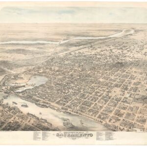
Augustus Koch’s rare and monumental 1870 view of Sacramento.
Cartographer(s):
Augustus Koch
Date: 1870
Place: San Francisco
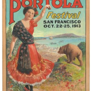
Original artwork for the 1913 Portola Festival – a unique piece of San Franciscana.
$8,500
Cartographer(s):
Anonymous
Date: 1913
Place: San Francisco
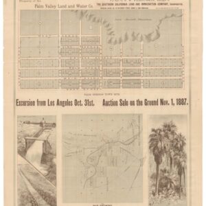
The Earliest Map of Palm Springs!
$7,500
Cartographer(s):
Britton & Rey, Southern Pacific Railroad
Date: 1887
Place: San Francisco
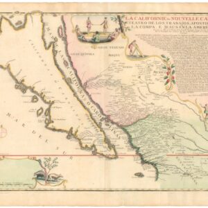
[Old Color] The largest cartographic depiction of the island of California ever made.
$7,500
Cartographer(s):
Nicholas de Fer
Date: 1720
Place: Paris
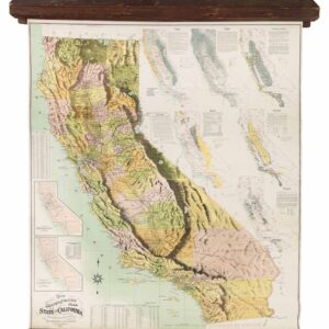
Whitaker & Ray’s monumental physiographic wall map of California with eight thematic insets.
$7,500
Cartographer(s):
Whitaker & Ray Co.
Date: 1902
Place: San Francisco
Out of stock
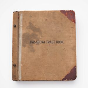
An extremely rare tract book of Pasadena and Altadena, with numerous unrecorded pasted-in extra maps.
Cartographer(s):
Albert G. Thurston
Date: 1927
Place: Pasadena, CA
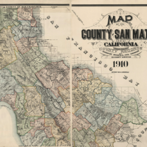
Before Silicon Valley: a stunning, large-scale 1910 map of San Mateo County.
$6,500
Cartographer(s):
Davenport Bromfield, Britton & Rey
Date: 1910
Place: San Francisco
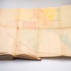
Late 19th-century assessment with two fold-out maps, including a very early map of Walnut Creek.
$4,500
Cartographer(s):
California State Board of Equalization
Date: 1895
Place: Not listed
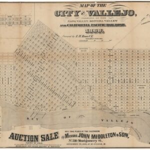
The first official town plan of Vallejo.
$4,500
Cartographer(s):
E.H. Rowe, Britton & Rey
Date: 1868
Place: San Francisco
Out of stock
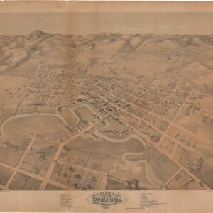
One of the earliest views of Petaluma.
Cartographer(s):
Augustus Koch, Britton & Rey
Date: 1871
Place: San Francisco
Out of stock
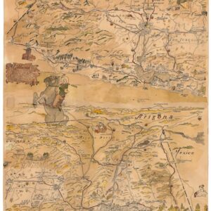
A unique, hand-drawn, and watercolored mid-century pictorial map of California.
Cartographer(s):
R.C. Hicks
Date: 1940
Place: Not listed
Out of stock
![Map of the City of San Jose [manuscript].](https://neatlinemaps.com/wp-content/uploads/2025/02/NL-02336_thumbnail-300x300.jpg)
A monumental manuscript map of San Jose, the most comprehensive map of the city we have ever seen.
Cartographer(s):
Chief Engineer's Office
Date: 1917
Place: San Francisco
![[Bay Area Road Atlas] Auto Roads of San Francisco and Oakland to Monterey and Santa Cruz.](https://neatlinemaps.com/wp-content/uploads/2024/05/NL-01940_thumbnail-300x300.jpg)
A pioneering road atlas covering the Bay Area and Monterey.
$2,800
Cartographer(s):
C.J. Gray & Co.
Date: 1908
Place: Los Angeles

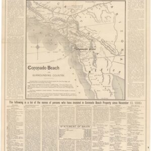
The seldom seen large-format edition of Rand McNally’s map of Coronado Beach, San Diego.
$2,800
Cartographer(s):
Rand, McNally & Co.
Date: 1887
Place: Chicago
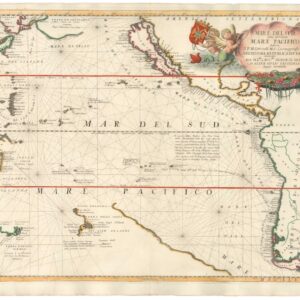
An excellent example of Coronelli’s Pacific Ocean with California as an Island.
$2,500
Cartographer(s):
Vincenzo Coronelli
Date: 1691
Place: Venice
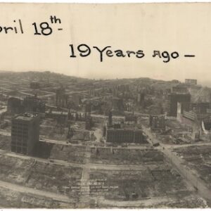
Large, dramatic panoramic photograph surveying the devastation of the 1906 San Francisco earthquake and fire.
$2,400
Cartographer(s):
George Lawrence
Date: 1906
Place: Chicago
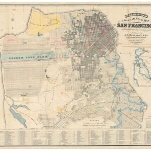
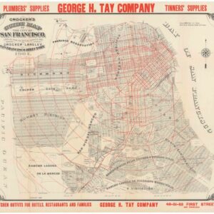
One of the most iconic 19th-century maps of San Francisco.
$2,200
Cartographer(s):
The Bancroft Company
Date: 1877
Place: San Francisco
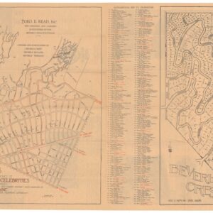
Beverly Hills’ First Star Homes Map?
$1,900
Cartographer(s):
George E. Read, Inc.
Date: 1926
Place: Beverly Hills, Calif.

A superb pictorial map of Hollywood, California.
$1,800
Cartographer(s):
Ranlee Publishing Inc.
Date: 1985
Place: Englewood Cliffs, NJ
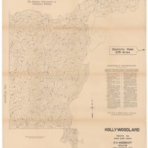
The birth of one of L.A.’s most iconic neighborhoods.
$1,800
Cartographer(s):
Sidney H. Woodruff, Engineering Service Corp.
Date: 1923
Place: Los Angeles
A fantastic pre-1906 earthquake map of San Francisco.
$1,600
Cartographer(s):
H. S. Crocker Company, Henry G. Langley
Date: 1901
Place: San Francisco
![[Central Valley Agricultural Photo Album].](https://neatlinemaps.com/wp-content/uploads/2025/02/NL-02294-1_thumbnail-300x300.jpg)
A unique collection of early 20th-century photographs of the Central Valley.
$1,400
Cartographer(s):
Anonymous
Date: 1915
Place: Not listed
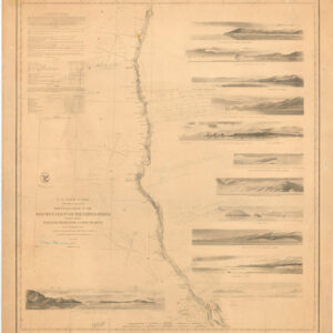
Eminent geographer and historian George Davidson tracks the West Coast voyage of Sebastian Vizcaino.
$1,400
Cartographer(s):
Office of the Coast Survey
Date: 1854
Place: Washington, D.C.
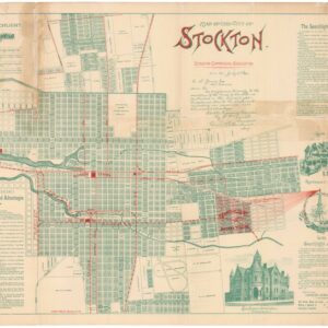
A rare Dakin map of Stockton at the end of the 19th century.
$1,250
Cartographer(s):
Dakin Publishing Company
Date: 1895
Place: San Francisco
Out of stock
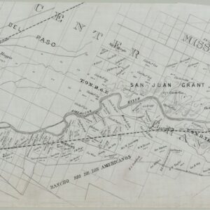
Fascinating manuscript map of the American River capturing the Sacramento Valley from Sacramento to Folsom.
Cartographer(s):
Thomas Barbour
Date: 1902
Place: San Francisco
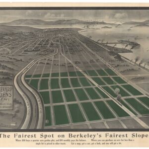
North Berkeley’s Golden Past: a rare 1907 view of Boulevard Gardens.
$1,200
Cartographer(s):
Schmidt-Skilling Co., Charles Green
Date: 1907
Place: Oakland
Early 1887 Promotional Broadside for the Hotel Del Coronado.
$1,200
Cartographer(s):
Rand, McNally & Co.
Date: 1887
Place: Chicago
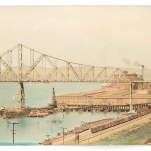
A rare panorama of old Carquinez bridge and the Crockett sugar factory.
$1,200
Cartographer(s):
Morton & Co.
Date: 1930
Place: San Francisco
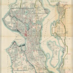
The famous ‘Bogue Plan’ of Seattle: an ambitious urban design for the city and environs from 1911.
$1,200
Cartographer(s):
Virgil G. Bogue, Engineer, Tucker Hanford Co.
Date: 1911
Place: Seattle
Out of stock
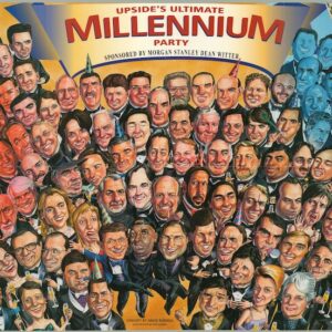
[Silicon Valley History] A time capsule of the dot-com era.
Cartographer(s):
David Bunnell, Ron Barber, Upside Media, Inc.
Date: 2000
Place: Not listed
Out of stock
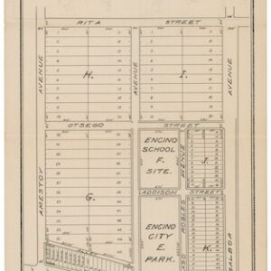
A rare early promotional tract map of Encino City, San Fernando Valley.
Cartographer(s):
William Hamilton Hay
Date: 1922
Place: Los Angeles
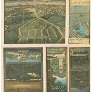
[Housing Discrimination] Promotional map for East Piedmont Heights with implicit racial restrictions.
$975
Cartographer(s):
Wickham Havens Inc., William H. Bull
Date: 1907
Place: Oakland
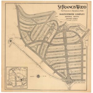
A rare circa 1912 cadastral plan of the nascent San Francisco neighborhood of St. Francis Wood.
$875
Cartographer(s):
Mason-McDuffie Co.
Date: 1912
Place: San Francisco

A unique manuscript blueprint for the Atchinson, Topeka and Santa Fe Railway Company’s San Pablo Ferry.
$775
Cartographer(s):
Frank B. King
Date: 1901
Place: Los Angeles
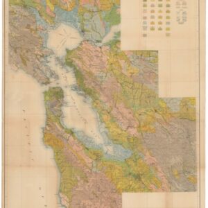
A massive 1914 San Francisco Bay Area Department of Agriculture Soil Map.
$750
Cartographer(s):
U.S. Department of Agriculture, Bureau of Soils
Date: 1914
Place: New York
Out of stock
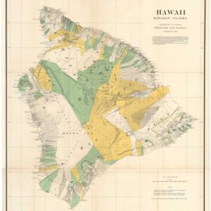
Documenting the Privatization of Land in Hawaiʻi.
Cartographer(s):
Julius Bien & Co.
Date: 1901
Place: New York
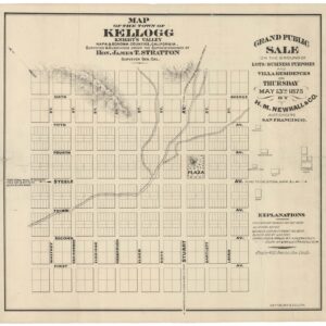
A scarce 1875 Britton & Rey lot sale map of Kellogg, California.
$725
Cartographer(s):
Britton & Rey
Date: 1875
Place: San Francisco
With a hand-written annotation by J.N. Lentell, one of the most important surveyors of 19th-century California.
$675
Cartographer(s):
J.N. Lentell, James Talbot Ryan
Date: 1886
Place: Eureka, CA
![[Redwood City] Oakleigh Park.](https://neatlinemaps.com/wp-content/uploads/2025/02/NL-02339_thumbnail-300x300.jpg)
A seemingly unrecorded brochure for Oakleigh Park in Redwood City, complete with a bird’s-eye-view.
$650
Cartographer(s):
Oakleigh Park Co.
Date: 1910
Place: San Francisco
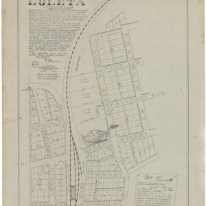
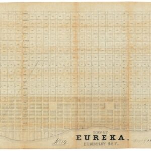
A unique manuscript map of Loleta by famous Humboldt County surveyor Frank Herrick.
$650
Cartographer(s):
Frank Ephraim Herrick
Date: 1899
Place: Eureka
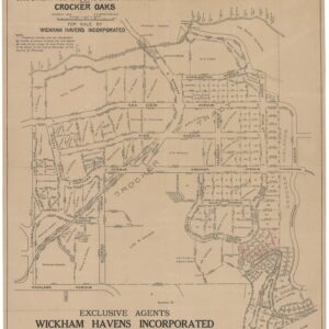
Edward Prather’s 1914 cadastral map of the Crocker Highlands development in Oakland.
$650
Cartographer(s):
Wickham Havens Inc., Edward C. Prather
Date: 1914
Place: Oakland
![[Visitacion Valley SF] Abstract of Title and List of Incumbrances on Reis Tract part Visitacion Rancho.](https://neatlinemaps.com/wp-content/uploads/2025/01/NL-02325-cover_thumbnail-300x300.jpg)
Rare Abstract of Title for San Francisco’s Reis Tract, with an early and uncertified cadastral map.
$650
Cartographer(s):
Ferdinand Reis
Date: 1904
Place: San Francisco
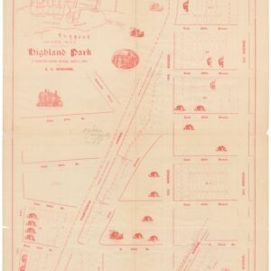
An 1893 Highland Park auction map with house vignettes.
$475
Cartographer(s):
Edward Carthcart "E.C." Sessions
Date: 1893
Place: Oakland

An early promotional map of Emeryville.
$400
Cartographer(s):
Baldwin & Howell
Date: 1920
Place: San Francisco