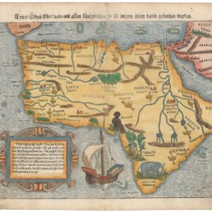
1541 Ptolemaic map of West Africa with mythical kings and beasts.
Tabula Nova Partis Africae
Out of stock
Description
Based on a map by Waldseemüller map, this is one of the earliest “modern” maps of northwest Africa. The map extends from the Mediterranean to the Equator, and from the Canary Islands to the Red Sea. Details are focused primarily along the coastline, with numerous place names noted. The interior of Africa is filled with spurious mountain ranges and rivers.
The map is adorned with depictions of kings on their thrones, a Cyclops, a rhino, and a pair of water buffalo.
Cartographer(s):
Laurent/Lorenz Fries (ca. 1485-1532) was born in Alsace circa 1490 and studied medicine and mathematics at a number of European universities. He was trained as a physician but was also keenly interested in cartography and medical publications. From 1518-19 Fries is mainly based in Strasbourg, where he was commissioned to compile the first edition of Waldseemüller’s atlas after his death in 1520.
Condition Description
A crisp impression on a clean and bright sheet with a bunch of grapes watermark and minor foxing in the top blank margin. There are professional repairs to a few tiny worm holes along the centerfold.
References
Mickwitz Miekkavaara #211-38; cf. Norwich #286.
