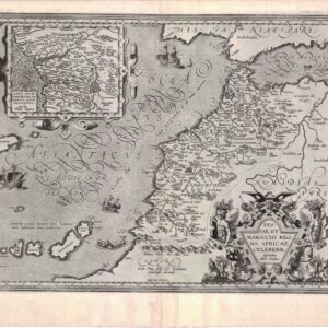
Vivid 1943 pictorial map of Morocco.
Maroc. Région Nord
$275
1 in stock
Description
This is a vibrant pictorial map titled “Maroc – Région Nord” (Morocco, Northern Region), a mid-20th-century French colonial–era illustration that celebrates Morocco’s northern provinces in a colorful and romanticized style.
The map shows northern and central Morocco, from Tangier and the Strait of Gibraltar in the northwest to Bou Denib and Tendrara in the southeast. The Mediterranean coast runs along the top edge, with Ceuta, Tétouan, Melilla, and Port Say marked as coastal towns. Major inland cities such as Fez, Meknès, Taza, Oujda, and Midelt are represented by small vignettes of city gates, mosques, and kasbahs, rendered in warm ochres and reds.
Blue rivers—including the O. Sebou, Moulouya, and O. Ziz—thread through the landscape, linking palm-filled oases and mountain valleys. Stylized figures of Berber traders, shepherds, and veiled women populate the countryside, alongside camel caravans, tents, and date palms, evoking both desert life and traditional commerce.
The decorative cartouche at lower left reads “Maroc – Région Nord” in a yellow ribbon, while the foreground scene shows two North African women in traditional dress beside a spread of fruit, pottery, and textiles—symbols of Moroccan craft and abundance. The sea is shaded in blue with a small sailboat labeled “Méditerranée”, and the entire composition is framed with a fine black line and title border.
Overall, this map is both geographical and ethnographic, blending topographic hints with picturesque imagery—an example of colonial-era French pictorial cartography designed as much to attract travelers and celebrate “exotic” Morocco as to inform.
In the lower left corner is “Imprimé en France” with a monogram of the publisher “BD.” The map bears a printed signature of the French illustrator, known only by his pseudonym, “Jylbert.”
The vivid color has been achieved through an interesting combination of chromolithographic engraving and pochoir (stencil).
Cartographer(s):
Condition Description
Excellent.
References