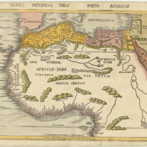
Exceptional example of one of the earliest maps to focus on the entire continent of Africa
Totius Africae tabula, & descriptio universalis, etiam ultra Ptolemaei limites extensa.
Out of stock
Description
Lovely map of Africa based on Ptolemy, with a distinct river system and mountain ranges. This geography is augmented from Portuguese and Arabic sources, from which comes Caput Bonespei (Cape of Good Hope) and a small group of islands off the eastern coast named Zaphala Aurifodina that were supposedly the region from which King Solomon imported gold and silver. The coastal outline of Africa had only recently been understood by Europeans. Bartolomeo Dias rounded the Cape of Good Hope in 1488, while Vasco de Gama reached India by sea a decade later.
The Arab kingdoms of Quiola and Melinde appear in eastern Africa and Hamarich, the capital of the mythical Christian king Prester John, is shown at the confluence of the twin sources of the Nile.
The island of Madagascar is strangely absent, even though its presence was known from the time of Marco Polo.
The map is illustrated with crowns and scepters indicating kingdoms, forests, parrots, an elephant, and a large galleon under full sail. In what is today Nigeria and Cameroon, there is a Cyclops or one eyed man, a reference to the fabled tribe of the Monoculi.
Cartographer(s):
Sebastian Münster (1488-1552) was a cosmographer and professor of Hebrew who taught at Tübingen, Heidelberg, and Basel. He settled in Basel in 1529 and died there, of the plague, in 1552. Münster was a networking specialist and stood at the center of a large network of scholars from whom he obtained geographic descriptions, maps, and directions.
As a young man, Münster joined the Franciscan order, in which he became a priest. He studied geography at Tübingen, graduating in 1518. Shortly thereafter, he moved to Basel for the first time, where he published a Hebrew grammar, one of the first books in Hebrew published in Germany. In 1521, Münster moved to Heidelberg, where he continued to publish Hebrew texts and the first German books in Aramaic. After converting to Protestantism in 1529, he took over the chair of Hebrew at Basel, where he published his main Hebrew work, a two-volume Old Testament with a Latin translation.
Münster published his first known map, a map of Germany, in 1525. Three years later, he released a treatise on sundials. But it would not be until 1540 that he published his first cartographic tour de force: the Geographia universalis vetus et nova, an updated edition of Ptolemy’s Geography. In addition to the Ptolemaic maps, Münster added 21 modern maps. Among Münster’s innovations was the inclusion of map for each continent, a concept that would influence Abraham Ortelius and other early atlas makers in the decades to come. The Geographia was reprinted in 1542, 1545, and 1552.
Münster’s masterpiece was nevertheless his Cosmographia universalis. First published in 1544, the book was reissued in at least 35 editions by 1628. It was the first German-language description of the world and contained 471 woodcuts and 26 maps over six volumes. The Cosmographia was widely used in the sixteenth and seventeenth centuries and many of its maps were adopted and modified over time, making Münster an influential cornerstone of geographical thought for generations.
Condition Description
Early manuscript additions in the right margin.
References
Norwich 2.
![[South Africa] Photograph panorama of Cape Town, c. 1870](https://neatlinemaps.com/wp-content/uploads/2022/09/Screen-Shot-2022-12-18-at-11.22.15-AM-300x300.png)