A separately-issued rarity of Africa by Pierre Duval.
L’Afrique Par le Sieur Du Val, Geographe Ord. du Roy
$2,000
1 in stock
Description
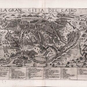
This unusual map by Pierre Duval is a comprehensive and detailed presentation of Africa, achieved by dividing the sheet up into what is in essence 15 different maps: one map of the entire African continent along with 14 regional maps.
The regional maps show Egypt (L’Egypte), Northwest Africa (Numidie), West Africa (La Nigritie), a long horizontal view of North Africa (La Barbarie), Southeast Africa (Monomotapa), South Africa (La Cafrerie), the Horn of Africa (Le Languebar), Abyssinia (L’Abissinie), Congo, Nubia, Terceira Island and the Azores, the Canary Islands, the Cape Verde Islands and Madagascar. Each includes a short description of the people, geography, and/or political situation of the region.
Betz relates that this map is part of a set of four continent maps with regional maps produced by Duval, dated to circa 1656 based on the map of the Americas. This is the third state of the Africa map, with the visible erase of Laignet sur le quay de la Megisserie au fort leuseq from the title. It is undated but likely dates to the early 1660s. The verso is blank, as it is for all three states.
An extremely rare and interesting piece for serious collectors of Africa.
Cartographer(s):
Pierre Du Val (1619–1683) was a prominent French geographer and mapmaker during the 17th century. Born in Abbeville, he was the son-in-law of the famous French cartographer Nicolas Sanson, often regarded as the founder of modern French cartography. Under Sanson’s tutelage, Du Val gained access to extensive geographical knowledge and advanced cartographic techniques, allowing him to develop his reputation in the field. His early work drew heavily from Sanson’s methods, but Du Val quickly distinguished himself through his meticulous attention to detail and the aesthetic quality of his maps.
Du Val became the official geographer to King Louis XIV in 1650, a prestigious role that placed him at the center of French mapmaking during an era of significant exploration and colonial expansion. He produced a wide array of maps, including regional maps of Europe, detailed globes, and thematic maps that covered subjects such as travel routes and fortifications. His works were celebrated for their accuracy and beauty, helping to elevate French cartography to international prominence. In addition to his maps, Du Val also published atlases and instructional materials, contributing to the education of future generations of geographers and explorers.
Condition Description
Excellent.
References
Richard L. Betz, The Mapping of Africa: a Cartobibliography of Printed Maps of the African Continent to 1700 ('t Goy-Houten: Hes & De Graaf, 2007), #85.3.