Large-format post WWII Metsker map of the Bay Area.
Metsker’s Map of San Francisco Bay District California
Out of stock
Cartographer(s):
Charles F. Metsker
Date:
ca. 1946
Place:
San Francisco
Dimensions:
62 x 108 cm (24.5 x 42.5 in)
Add to Wishlist
Add to Wishlist
Description
This detailed folding map of the Bay Area stretches south past San Jose to Ben Lomond, north to Napa, and east-west from Pleasanton to the Pacific Ocean. It is a fine and attractive product of the famous firm of “Metsker the Map Man.” Lots of interesting natural and cultural detail from an era before much of the Bay Area saw major expansion.
Cartographer(s):
Condition Description
Wear along the folds, especially at bottom fold.
References
OCLC Number 78892742.
Related products
-
-
Add to cart
- San Francisco, Railroad Maps
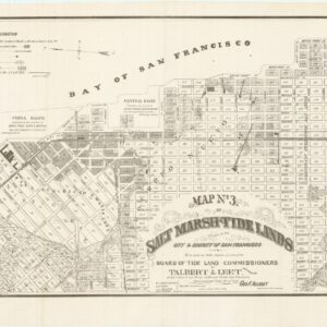
Map no. 3. Salt marsh and tide lands situate in the city and county of San Francisco. To be sold at public auction by order of the Board of Tide Land Commissioners by Talbert & Leet, auctioneers, at their sales rooms no. 526 California Street, San Francisco. Sale to commence Friday Nov. 26th, 1869.
- $3,400
-
-
-

![[1906 EARTHQUAKE PANORAMA – FINANCIAL DISTRICT]](https://neatlinemaps.com/wp-content/uploads/2020/10/Screen-Shot-2023-02-06-at-6.55.56-PM-300x300.png)