A variation on Arrowsmith’s Western Hemisphere.
Amerique reduite d’apres celle d’Arrowsmith…
$475
In stock
Description
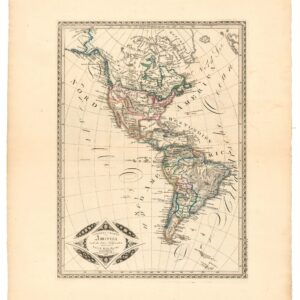
The 1854 state of a seminal French chart of the Western Hemisphere showcasing a new method of projection and capturing the creation of the United States we know it.
This lovely map, entitled Amerique Reduite d’Apres Celle d’Arrowsmith, is a visual testament to the precision of cartography in the 19th century. It was compiled and crafted by J.N. Champion and originally published in 1813. Champion drew directly on two great sources of popular cartographic information, both acknowledged on the map. From the title, we learn that the template is based on Aaron Arrowsmith’s original from 1799. However, unlike Arrowsmith’s globular projection, Champion applies the pseudo-cylindrical Mollweide projection, a wholly new method of projection that had only been invented in 1805.
Champion’s other great source of information – acknowledged in the map’s subtitle – regards using Alexander von Humboldt’s astronomical observations. The subtitle also emphasizes that this state of the map was augmented using the latest discoveries of intrepid explorers such as Lewis and Clarke, Zebulon Pike, John Franklin, and William Edward Parry. Their explicit inclusion of the title was not only to honor these heroes but served to underline that this product captured the latest developments in science and exploration – even though it was drawn from an established template.
The map offers a treasure trove of geographical information. In North America, the United States is portrayed in a familiar form, featuring well-defined Missouri and Oregon Territories, complete with the names of numerous indigenous tribes and many settlements. Unlike earlier versions of the map, the 1854 state shows Texas fully integrated as a state, just as the territories won in the Treaty of Guadalupe Hidalgo (1848) are shown as part and parcel of the United States.
While America is recognizable, the fact that it was still evolving is reflected in the labeling of Alaska as Amerique Russe, recalling the significant Russian presence in the Northwest Pacific. The map offers a wealth of detail in North and South America, showcasing an array of towns, cities, rivers, and topographical features. The extensive representation of South Pacific islands, each carefully located and meticulously identified, adds an exotic flair.
Census
The map was originally published in Paris in 1813 by Hyacinthe Langlois and was issued in at least three separate editions by at least two different publishers (1815, 1828, and 1854). Neatline’s example is the latest state, which dates 1854 and is published by Bes & Dubreuil in Paris, but for A.R. Fremin, from the Depot de la Guerre (war ministry). Unlike earlier examples of this map, this pristine copy remains unsliced, presenting itself as a single, full sheet that beckons exploration.
The Bibliotheque nationale de France in Paris is the only institution in which the OCLC has registered an example of this state of the map (no. 494924963).
Cartographer(s):
Condition Description
Verso stamped. Some minor wear visible.
References