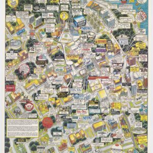
An intricate 1976 axonometric view of San Francisco — the first example we have ever seen for sale.
A bird’s-eye panoramic map of San Francisco
Out of stock
Description
A stunning achievement of design and cartography, this is a 1976 aerial view map of San Francisco, published by The Picture Map Company and drawn by John Tomlinson. Examples of this view are held in a variety of institutional collections, but we find no record of it previously for sale on the antiquarian map market.
Tomlinson’s view features an innovative aesthetic that seems to originate from the eye of an architect. The map was executed in elegant black-and-white, in contrast to the popular style of this era and genre, for example, this 1974 Hollmann Publishing Company map with similar extents. The framing of the view is geometric, with a series of bands and rectangular medallions in each corner. At top, we find two stylish inset panoramas. On the left side is “the view from Coit Tower,” including the San Francisco portion of the Bay Bridge, the Ferry Building, and part of the financial district with the Transamerica Building — the city’s most recognizable high rise structure.
To the right, we find another panorama, the view “from Bay Bridge to Golden Gate Bridge,” which stretches from the Ferry Building across Telegraph Hill to Russian and Nob Hills, Pacific Heights, and part of the Golden Gate. The views are segmented into window frames and flanked by columns, again exhibiting an architectural and schematic quality that we find wholly unique.
The map itself is a fantastic representation of San Francisco’s financial district and the core of its downtown and waterfront, with parts of Van Ness Avenue and Market Street (for a complete understanding of its scope, see this georeferenced image at the David Rumsey Map Collection). It is oriented slightly northwest on an axonometric projection, with each building rendered in 3-D, and many labeled. The mapmaker has successfully captured the natural topography of San Francisco’s famous hills, undulating up and down, with cable car lines along some of the steepest sections. The map includes much of Chinatown, North Beach, and Telegraph Hill, depicting its monuments, parks, and churches, as well as famous cultural landmarks like City Lights and Vesuvios.
Further south, past Union Square and the electric streetcars traveling up and down Market Street, there is an inset of the San Francisco Civic Center, with City Hall, the Opera House, and the SF Public Library building (the Asian Art Museum relocated here only in 2003). Beneath the inset we read “these blocks have been vacated for the proposed Yerba Buena Center,” a reference to San Francisco’s glossy center for the arts and gardens, which opened in 1993. In this way, the view tells the story of just how much the city has changed in the nearly fifty years since its publication, the most dramatic example of course being the existence on the map of the Embarcadero Freeway, which was demolished after suffering damages in the 1989 Loma Prieta Earthquake.
Overall then, this is a rare and captivating visualization of San Francisco as it was.
Cartographer(s):
Condition Description
Very good.
References
Rumsey 11331.000.


