The birth of the American Riviera.
Santa Barbara.
Out of stock
Description
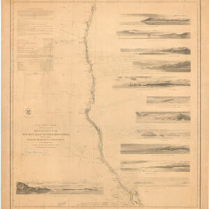
A hand-colored c. 1881 nautical chart of the waters off Santa Barbara, California by James Imray & Son.
Soundings, notes on bottoms, magnetic variations, and illustrations of seaweed line the city’s shoreline. On land, the mission and town of Santa Barbara can be seen, with individual buildings illustrated. Subsequent urban development has somewhat reshaped the landscape, but the remnants of the Arroyo del Pedregoso seen here remain with today’s Mission Creek.
At the time this chart was published, Santa Barbara had developed a reputation as a health resort for convalescents, a marked improvement over its earlier reputation as a lawless Wild West town. Improvements such as an opera house, gas lighting, and modern hotels made it easier for boosters (including the Southern Pacific Railroad) to pitch the town’s benefits to easterners.
The completion in 1872 of a wharf (curiously absent here) allowed for larger ships (steamships) to dock at Santa Barbara, and soon afterwards, in 1887, the city was linked with Los Angeles by rail.
Cartographer(s):
James Imray (May 16, 1803 – November 15, 1870) was a Scottish chartmaker and publisher whose firm produced an extensive list of so-called ‘blue-backed charts’ and pilot books. His son, James Frederick Imray, joined the firm in 1854, at which time it became known as James Imray & Son, which continued to publish charts after its founder’s death.
Condition Description
Some foxing. Fold lines visible.
References