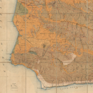
The earliest acquirable map of the bay of San Diego.
Plan of the Port of S. Diego in California. / Plan of the Port and Deparetement of S. Blas.
$500
In stock
Description
This is the rare English edition of what is the earliest acquirable map of San Diego. The engraved double-map, titled PLAN of the Port of S. DIEGO in California and Plan of the Port and Department of S. BLAS, comes from the English language edition of the iconic expedition by French explorer Jean-Francois de Galoup, Comte de La Perouse, who was sent by Louis XVI to explore the Western Pacific following the stunning discoveries of Captain Cook in the 1770s.
Even though they were published as part of the La Perouse expedition (1798), these two nautical maps were, in fact, based on the surveys conducted by Juan Pantoja, a Spanish captain involved in the Manila trade during the late 18th century. Like most Spanish Manilla traders, the focal point of Pantoja’s operations was San Blas, which was the most important depot on Mexico’s Pacific coast. From here, Pantoja not only sailed the Pacific but also conducted numerous supply runs along the west coast of North America, stopping in key locations such as the San Diego, Monterrey, and San Francisco Bays to conduct nautical surveys and provide support to the local Spanish missions. From the dates on these two particular maps – 1782 and 1777, respectively – it is clear that the surveys they were built on were completed long before La Perouse set off on his fateful voyage and that Pantujo’s efforts extended over the course of at least five years.
While Pantoja planned to have his surveys sent to Madrid so that the new data could be incorporated onto Spanish maps, he also appears to have shared his pioneering work with La Perouse, who meticulously copied Pantujo’s charts and annotations. Yet even though the fruits of Pantujo’s labors largely were disseminated through the publication of La Perouse’s voyage, it is unclear what parts of the West Coast the French actually sailed on. Certainly, La Perouse’s heavy and exclusive reliance on Pantoja’s manuscript charts dispels any notion that the French conducted their surveys. Even so, the map includes many accurate and vital observations. Most notably, it features the Presidio, several ranchos, and the landing described by Richard Henry Dana in his book “Two Years Before the Mast (1840).
Ironically, both men died before their works were published, so the exact relationship between them and their maps remains speculative. Regardless, the La Perouse map constitutes the earliest obtainable printed map of San Diego and a seminal accomplishment in the early cartography of California. It is only preceded by a handful of exceedingly rare maps, such as Dalrymple (1789).
Context is Everything
Between 1785 and 1788, French explorer Jean-Francois de Galoup, Comte de La Perouse, commanded an expedition to the still largely unknown Pacific Ocean. The goal was to complete the illustrious explorations that Captain James Cook had set in motion on this third voyage. La Perouse was recognized as one of France’s best naval commanders and was chosen for the job by King Louis XVI himself.
La Perouse first explored the coasts of Alaska and the Pacific Northwest, partly searching for the fabled Northwest Passage. Among his briefs was also the determination of correct longitudes, and the British Admiralty had supplied the French expedition with their data and instruments to solve this lingering problem.
After leaving North America, the expeditionary force crossed the Pacific to reach the Philippines. From here, they continued to the Asian mainland, where the entire coastal stretch from Macao to Kamchatka was investigated. Returning south, La Perouse sailed on the remote Solomon Islands. The last time anyone heard of the expedition was in Australia’s Botany Bay, where a British ship was provided copies of their records and packaged materials to be returned to Paris. This was in the spring of 1788. After that, the expedition was never heard from again.
La Perouse’s voyage is still considered one of history’s most incredible feats of exploration. Part of the reason why it is so celebrated is that despite the expedition’s disappearance, much of the information that they had accumulated throughout their journey was saved through a meticulous practice of copying records and sending copies back to France whenever the opportunity presented itself.
Census
This map was taken from VOYAGE ROUND THE WORLD performed in the years 1785, 1786, 1787, and 1788 by the Boussole and Astrolabe by Jean-Francois de Galaup La Perouse, a French Naval Officer and explorer. It is the earliest obtainable map of the Bay of San Diego, with earlier maps, such as that of Darymple (1789), being unobtainable on the open market.
After it was clear that La Perouse’s expedition had been lost, the French Government published the results and narratives that had made it back to France. Due to collaboration with the British Admiralty and an overwhelming public interest in Great Britain, an English edition was published in London a year after the French edition (1797). Neatline’s example of this map comes from this first English edition.
The OCLC lists many institutional holdings of the complete publication of La Perouse’s voyage in English (no. 85800166). Individual sheets of this particular map are also listed in the OCLC. In the US, examples of this map from the original French publication are held at the University of San Diego, San Francisco’s Maritime Research Center, and in the library of the Museum New Mexico (OCLC no. 6671276). Another example of the French version of this map is held in the Biblioteca Nacional de Espanha (OCLC no. 431781466).
Cartographer(s):
G.G. & J. Robinson were Scottish publishers based in London and active at the end of the 18th century and the beginning of the 19th century.
La Pérouse, Jean François de Galaup deJean François de Galaup, comte de Lapérouse (23 August 1741 – 1788 ca.) was a French Naval officer and explorer whose famous expedition vanished in Oceania. His naval career began when he entered the French Navy college in Brest at the age of fifteen. Over the years, he participated in various naval campaigns, among other things, earning the esteemed rank of Commodore for his victory over the English frigate ARIEL in the West Indies. He also played a significant role in the Battle of the Saintes and gained recognition by capturing two English forts along the coast of Hudson Bay.
In 1785, La Perouse was appointed to lead an expedition around the world by Louis XVI and his Secretary of the Navy, the Marquis de Castries. The aims of the expedition were quite ambitious, intending to sail and map regions such as Chile, Hawaii, Alaska, California, East Asia, Japan, Russia, Australia, and the South Pacific. The entire expedition vanished mysteriously after leaving New South Wales in March 1788. They were en route to New Caledonia, the Solomons, and the western and southern coasts of Australia. No member of the expedition was ever heard from again.
Condition Description
Very good. Minor foxing.
References