The first national mapping of Pakistan – published in Karachi.
Pakistan.
Out of stock
Description
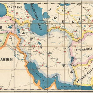
Mapping has always been about transferring an idea of regional unity (or disunity) to paper. In this early and iconic map of Pakistan, one senses a nationalistic fervor so palpably that it becomes the defining factor of this map.
This is an early, seemingly first-edition map of Pakistan that was issued for the first time in 1950, shortly after the country had achieved independence from first Great Britain and, subsequently, India. It was produced by the Department of Films and Publications, based on older surveys conducted by British, Indian, and Pakistani expeditions, and was formally approved by Pakistan’s new Surveyor General.
Among the many interesting aspects of this map, the most dominant is its nature as a nationalistic project, meant to cast Jinnah’s new nation as an equal among its peers. Having been created on the basis of Muslim majorities within Greater India, Pakistan was, to a degree, a fractured nation, divided into two major regions separated by a thousand miles of the tallest mountain range on Earth.
The main map depicts what back then was called West Pakistan, which corresponded roughly to what constitutes the country today. A number of inset maps nevertheless underscore that there is more to Pakistan than this. The most important addition is East Pakistan, seen in the lower right corner of the sheet and corresponding more or less to the modern nation-state of Bangladesh (for more on their separation, see the context section below).
In addition to presenting Pakistan as a coherent and legitimate state, the map also served to make a number of Pakistan’s territorial claims explicit. Most of these were disputed by neighboring India. Kashmir was and is at the heart of this conflict, and one quickly notices how the mapmaker has been deliberately careful in this northernmost region of the country. The fixed borders are vague and do not extend too deeply into Kashmir, while thick red lettering manifests that this is indeed a disputed territory. Even today, India and Pakistan cannot come to an agreement about this region, and the world shudders every time the cold war in the Himalayas turns hot. The Pakistani government’s changing perspectives on the Kashmir issue become more tangible when one compares Neatline’s early example of this pioneering map with later editions. In the fifth iteration from 1966, for example, we see large swathes of the Province of Kashmir fully incorporated into the country.
In many ways, this cartographic usurpation is not surprising. The Survey of India was doing exactly the same thing for India in the 1960s and beyond. The more surprising element in both this original rendition, as well as in later states of the map, is the inclusion of Junagadh and Manavadar as part of Pakistan (second inset map in the lower right corner). These previously princely states were situated on the Kathiawar Peninsula in Gujarat, hundreds of miles southeast of the Pakistani border. This, too, was disputed territory, but while Jammu and Kashmir were the obvious conflict zones growing out of the partition of India, the accession of Junagadh to Pakistan was a far more strained and contentious claim.
Context is Everything
Pakistan emerged in 1947 as a solution to the demand for a separate Muslim homeland in British India. Led by Muhammad Ali Jinnah, the nation faced immediate hurdles: Mass migration of Hindus and Sikhs to India, and a corresponding influx of Muslims to Pakistan, ignited communal violence and claimed millions of lives. Once independent, Pakistan became entrenched in repeated political upheavals and military coups but also in a relentless pursuit of democratic governance. The first two decades saw military dominance, with General Ayub Khan seizing power as president in 1958 and not relinquishing it until more than a decade later in 1969. Despite economic progress, discontent brewed, sparking widespread protests and demands for democracy. In 1971, Pakistan suffered a devastating blow as East Pakistan, now Bangladesh, declared independence after a brutal civil war.
Conflict in Kashmir
Pakistani independence has generally been characterized by a turbulent relationship with India, marked especially by the recurring conflicts over the territory of Kashmir. The princely state of Jammu and Kashmir was under the rule of Maharaja Hari Singh when India won its independence in 1947. It was a predominantly Muslim state, but the ruling dynasty, and a significant minority, were Hindu. Due to its mixed composition, Hari Singh saw Kashmiri independence as the most viable alternative to acceding to India, which really was his preferred choice. When Pakistan tried to force the issue by fomenting unrest and tacitly supported an invasion by Pashtun tribesmen, the Maharaja formally acceded to India in return for Indian military support to repel the invaders. This led to the first Indo-Pakistan war in 1947. After the war ended, part of Jammu and Kashmir remained under Pakistani control as Azad Kashmir, while the rest of the region continued to be disputed.
Since then, Pakistan’s relentless pursuit of nuclear weapons heightened tensions both domestically and globally. Throughout the 1960s, 70s, and 80s (and even during the tumultuous years of the 2000’), Pakistan grappled with intermittent military dictatorships and fleeting democratic governments unable to establish stable governance and address economic disparities. In the case of Kashmir, the United Nations has repeatedly tried to intervene in the conflict between India and Pakistan, but to little avail. Kashmir will likely remain a contested region for the foreseeable future.
Census
This map was first produced in 1950 by the Surveyor General of Pakistan and released as a cartographic manifestation of Pakistani independence. As is often the case with maps, it was a document of such crucial symbolic and national importance that it was updated and re-printed in at least five different states by 1966.
The Survey of India produced several maps of Pakistan in 1950, making exact identification difficult. However, the OCLC lists the English language map fo Pakistan by the Survey Office as figuring in six editions across twenty institutions worldwide (OCLC no. 48596052).
Cartographer(s):
Condition Description
Very good. Small area of loss at top-left corner.
References