After the Gold Rush.
Map of California and Nevada (Atlas of the United States)
Out of stock
Description
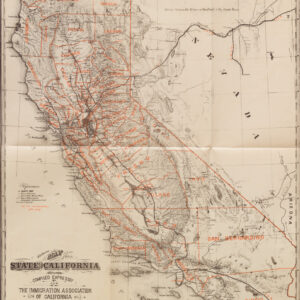
A lovely example of Warner and Beers 1872 hand-colored county map of California and Nevada, depicting them in the wake of the gold rush and in the midst of a subsequent silver rush, with mining operations in Nevada financed from San Francisco.
Counties are color-shaded for easy distinction. Towns and cities (some with their date of foundation noted), Native American groups, railroads, waterways, telegraph lines, wagon routes, mines, ranches, forts, elevation, terrain, and other features are indicated. Fascinating period details can be found throughout, including short-lived communities that would later become ghost towns, especially in gold country. But even in the San Francisco Bay region, multiple towns are displayed that would later change names (‘New York’ became Pittsburg) or cease to exist altogether (New Almaden, Scarsville, Paulta, and Urbon, to name a few).
Although California somewhat resembles it ultimate configuration, the map predates the creation of several counties, including Orange, Ventura, Imperial, and Riverside counties in Southern California. Much of the state’s interior, especially in the arid south and mountainous, heavily forested far north remained lightly settled and poorly understood by white settlers.
The geography of Nevada is similarly scant beyond the main rail and wagon routes. Of particular note is ‘Los Vegas’ in the state’s south and the ‘Old Mormon Fort’ there. This was the first non-native settlement in the region, established in 1855, and was the historical basis for Las Vegas when the city was incorporated in 1911.
Census
This map was prepared by Warner and Beers for the 1872 edition of the Atlas of The United States, published by H.H. Lloyd and Co. It can be distinguished from other editions of the map by the title text, page number at top-right, and geographic details of the map itself. This edition of the map is only independently cataloged among the holdings of the University of Iowa (OCLC 830325547) and the David Rumsey Historical Map Collection (List No. 2585.077) and is fairly scarce to the market.
Cartographer(s):
Warner and Beers were two families of map publishers who collaborated frequently in the late 19th century. They are particularly known for atlas maps of localities (counties, town, neighborhoods of cities), which were incredibly detailed and consequently have become a valuable resource for historians and genealogists.
Condition Description
Toning and soiling along edge and in margins. Repaired tear at right towards top, extending nearly 3 in. into image.
References