A unique 1939 full-page San Francisco Chronicle bird’s-eye-view for the Golden Gate International Exposition.
February 17, 1939 San Francisco Chronicle Map.
Out of stock
Description
This is a fantastic bird’s-eye-view seen from a point high above the East Bay. Looking west, we see the recently-completed Bay Bridge and Treasure Island in the foreground, then downtown San Francisco on to the Pacific Ocean with the Golden Gate Bridge and parts of Marin County.
The map was created in connection to the Golden Gate International Exposition (GGIE), a major world’s fair held on Treasure Island in San Francisco Bay, California, from February 18 to September 29, 1939. The event was organized to celebrate the completion of two significant engineering projects: the San Francisco-Oakland Bay Bridge and the Golden Gate Bridge.
The view is clearly the work of a skilled illustrator. It is signed ‘Magill,’ but we haven’t been able to locate any information on who this is. He or she successfully captures San Francisco’s famous topography and its prominent landmarks and important buildings. City Hall, the Golden Gate Bridge, the Ferry Building, and the Coit Tower are depicted.
Overall, an exciting piece of San Francisco ephemera.
Cartographer(s):
Condition Description
Newspaper print. Worn with small tears along edges.
References
Related products
-
-
Add to cart
- San Francisco, Railroad Maps
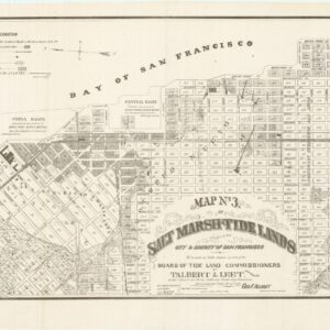
Map no. 3. Salt marsh and tide lands situate in the city and county of San Francisco. To be sold at public auction by order of the Board of Tide Land Commissioners by Talbert & Leet, auctioneers, at their sales rooms no. 526 California Street, San Francisco. Sale to commence Friday Nov. 26th, 1869.
- $3,400
-
-
-
![PORT OF SAN FRANCISCO. WHERE THE FAR EAST BEGINS [Japanese language version]](https://neatlinemaps.com/wp-content/uploads/2021/01/NL-00879_Thumbnail-300x300.jpg)
![[Sutro Baths] ON THE SHORE OF THE PACIFIC OCEAN](https://neatlinemaps.com/wp-content/uploads/2021/02/NL-00887_Thumbnail-300x300.jpg)