A unique Depression-era map set from a San Francisco Fire Department Fireboat.
Fire Boat No. 2. S.F.F.D.
Out of stock
Description
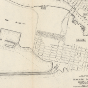
An extraordinary atlas of 11 San Francisco Fire Department maps published in 1931 under pioneering fire chief Charles J. Brennan.
The set of maps is complete and bound in its original black canvas folder. The folder, in turn, rolls into an original leather embossed tube labeled Fire Boat No. 2 S.F.F.D. in distinct black lettering. The water-resistant materials indicate that this atlas would have been kept on the fireboat, presumably as part of its official inventory. It is a fascinating survival of Depression-era cartography for one of America’s most important maritime cities.
Two steam-powered fire boats were put into active duty following the 1906 Earthquake: the David Scannel and the Dennis T. Sullivan (named after the SF Fire Brigade’s Chief Engineer, who was killed in the earthquake). Both fireboats were built by the Risdon Iron & Locomotive Company in San Francisco and launched in 1909. As our map book belongs to Fire Boat No. 2, we know it was from Dennis T. Sullivan, not the Scannel.
Each map is numbered (1-11), dated 1931, and labeled as coming from the office of Chief Engineer Charles J. Brennan. Brennan’s tenure as fire chief (1929-1943) left an enduring impact on fire safety and emergency response in San Francisco. Brennan assumed the role of Chief Engineer in November 1929 amidst the economic upheaval of the Great Depression. Tasked with steering the S.F. Fire Department through turbulent financial waters, Brennan proactively reorganized and fortified its structure despite stringent budget constraints and spearheaded modernization efforts.
This atlas reflects Brennan’s efforts to create reliable fire infrastructure maps designed to be kept on fire-fighting units. The maps cover the area from today’s Marina District and Fort Mason, the Embarcadero, and down to Islais Creek. The scope extends across most of the San Francisco peninsula, including the eastern part of Golden Gate Park and as far south as Twin Peaks (which has a reservoir) and Bernal Heights. Each map shows a distinct area and includes features such as hydraulic infrastructure (cisterns, pumps, hydrants, water mains, distribution stations, and gate valves) and the delineation of dedicated zones within the city.
San Francisco’s Pioneering Auxiliary Water Supply System (AWSS)
An interesting feature of the maps is the distinction of “infirm” areas. This designation is related to the city’s Auxiliary Water Supply System (AWSS), a network of pipelines built to withstand a giant earthquake that would be used exclusively for firefighting and was wholly separated from the regular water supply pipelines. The AWSS was constructed after the 1906 Earthquake, a calamity dramatically worsened by the buckling of water mains, leaving the Fire Department without water, with the exception of the Mission District, where a separate well-fed water supply allowed fires to be suppressed relatively quickly. The new extra-robust pipeline system built after the earthquake and fire used fresh water from the city’s reservoirs and tanks (especially Twin Peaks) and an unlimited supply of saltwater.
The new system was implemented in 1913 and included tied rods, preventing the underground water mains from being pulled apart during an earthquake. While constructing the AWSS, areas susceptible to liquefaction were identified. These are either the naturally sandy areas or, worse, the infilled areas of downtown. Liquefaction is strong enough to break the AWSS (as happened in the Marina area during the Loma Prieta Earthquake in 1989). Infirm Areas were thus the zones in which the fire department expected even reinforced water aims to break during a violent tremor. In these places, auxiliary systems operated with motors were gradually built.
Even today, old fire hydrants around SF reveal whether they are part of the drinking water supply (white tops) or the AWSS (black, red, or blue tops).
Census
This atlas is entirely unrecorded. We assume a single copy was made for each fireboat, and others were held at firehouses, without the special tube. It is unclear to what extent such a set was unique to San Francisco. Cities like New York, Seattle, and Vancouver have all employed fireboats, but no records of equivalent map books exist. San Francisco was a particular case because of its disaster history and because it addressed that history by constructing an advanced system that produced a consistent high-pressure water supply. In this sense, the city’s firefighting set-up was unique.
Likewise, it is unclear which maps the San Francisco Fire Department used before compiling Brennan’s maps. The most likely source was Sanborn Insurance Maps.
The initials S.A.R. at the bottom right corner of each map presumably indicate the printer, but we have yet to find a match.
Cartographer(s):
Condition Description
Good. Bound and rolled in leather covers. Some chips along edges of maps.
References
![PORT OF SAN FRANCISCO. WHERE THE FAR EAST BEGINS [Japanese language version]](https://neatlinemaps.com/wp-content/uploads/2021/01/NL-00879_Thumbnail-300x300.jpg)
![PORT OF SAN FRANCISCO. WHERE THE FAR EAST BEGINS [Japanese language version]](https://neatlinemaps.com/wp-content/uploads/2021/01/NL-00879_Thumbnail.jpg)