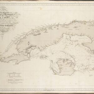
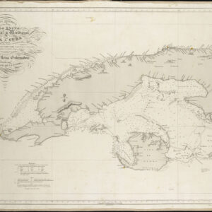
Nicolosi’s monumental and ground-breaking 4-sheet map of South America.
Peru Descriptore [incl. Hispania Descripta Secundum Tres Coronas] Auctore Joanne Baptista Nicolosio.
Out of stock
Description
This rare and monumental chart of South America comes from one of the finest cartographic endeavors of the 17th century. It was compiled by Giovanni Battista Nicolosi for his Dell’ Ercole e Studio Geografico and published in Rome in 1660. The map consists of four individually printed sheets and provides one of the most accurate and up-to-date depictions of South America produced anywhere outside Spain until that point.
Among the most protruding features of Nicolosi’s dramatic chart is that the continent has been depicted with south facing up, giving modern viewers the impression of South America being upside down. Moving clockwise from the lower left sheet, including the map’s title, each sheet depicts the following:
Sheet 1 depicts the easternmost part of South America, more or less corresponding to the Portuguese colony of Brazil. A series of rivers connect the vast and empty interior to a small but increasing number of riverine and coastal settlements. Among these, we find recognizable Brazilian towns like Recife, Pernambuco, Salvador, Port Seguro, and Spirito Santo. The old Dutch settlement at Paraiba is also shown, though no connection to the Dutch is made. In the lower right corner of the sheet, we note the enormous estuary created by the discharge of the Amazon River into the Atlantic, and in the lower left corner, we find a simple title cartouche.
Sheet 2 shows only a small section of the South American continent, depicting the Atlantic coast from Cabo San Sebastian and São Paolo to the Rio de la Plata. The mouth of the Rio de la Plata constituted one of South America’s most important locations in the 17th century and today forms the formal border between Argentina and Uruguay. Among the notable features surrounding this critical estuary is an early depiction of Buenos Aires (founded in 1580 by Juan de Garay). Inland, the sheet also includes parts of southern Brazil, also known as Rio Grande de Sul.
However, most of Sheet 2’s space has been used for a large and detailed inset of the Iberian Peninsula. In the 17th century, Spain constituted the leading colonial power in this vast territory, and Portugal completely controlled Brazil. The inset thus represents Europe’s colonial hegemony over distant and largely unknown regions.
Sheet 3 depicts the southern tip of South America, including significant stretches of Argentina, Chile, Patagonia, and a fully delineated Tierra del Fuego (Terra d Fuoco). The littoral and its southern tip are drawn in remarkable detail for the age, carefully capturing the Magellan and Le Maire Straits and many of the islands surrounding Cape Horn. We find all the expected features along the coast, including river estuaries, natural coves, harbors, and the first European settlements. Running like a spinal column through the interior is an evocative depiction of a massive cross-continental mountain range stretching into Patagonia. While this representation generally refers to the Andes, Nicolosi’s southern expansion is equipped with specific place names for distinct stretches of this chain (Sierra Nevadas in the far south and Pulches further north).
Sheet 4 captures the northwestern quadrant of the continent, including the key Spanish regions of Columbia, Venezuela, Ecuador, Peru, and, to some extent, Bolivia (note the presence of Lake Titicaca). This was the heartland of Spain’s empire in South America and undoubtedly the most explored and best-understood region under their control. This anchoring is reflected in the level of detail included in this quadrant vis-a-vis the other three. Cutting through the interior, we find a detailed rendition of the Amazon River and mythical features such as Lake Parima, which are consistent with the age in which Nicolosi worked. Among the many exotic locations on the map, we note an early depiction of the Galapagos Islands on the equator. We also note that the southernmost part of Central America created the land bridge between the two American continents.
Census
This is the first state of the map, issued in 1660. OCLC lists a limited number of institutional holdings of the first state of this map, including at the Biblioteca Nacional de Espanha (no. 1091676617), the Library of Congress, and Newberry Library in Chicago (no. 939536261).
Nicolosi and the Dell’ Ercole e Studio Geografico
Giovanni Battista Nicolosi (1610-1670) was a Sicilian priest and cartographer working for the Vatican in Rome. Motivated by the ground-breaking maps of French cartographer Nicolas Sanson (especially those in his 1653 Index Geographicus), the Propaganda Fide of Rome commissioned Nicolosi to produce an atlas that could rival Sanson’s. Over the next seven years, Nicolosi labored intensively to meet his employer’s demand, and the outcome would be one of the most essential Italian atlases produced in the 17th century.
Nicolosi’s Dell’ Ercole e Studio Geografico was published in Rome in 1660 and again in 1671 as a posthumous Latin edition. The title referred to a comparison between the labors of Hercules and those he had sustained to complete a full description of the earth. In the Ercole, Nicolosi presented large four-sheet maps of all the continents as they were known in the 1650s (Africa, North America, South America, Europe, and Asia – twenty-two plates in all). The atlas also contained an essential double map of the world, which incorporated many of the continental map innovations on a global scale (e.g., both the dubious depiction of the Niger River, as well as the first relatively accurate inclusion of the Rio Grande). Consequently, both the 4-sheet maps of the continents and the two-sheet map of the world have become highly sought after by collectors and institutions alike.
The Ercole was dedicated to Giovanni Battista Borghese and consisted of two folio volumes printed by Vitale Mascardi. Composed of no less than 22 maps with associated explanatory text, the Latin edition of the Ercole (1670) allowed Nicolosi’s ideas to be fully integrated into the cartographic mindset of Europe. In time, the Ercole became one of the most critical geographical works of the 17th century. This was partly because of the incredible archives and sources available to Vatican scholars in the 17th century. Still, the main reason was that Nicolosi approached global mapping in a novel way. He combined the traditions and perspectives of 16th-century Roman and Venetian mapmakers with the latest approaches of contemporary greats such as Nicolas Sanson. This amalgamation of traditions and styles meant that Nicolosi could come up with an entirely new way of portraying the world – especially when it came to larger landmasses where the curvature of the Earth affected how such terrain could be portrayed correctly.
Nicolosi was the first to employ the so-called pseudo-perspective projection in which the established meridians were perfected by complimenting circular parallels. Over the following decades, and especially during the early 18th century, this projection technique – also known as the globular projection – became increasingly popular and was applied by seminal cartographers such as Guillaume de l’Isle and Aaron Arrowsmith. In the decades after Nicolosi’s death, the globular or Nicolosi projection replaced the stereographic projection popularized by Mercator, which had increasingly fallen into disuse. During the 19th century, the Nicolosi perspective became the standard cartographic projection technique, and it remains in use today.
Cartographer(s):
Giovanni Battista Nicolosi (1610-1670), also known as Giovan Battista, was a Sicilian priest, geographer, and cartographer who worked for the Vatican’s Congregation for the Evangelization of Peoples (or Propaganda Fide) under Pope Gregory XV. Officially, the Fide office was established to promote missionary work across the globe. Still, the reality was that it constituted an essential office for the maintenance and dilation of the Church’s power in an ever-expanding world.
Arriving in the papal capital around 1640, Nicolosi studied letters, sciences, geography, and languages. In 1642, he published his Theory of the Terrestrial Globe, a small treatise on mathematical geography, and a few years later, his guide to geographic study was issued, a short treatise on cosmography and cartography. Both works reflected a Ptolemaic worldview, but his guide to geographic analysis would soon serve as an introduction to Nicolosi’s real magnum opus, Dell’ Ercole e Studio Geografico, first published in 1660. On the other hand, his Theory of the Terrestrial Globe brought Nicolosi to the attention of broader scientific circles. It earned him the Chair of Geography at the University of Rome. In late 1645, he traveled to Germany at the invitation of Ferdinand Maximilian of Baden-Baden, where he remained for several years until he returned to Rome. Here, Nicolosi was appointed chaplain of the Borghesiana in the Basilica of Santa Maria Maggiore. This honor was conferred on him by Prince Giovanni Battista Borghese, whom Nicolosi had tutored and in whose palace he had lived since 1651. Years later, Nicolosi would thank the prince for his generosity by dedicating his most seminal work to him.
A considerable collection of Nicolosi’s unpublished work exists in the Vatican and other national archives. This includes a large chorographic (i.e. descriptive) map of all of Christendom, commissioned by Pope Alexander VII, and a full geographic description and map of the Kingdom of Naples, which was sent to Habsburg Emperor Leopold I in 1654.
Condition Description
Very good. 4-sheets, unjoined.
References