Unrecorded 1849 Italian guide and history of Hungary published in Florence during the height of the Hungarian Revolution.
Cenni Geografico-Storici sull’Ungheria.
$975
1 in stock
Description
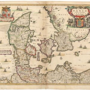
With an unusual folding map by one of Italy’s first lithographers.
This charming and scarce volume is an Italian guide and history of Hungary, printed by the Libreria Bettini in Florence in 1849. The timing of the volume is auspicious, as Hungary was in the midst of a nationalist revival and revolution that would be quelled by the year’s end.
The folding map at the back of the book was compiled specifically for this volume and has the distinct appearance of a manuscript map despite being an early form of lithograph. The map was produced in 1849 by a Florentine lithographer, Cosimo Ridolfi (1794-1865), who is identified in the lower-left corner. Ridolfi was one of the first printers to employ the lithographic technique in Italy, preceding the first lithographer in Rome by more than 12 years. He was an active publisher of printed matter throughout the mid-19th century and is known for publishing images of the contemporary Italian painter and engraver Luigi Giarrè (1772-1844).
The map is oriented to the cardinal points and primarily depicts the regions of Hungary, Croatia, and Slovenia, each delineated by colored borders. Rivers are highlighted in blue, while the remaining features are shown in the original printed black. The map’s scope extends from the western city of Graz (Gratz) to the Romanian capital, Bucharest. At the heart of it all are the Hungarian capital, Budapest, and Lake Balaton (Lago Platten).
The fact that this map was created during the revolution, yet at the height of the Austro-Hungarian Habsburg Empire, is evident in the use of German names for most towns and cities. German remained the official language of most of Central Europe in the mid-19th century, so one finds no place names in Hungarian, Croat, or other Central European languages.
Historical Context
The Hungarian Revolution of 1848-1849, also known as the Hungarian Civic Revolution or War of Independence, was part of the broader fan of European Revolutions and closely tied to other uprisings in the Habsburg territories.
The background to the Hungarian Revolution was that in April 1848, a democratic parliamentary election law was enacted in Hungary, making it only the third European country to adopt democratic reforms after France and Belgium. The new law transformed the feudal parliament into a representative body, extending voting rights more broadly than anywhere else in Europe at the time and eliminating the birthright privileges of the Hungarian nobility.
Soon, however, the new Austrian monarch, Franz Joseph I, arbitrarily revoked the April laws and engaged in a military campaign against the Hungarians. This led to the rescission of the reforms and to the fall of the pacifist Batthyány government and the rise of Lajos Kossuth’s followers, who sought complete independence for Hungary. When the Austrian military intervened, the conflict escalated and cemented strong anti-Habsburg sentiment among Hungarians. Soon, the call for autonomy sounded throughout the Empire.
Ultimately, a joint Russo-Austrian army defeated the Hungarian forces in 1849, restoring Habsburg power and imposing martial law on Hungary. Although unsuccessful, the Hungarian Revolution of 1848 remains a significant event in Hungary’s history and a cornerstone of its national identity.
Cartographer(s):
Cosimo Ridolfi (1794-1865) was a Florentine printer and publisher who was one of the first to introduce the lithographic technique to Italy.
Condition Description
Cover is in poor condition, text block nearly detached. The map has a few blemishes, but overall it is in good condition.
References