French government map of the economic resources and activities in a newly independent Middle East.
[Data Visualization] Moyen Orient. Essai de Carte économique.
Out of stock
Description
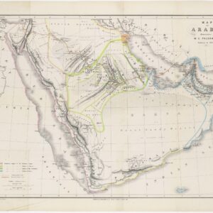
This French government map of the Middle East from 1958 was produced by the Secretariat Général du Government and printed by the Institut Geographique national in Paris. It is sheet map number 77 (corrected by hand from the printed number 79 on the verso) in a series of such maps produced by the French government following the global collapse of colonial rule in the wake of World War II. The map shows the entire Middle East and beyond, stretching in scope from Egypt in the west to Afghanistan in the east and including the entire Arabian Peninsula.
Two insets supplement the main map in the lower left and right corners. In the left corner, we are offered a somewhat schematic view of Arabia, the primary purpose of which was to delineate the interests of the emergent petroleum industry. In this sense, the mapmaker clarified that fossil fuels were already central to European and US interests in the region. On the lower right side is a far more detailed inset of the East Mediterranean coast, including the newly formed nations of Israel and Lebanon.
The entirety of the map is color-coded to underscore the economic dynamics of the region. A legend in the upper right corner elucidates the meaning of the different colors. Interestingly, these both refer to demographic compositions and cultivation possibilities (i.e., climatic zone and level of aridity), indicating that the French see a relationship between the two. The same legend also provides information on general population densities, transportation infrastructure, natural resources (primarily chemicals and ore), and active industries in the region.
In sum, this map presents the new way European economies understood the Middle East following the end of colonial rule. It is quite clear what drives French interests at this stage, just as the map makes it palpable that European nations – now in greater competition with one another than ever before – would not let the waning of their political influence impact new economic opportunities.
Cartographer(s):
Condition Description
Minor wear along folds.
References