The Royal French Geographer’s most prestigious rendition of Arabia and the Greater Middle East.
Carte Générale de la Turquie d’Asie, de la Perse, de l’Arabie, du Caboul er du Turkestan Indepedant.
Out of stock
Description
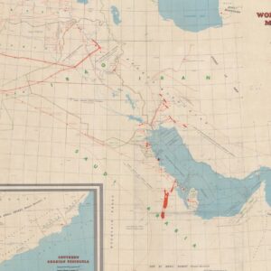
This stunning and highly detailed double-sheet of the Greater Middle East and Arabia was originally compiled by French Geographer Adrien Hubert Brué in 1826. Ten years later, it was revised and adapted for his big prestige project, the Atlas universel de géographie physique, politique, ancienne et moderne. However, unlike most other maps from Brué’s atlas, this particular chart was not included in the first expanded edition in 1830. Still, it was only completed for the more monumental 1840 edition from which Neatline’s sheet derives.
Like many of Brué’s maps, this chart was printed by Charles Piquet of Paris. Additional stamps next to the title cartouche inform us that the original prototype was compiled as early as 1822. In 1835, the French state acquired this, but soon, the Royal Geographer was working on it again. With the revisions completed in 1836, Brué had sufficiently updated his chart to be included in this grand atlas’ new and most monumental edition. For more on the publication history, see the census section below.
As is usually the case with Adrian Hubert Brué’s maps, the composition is extremely well done. Both the topography and infrastructure have been represented with an impressive level of accuracy. Cities, towns, and villages are clearly marked, as are roads, rivers, and other routes. The dramatic topography of the Middle East’s diverse landscapes is accentuated by hand-colored regional borders delineating political divisions.
For the Arabian Peninsula, it is clear that the density of toponyms and other inclusions is more limited than in the surrounding Fertile Crescent. However, especially along the Red Sea, we find many place names and details that derive from essential expeditions to the region in the late 18th century. Most crucial was the Danish expedition to Felix Arabia (1761-67), in which Carsten Niebuhr compiled the most accurate maps of both the Red Sea Basin and Yemen itself. Brue´s prestigious predecessor, Royal French Geographer Jean Baptiste Bourguignon D’Anville, later elaborated on these seminal maps.
In the Gulf, we find early depictions of the island of Bahrain, the coastal pearling town of Fereyha (Freihat), and even an early presence of the toponym for Qatar (Catura). Near the Strait of Hormuz is Djulfar, an important coastal trading town in East Arabia and today part of the United Arab Emirates (Ras al-Khaimah). Beyond the Arabian Peninsula, Brué is equally determined to provide as comprehensive a geographical overview as possible. Anatolia, Persia, Central Asia, and Greater Syria-Palestine are all rendered with impeccable detail.
In sum, Brué’s gorgeous double-page chart constitutes one the best cartographic captures of those parts of the world dominated by Islamic faith and culture.
Context is Everything
Adrien-Hubert Brué was a Royal Geographer during the July Monarchy (1830-1848), in which Louis Philippe I reigned as King of France. This period of relative calm followed the massive social upheavals of the French Revolution and the subsequent Napoleonic Wars.
As geographer to the King, Brué produced several vital maps and charts. Still, his most successful endeavor was the Atlas universel de géographie physique, politique, ancienne et moderne, from which this map derives. The original edition of the expanded atlas was issued in 1830, but a decade later, a second and enlarged edition was published. This edition saw several significant changes made to many of the maps inside – especially concerning the political configuration of North America. From this enlarged second edition of the atlas, our map of the East Mediterranean comes.
Census
The map was published in the second and enlarged edition of Brué’s Atlas universel de géographie physique, politique, ancienne et moderne, published in Paris in 1840. This edition of the atlas included 68 engraved maps, of which 67 were double-page sheets.
Brué’s maps were drawn directly onto the copper printing plates, and most of the sheets were subsequently hand-colored in outline. The atlas covered contemporary and historical geography, including maps of Alexander the Great’s Empire or the Route of Exodus. It was published multiple times and in different versions between 1820 and 1875, with the first enlarged version issued in 1840. Our map derives from this enlarged edition.
Cartographer(s):
Adrien Hubert Brué (1786-1832) was a French cartographer active in the 18th and 19th centuries. He was born in Paris on March 20, 1786, and died of cholera on July 16, 1832, in Sceaux.
In his youth, Brué served as a cabin boy on various ships, including aboard the Naturaliste, which was part of the Baudin expedition (1800-1804) to the South Seas and New Holland (Australia). Upon his return, he began producing maps for a grand atlas, published for the first time in 1820. A new and better atlas was issued in 1830, the same year he was appointed Royal Geographer.
Brué’s production included various atlases and unique maps, all of which were recognized for the purity of the engraving and the accuracy of the information. His main work, the Atlas universel was expanded multiple by him and Charles Picquet (whose stamp is found on most of Brué’s maps). Among the many aspects that elevated Brué above his peers was the. The fact that he drew his maps directly onto copper plates, a process which he named cartel end prototypes.
Charles PicquetCharles Picquet (1771-1821) was a French cartographer especially celebrated for his collaborations with Adrien-Hubert Brué.
Condition Description
Very good.
References
![[With Extensive Contemporary Annotations] Ordnance Survey of the Peninsula of Sinai Made in 1868-9.](https://neatlinemaps.com/wp-content/uploads/2020/05/NL-00842_Thumbnail-300x300.jpg)
![[With Extensive Contemporary Annotations] Ordnance Survey of the Peninsula of Sinai Made in 1868-9.](https://neatlinemaps.com/wp-content/uploads/2020/05/NL-00842-scaled.jpg)
![[With Extensive Contemporary Annotations] Ordnance Survey of the Peninsula of Sinai Made in 1868-9.](https://neatlinemaps.com/wp-content/uploads/2020/05/NL-00842-scaled-300x300.jpg)