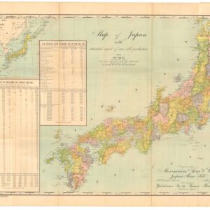
Brué’s map of two disintegrating Asian empires: Qing China and the isolationist Japan of the Tokugawa Shogunate.
Carte Génerale de l’Empire Chinois et du Japon.
Out of stock
Description
The lusciously detailed map of China and Japan was compiled by French royal geographer Adrien Hubert Brué in 1826 and then revised a decade later. Neatline’s example is essentially the modified state from 1836 but printed in an enlarged version for Brué’s monumental Atlas universel de géographie, published by Charles Piquet in 1840.
The map is incredibly detailed, with both coastal and inland regions carefully delineated and labeled. While the map’s focus is China and, to a lesser extent, Japan, the scope of the map extends to include large swathes of Central Asia and the Himalayas, including Tibet, Mongolia, and northern India. Among the many elements of historical interest, we find Manchuria still entirely controlled by a declining Qing Empire. While the Qing Dynasty originated in Manchuria, the expansive policies of Imperial Russia and the growing demographic power of the Han meant that Manchuria increasingly became contested. Within decades of this map’s production, Russia had encroached dramatically into this territory.
Another fascinating feature is that the map’s compilation immediately predates the First Opium War (1839-42), which entailed the British annexation of Hong Kong Island and a reconfiguration of power in the South China Sea. Indeed, the toponym Hong Kong is nowhere to be found on our map, while nearby Lantau Island and Portuguese-controlled Macau figure clearly. Following the example of the British in Hong Kong, the Portuguese would also cement their rule by formalizing Macau (and even expanding it territorially) as a colony.
The Japanese Empire depicted in this map is also exciting and time-specific. We are nearing the end of more than two and a half centuries of Tokugawa rule, with massive changes luring on the horizon. In 1853, Commodore Matthew Perry of the US Navy used his gunboats to impose an end to Japanese isolationism, thus ushering in an entirely new era of Japanese history. Brué’s map shows Japan on the cusp of that upheaval.
Cartographer(s):
Adrien Hubert Brué (1786-1832) was a French cartographer active in the 18th and 19th centuries. He was born in Paris on March 20, 1786, and died of cholera on July 16, 1832, in Sceaux.
In his youth, Brué served as a cabin boy on various ships, including aboard the Naturaliste, which was part of the Baudin expedition (1800-1804) to the South Seas and New Holland (Australia). Upon his return, he began producing maps for a grand atlas, published for the first time in 1820. A new and better atlas was issued in 1830, the same year he was appointed Royal Geographer.
Brué’s production included various atlases and unique maps, all of which were recognized for the purity of the engraving and the accuracy of the information. His main work, the Atlas universel was expanded multiple by him and Charles Picquet (whose stamp is found on most of Brué’s maps). Among the many aspects that elevated Brué above his peers was the. The fact that he drew his maps directly onto copper plates, a process which he named cartel end prototypes.
Charles PicquetCharles Picquet (1771-1821) was a French cartographer especially celebrated for his collaborations with Adrien-Hubert Brué.
Condition Description
Very good.
References