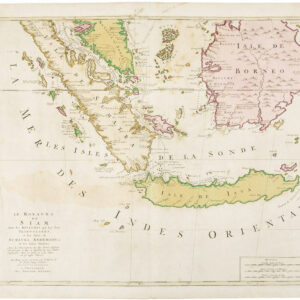
A stunning hand-colored chart of the East Indies, produced during the height of colonialism in Southeast Asia.
Carte du Grand Archipel d’Asie, Partie Nord-Ouest de l’Océanie.
$300
In stock
Description
This appealing copperplate engraving of the East Indies or Indonesian archipelago was first made by French royal geographer Adrien Hubert Brué in 1826. He issued a revised edition of the map in 1834, which then became Plate 48 in the enlarged version of Brué’s Atlas universel de géographie, published by Charles Piquet in 1840.
Once published, the map quickly became one of France’s best cartographic references for a politically and geographically complicated region that spanned from New Guinea to Burma. This scope is seen in the map, which also includes surrounding areas, such as the Philippines, Malaysia, and the northern coasts of Australia. The map provides an honest, albeit sparse, treatment of island interiors, where European understanding and presence were limited. It delineates the colonial affiliations of each island within this vast archipelago, which at the time was no simple matter.
The vibrant map captures this region’s physiography, toponymy, and political configuration in vivid detail. In addition to its enlarged size, one of the features enhancing the map’s aesthetic appeal is the original outline color that was applied by hand. Throughout the map, annotations reference everything from geographic features to native villages. At the same time, the highly variegated topography of these volcanic islands is shown through careful hachuring.
Also embedded in the map are the region’s recent political developments. The distinctive outline coloring was explicitly applied to delineate regional political affiliations. These are further explained in the legend in the lower left corner and include important colonial players such as the Dutch, the Portuguese, the Spanish, and the Sultanate of Sulu, as well as various indigenous rulers. We also find extensive notes providing information on Brué’s sources in its compilation.
Printed on heavy paper with wide margins, the map is one of the best and most aesthetically pleasing cartographic renditions of the Indonesian Archipelago of its day. It captures a distant but essential part of the world, just as Queen Victoria was about to ascend the British throne. She would inaugurate an entirely new era of exploration and cartography.
The map is conceptually linked to another vital map from Brué’s 1840 atlas, namely his double-age chart of Oceania.
Census
The map was published in the second and enlarged edition of Brué’s Atlas universel de géographie physique, politique, ancienne et moderne, published in Paris in 1840. This edition of the atlas included 68 engraved maps, of which 67 were double-page sheets. His maps were drawn directly onto the copper printing plates, and most of the sheets were subsequently hand-colored in outline. The atlas covered contemporary and historical geography, including maps of Alexander the Great’s Empire or the Route of Exodus. It was published multiple times and in different versions between 1820 and 1875, with the first enlarged version issued in 1840. It is from this enlarged edition that our map derives.
The OCLC notes several holdings of the original 1826 state (893943738) and the revised 1834 state (495077633). We have not identified any listings of the enlarged 1840 edition of the 1834 state, which is the example offered here.
Cartographer(s):
Adrien Hubert Brué (1786-1832) was a French cartographer active in the 18th and 19th centuries. He was born in Paris on March 20, 1786, and died of cholera on July 16, 1832, in Sceaux.
In his youth, Brué served as a cabin boy on various ships, including aboard the Naturaliste, which was part of the Baudin expedition (1800-1804) to the South Seas and New Holland (Australia). Upon his return, he began producing maps for a grand atlas, published for the first time in 1820. A new and better atlas was issued in 1830, the same year he was appointed Royal Geographer.
Brué’s production included various atlases and unique maps, all of which were recognized for the purity of the engraving and the accuracy of the information. His main work, the Atlas universel was expanded multiple by him and Charles Picquet (whose stamp is found on most of Brué’s maps). Among the many aspects that elevated Brué above his peers was the. The fact that he drew his maps directly onto copper plates, a process which he named cartel end prototypes.
Charles PicquetCharles Picquet (1771-1821) was a French cartographer especially celebrated for his collaborations with Adrien-Hubert Brué.
Condition Description
Very good.
References