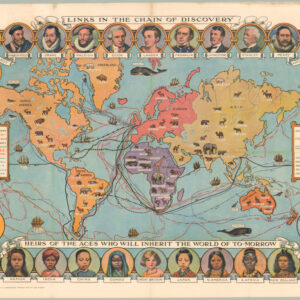
[Persuasive Cartography] German WWI propaganda map showing ‘England’s subjugation of the world.’
Karte von Englands Länderraub und Weltknechtung.
$2,400
1 in stock
Description
With striking bondage chain overprinting!
This fascinating world map was a carefully compiled propaganda tool to foment domestic resentment against Britain and her colonial empire. It was produced in Germany during the First World War and constitutes one of the era’s most persuasive examples of data-driven persuasive cartography.
The map essentially depicts England’s colonial practices in the most negative light possible, using terminology such as land theft and enslavement. It shows all the former English colonies, and red arrows to a central bar indicate the date of their incorporation into the British Empire. A thick black chain links Britain’s territorial possessions and is gripped firmly by a hand extending from the British Isles.
The mapmaker’s message is that the scope of Britain’s empire was unjust vis-a-vis other European powers. The charge hinges on England’s ability to take colonial lands from other empires through conquest or treaty. Indeed, in the legend, under the headline England vergrößerte sich auf Kosten, a table lists the territories ceded by Spain, Portugal, the Netherlands, France, the Americas (though not the United States), and even the Ottoman Empire. In other words, Britain is made out to be a bully on the global stage.
Having been made at the commencement of World War 1, a key motivation behind this map was to underplay the German aggression that had led to the current war, casting it as peanuts compared to Britain’s historic transgressions.
Census
The map was produced by the Pharus-Verlages G.m.B.H. in Berlin in 1915. Neatline’s example is an update of a slightly earlier version that did not include the black chain linking all of Britain’s territorial possessions. The title of this earlier version was also marginally shorter: Karte von Englands Länderraub. It is unclear who the original compiler was, and both map versions are undated. A third edition was produced by Pharus in 1918.
The OCLC lists two institutional examples of this particular map, both in Germany (165633683), although at least one of the examples listed as a 1918 edition appears to be an original 1915 edition (72128164).
Context is Everything
Germany played a central role in the events leading to World War I. Its actions were driven by aggressive foreign policy, militarism, and alliances. By the early 20th century, Germany sought to dominate Europe under Kaiser Wilhelm II. This ambition led to the Schlieffen Plan. The plan aimed to quickly defeat France before turning east to confront Russia. The assassination of Archduke Franz Ferdinand of Austria-Hungary in June 1914 triggered the crisis. Germany offered unconditional support to Austria-Hungary, known as the “blank cheque.” This emboldened Austria-Hungary to issue an ultimatum to Serbia, escalating tensions rapidly.
As the situation worsened, Germany declared war on Russia on August 1, 1914, following Russia’s mobilization in support of Serbia. Two days later, Germany declared war on France and invaded Belgium, executing the Schlieffen Plan. This invasion brought Britain into the war due to its treaty obligations to protect Belgian neutrality. Germany’s actions and strategies significantly contributed to the outbreak of a general European war. This conflict eventually drew in many other nations, transforming a regional dispute into World War I.
Cartographer(s):
Pharus-Verlages G.m.B.H. is a German publishing house founded in 1901 in Berlin. Specializing in producing maps and city plans, Pharus quickly became a significant player in Germany’s cartographic industry. Their maps, known for clarity, precision, and quality, served a broad audience in various fields. Over time, the company expanded its repertoire to include geographical and thematic maps.
Throughout the 20th century, Pharus-Verlages adapted to Germany’s changing political and social landscapes, navigating challenges such as government controls and censorship during both World Wars. Despite these difficulties, the company maintained its reputation for producing reliable maps. In the post-war era, Pharus Verlag embraced new technologies in cartography; to this day, it remains a respected name in the field.
Condition Description
Very good. Professionally flattened and backed for strength. Minor blemishes and wear at original folds.
References

![[Dr. Seuss] This Is Ann….. She Drinks Blood!](https://neatlinemaps.com/wp-content/uploads/2024/05/NL-01354_thumbnail-300x300.jpg)