A rare early edition of Antonio de Herrera’s secret map of New Spain.
Descripcion De Las Yndias Del Norte.
Out of stock
Description
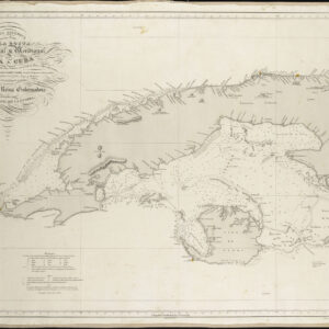
This is Antonio de Herrera y Tordesillas’ rare map of Spanish Americas entitled Descripcion De Las Yndias Del Norte. Herrera was the royal historian to both Phillip II and Phillip III of Spain. He created the map as part of a historical work on Spain’s early colonies in the Americas and East Asia, entitled Descripcion de las Indias Occidentales, which in turn was published as part of his massive Historia General (Madrid, 1601). In scope, the map covers what today constitutes the Southern United States, Mexico, Central America, and the Caribbean.
Like other seminal maps from this work, Herrera compiled this particular map based on the manuscript charts of Spain’s first official cosmographer and imperial chronicler, Juan López de Velasco, between 1575 and 1580.
A map of secrets
The early Spanish mapping of the Americas was integral to Spain’s efforts to control and manage its rapidly growing colonial empire during the 16th century. Following the voyages of Christopher Columbus, Spain rapidly expanded its territories in the New World, acquiring immense land and resources. The Spanish Crown placed great importance on cartography to assert dominion over these territories and facilitate their administration. This task fell primarily to the Casa de la Contratación (House of Trade) in Seville, responsible for producing maps and navigation charts and collecting geographic information from explorers and colonial officials. Cartographers like Juan López de Velasco, who served as the chief cosmographer, played a crucial role in compiling this information and creating accurate depictions of the Americas.
At first glance, Herrera’s map may appear simplistic in style and content. The Caribbean, well-known to the Spaniards at this stage, is strangely void of details, providing only a thin, almost sketch-like outline of the major islands (e.g. Cuba, Hispaniola, San Juan, and Jamaica). The austere lack of detail is repeated in the American interior, virtually void of elaboration. This lack of topographic and toponymic detail was deliberate and sprang from Spain’s well-established policy of secrecy regarding questions of navigation or New World geography.
One of the defining characteristics of Spain’s cartographic policy during this period was its strict policy of secrecy regarding maps and geographic data. As Spain established itself as the dominant colonial power in the Americas, controlling maritime routes, trade winds, and the precise locations of its colonies became matters of national security. The Spanish Crown imposed harsh regulations to prevent this sensitive information from falling into the hands of rival European powers, particularly Portugal, France, and England, which were also vying for global influence. Spain considered its maps state secrets, and unauthorized access or reproduction of these documents was punishable by severe penalties, including death.
This policy of secrecy manifested itself cartographically in several ways. First, access to official maps was restricted to a small group of royal officials, navigators, and high-ranking colonial administrators. Publicly available maps often contained deliberate inaccuracies or omissions, particularly in areas like the Caribbean, where foreign powers might attempt to encroach on Spanish territories. Additionally, maps produced within Spain’s colonial system, such as the Padrón Real, a master map that was constantly updated, were kept under lock and key at the Casa de la Contratación. The Padrón Real was considered the most accurate representation of the known world at the time, and only select navigators were granted access to it before embarking on voyages to the New World.
The Spanish policy of cartographic secrecy delayed the diffusion of accurate geographic knowledge about the Americas to the broader European public. Spain sought to safeguard its economic interests and political supremacy by withholding precise details about colonial territories. Figures like Juan López de Velasco played an instrumental role in shaping and enforcing this policy. Through his work as a cosmographer, Velasco helped systematize the collection of geographic data, producing maps vital to the Spanish Empire’s internal functioning but inaccessible to foreign competitors. This strategy allowed Spain to maintain a significant geopolitical advantage in the early stages of European exploration and colonization of the Americas.
Place names on the map make it clear which areas interest the Spanish Crown. In addition to several Caribbean islands, the Yucatan and Florida peninsulas and the region of Venezuela in South America are labeled. Four city icons identify the principal seats of Spanish administration in the region: Guatimala, Nueve España, Nueva Galizia, and Española. Cutting through the entire composition, we find the Tropic of Cancer.
Census
The current map was one of 14 maps originally published in Antonio de Herrera y Tordesillas’ Descripcion de las Indias Occidentales, a part of his Historia General (Madrid 1601/1622). Examples of Herrera’s book are held by several prominent institutional libraries – particularly throughout Spain (OCLC 11420884). The British Library holds an example of the 1601 edition of the map as a loose sheet (OCLC 500608919). depicting the Americas in Herrera’s seminal work. Other maps from the volume include Descripcion de las Yndias Ocidentales, the earliest printed Spanish map to represent the complete continents of North and South America, and Descripcion de las Indias del Poniente, the First Spanish Map of Southeast Asia (including China, the Philippines, and the Spice Islands).
In 1622, Dutch publisher Michael Colijn of Amsterdam issued a pirated copy of this and the other maps of the volume. The British Library (OCLC 751453922) and Yale University (OCLC 1050159401) hold an example of the current map in its pirated form. Even though the Colijn edition is pirated, without the colophon of the publication, it can be hard to tell the 1601 and 1622 maps apart.
The map also exists in a 1726 reprinted edition. However, this later state is easily identifiable from its use of the toponym Florida in two different locations. While the 1726 state is more than a century later than the original publication, this edition was unknown to Burden at the time of printing of Volume I of his Mapping of North America. Consequently, Burden notes the map for the first time in his Addenda and Corrigenda to Volume II of his magus opus.
Cartographer(s):
Antonio de Herrera y Tordesillas (1549–1626) was a prominent Spanish historian and chronicler best known for his comprehensive works on the history of Spain’s overseas empire. Born in Cuéllar, Spain, Herrera studied humanities and entered royal service, eventually becoming the official historian to King Philip II and later to King Philip III. In this capacity, he had access to a wealth of official documents and records, allowing him to compile detailed histories of Spain’s global conquests. His most famous work, Historia general de los hechos de los Castellanos en las Islas y Tierra Firme del Mar Océano, is a monumental account of Spanish exploration and colonization in the Americas, stretching from the time of Columbus to the late 16th century.
Herrera was also responsible for producing important maps, such as his 1601 map of Southeast Asia, Descripcion De Las Indias Del Poniente, which revitalized Spain’s territorial claims in Asia. His works are considered critical sources for understanding the Spanish Empire, as they cover the Americas, the Philippines, and other parts of Asia. While criticized for favoring Spain, Herrera’s histories remain invaluable for their detail and scope. His works were widely read and translated during his lifetime, cementing his legacy as one of Spain’s foremost chroniclers of empire.
Michiel ColijnMichiel Colijn (1584 – 1637) was an Amsterdam-based printer and publisher trained under prominent bookseller Cornelius Claesz. After Claesz’s death, Colijn acquired much of his publishing infrastructure and opened his own successful business.
The Dutch Pirate Edition
Michael Colijn’s 1622 Amsterdam edition of Antonio de Herrera y Tordesillas’ Descripcion de las Indias Occidentales is generally considered a pirated edition. The book was initially part of Herrera’s historical work, Historia general de los hechos de los castellanos en las islas y tierra firme del mar océano”(a.k.a. Historia general), first published between 1601 and 1615 in Spain. The book was considered highly valuable because of its detailed descriptions and maps of Spanish America, making it a sought-after source of geographical knowledge about the New World.
In 1622, Michael Colijn, a Dutch printer and bookseller, republished the work in Amsterdam without proper authorization from Spanish authorities or the original rights holders. During this time, Spain was highly protective of its geographic knowledge due to ongoing conflicts with rival European powers. The Dutch, in particular, were engaged in the Eighty Years’ War (1568–1648) against Spanish rule of the Netherlands and sought to weaken Spain’s control over the Dutch and Flemish by weakening Spain’s control over her overseas empire. In reproducing and distributing Herrera’s work, Colijn violated Spanish copyright protections and state secrecy policies concerning geographical information. This piracy was motivated by the Dutch desire to access valuable knowledge about Spanish colonies in the Americas.
The Amsterdam edition of Descripcion de las Indias Occidentales was not a legal re-publication but rather an unauthorized attempt to profit from and exploit Spanish intellectual property during a period of intense rivalry.
Condition Description
Very good.
References