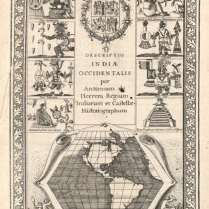
Michiel Colijn (1584 – 1637) was an Amsterdam-based printer and publisher trained under prominent bookseller Cornelius Claesz. After Claesz’s death, Colijn acquired much of his publishing infrastructure and opened his own successful business.
The Dutch Pirate Edition
Michael Colijn’s 1622 Amsterdam edition of Antonio de Herrera y Tordesillas’ Descripcion de las Indias Occidentales is generally considered a pirated edition. The book was initially part of Herrera’s historical work, Historia general de los hechos de los castellanos en las islas y tierra firme del mar océano”(a.k.a. Historia general), first published between 1601 and 1615 in Spain. The book was considered highly valuable because of its detailed descriptions and maps of Spanish America, making it a sought-after source of geographical knowledge about the New World.
In 1622, Michael Colijn, a Dutch printer and bookseller, republished the work in Amsterdam without proper authorization from Spanish authorities or the original rights holders. During this time, Spain was highly protective of its geographic knowledge due to ongoing conflicts with rival European powers. The Dutch, in particular, were engaged in the Eighty Years’ War (1568–1648) against Spanish rule of the Netherlands and sought to weaken Spain’s control over the Dutch and Flemish by weakening Spain’s control over her overseas empire. In reproducing and distributing Herrera’s work, Colijn violated Spanish copyright protections and state secrecy policies concerning geographical information. This piracy was motivated by the Dutch desire to access valuable knowledge about Spanish colonies in the Americas.
The Amsterdam edition of Descripcion de las Indias Occidentales was not a legal re-publication but rather an unauthorized attempt to profit from and exploit Spanish intellectual property during a period of intense rivalry.
-
- Add to cart
- Americas
Descripcion De Las Yndias Del Norte.
- $2,800
- A rare early edition of Antonio de Herrera’s secret map of New Spain.
-
- Add to cart
- Americas, California
Descriptio Indiae Occidentalis per Antonium de Herrera.
- $3,600
- The first map to show California as an island!