A rare and stunning 15th-century rendition of Greater Egypt, in full color and heightened in gold.
[Libya and Egypt] Tabula Tertia Di Libya.
Out of stock
Description
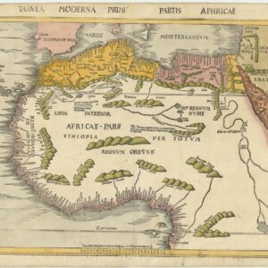
This is Francesco Berlinghieri’s Tabula Tertia di Libya, a rare and early map of Northeast Africa in stunning full color. It is the third of four Africa maps issued in the extraordinary ‘Septe Giornate della Geographia’ published in Florence in 1482. This remarkable proto-atlas was produced when the geographic worldview was still squarely Ptolemaic, and printed maps were an entirely new concept. Even though Berlinghieri follows Ptolemaic tradition – arranging the 31 unsigned maps of his work into a world map, thirteen European maps, four Africa maps, and thirteen Asia maps – many things about the Septe Giornate set it apart from its few contemporary peers.
The subject matter of this map is the eastern third of North Africa, corresponding more or less to modern-day Egypt and most of modern-day Libya. In scope, the map stretches from the Gulf of Sidra in the west to the Red Sea and Sinai in the east. The map aligns with two other Libya plates maps from Berlinghieri’s atlas, which depict the remaining stretch from Tunisia to the Atlantic. Dividing North Africa into these three spheres was anchored in Ptolemaic tradition, and we see roughly the same division in both the Rome (1478) and Ulm (1482) editions of the Geographia.
Berlinghieri drew on a range of unknown sources that he combined with Ptolemy. This means that the place names on his maps can be challenging to identify in many cases. The third Libya plate is different in that we have such a strong understanding of the Classical geography of Egypt. Among the recognizable toponyms, we note the ancient Roman port of Berenice, located on the Red Sea (Arabico Golpho), about 825 km south of Suez and 260 km east of Aswan (lower right corner of the map). Other well-known place names are some ancient cities found along the Nile. Here too, Berlinghieri drew very directly from the Alexandria-based geographer so that Cairo is noted as Babylon and Aswan as Elephanta Isola.
Census
Until recently, most scholars agreed that much, if not all, of the Septe giornate had been completed by 1479 (Skelton 1966; Campbell 1987). This included the maps, which were thought to have been printed in a single large batch and subsequently bound. A significant number of extra sheets were left over from the original printing. After Berlinghieri died in 1501, these were purchased and bound into a new edition with a new title page issued around 1503-1504. The majority of known intact copies of the Septe Giornate appear to be from this later edition, but for a long time, this was considered of little consequence when dealing with the loose map sheets due to the single batch printing. In 2023, a very comprehensive study was published by Peerlings and Laurentius. They identified subtle variations in most of Berlingheiri’s maps, thus demonstrating that amendments were indeed made to the plates and that states of each map exist.
This example of Tabula Tertia di Libya is the 2nd state of two. It can be identified as such by the toponyms NAVSTATHMO and ARCHILLA, located along the Mediterranean coastline, just left of the middle fold, and to the right of the island APHRODITE. In the original first state, these place names are spelled exactly that way. In the second state, the plate was amended so that NAVSTATHMO becomes NAVASTATHINO, whereas ARCHILLA is overprinted and thus no longer legible (Peerlings & Laurentius 2023: 181).
Berlinghieri’s Septe Giornate is listed in the OCLC in several locations, including the Universities of Oxford, Manchester, and Yale, the New York Public Library, the LIBRIS library in Stockholm, and the Morgan Library and Museum, also in New York (no. 644313849). However, the OCLC has only a single listing for the TABULA TERTIA DI LIBYA (no. 164796838), but the Bayerische Staatsbibliothek in Munich holds it.
Context is Everything
Francesco di Niccolo Berlinghieri’s ‘Geographia. In Questo Volume Si Congengono Septe Giornate Della Geographia’ (Seven Days of Geography) was completed around 1479 and printed in Florence in 1482. It is generally regarded as the third printed atlas of the world (following the 1477 Bologna edition and the 1478 Rome edition). It is the first book of maps to be written entirely in Italian, and where the Bologna and Rome editions were attempts to enhance an original translation with visuals, the ‘Septe Giornate’ had an altogether different agenda. Berlinghieri had many passions, but two of his greatest were Classical Greek learning and poetry. In this unique work, Berlinghieri combines the two to approach the subject of geography in an entirely new way. It is, in essence, a paraphrase of Ptolemy’s original text written in Italian verse.
Like all the maps from the Septe Giornate, this one was compiled and engraved by the German printer and engraver Niccolò Tedesco (a.k.a. Nicolaus Laurentii). His skill as an engraver loaded the maps of the Septe Giornate with vibrant detail, bringing a new and strange world to life. Tedesco added many attributes of his own volition and even created four entirely new or ‘modern’ compositions for Berlinghieri (i.e., Hispania Novella, Gallia Novella, Novella Italia, and Palestina Moderna). The discovery of the Americas would soon mean that adding maps to atlases became an ordinary and necessary trend. Still, Berlinghieri and Tedesco first came up with that brilliant idea.
A different trajectory of cartography
Despite having similar spatial division as other early Ptolemies, Berlinghieri’s maps are still considered a distinct cartographic tradition. This is partly due to the aesthetic ambition and ornate carving of the printing plates, but it is also about technical aspects, such as the projections used.
Berlinghieri intentionally used an archaic homeotheric or equidistant cylindrical projection, attributed to Ptolemy’s predecessor, Marinus of Tyre (c.100 CE). By the time the first Ptolemaic Geographies were going into print, however, most mapmakers had shifted away to the new trapezoidal projection attributed to the German cartographer Donnus Nicolaus (c.1420-1490). Cartographic scholar Peter Meurer has pointed out that all known Ptolemaic Geographies from the 15th century were built directly on Donnus Nicolaus’s manuscripts, but Nicolaus himself used different projections over time (Meurer 2007). While the new trapezoidal projection, known as the “Donis-projection,” was used in the Rome Ptolemy and the influential maps of Henricus Martellus, the Ulm edition returns to an equidistant cylindrical projection in order to present the new and updated understanding of Scandinavia based on the work of Danish cartographer Claudius Clavus.
Cartographer(s):
Francesco di Niccolo Berlinghieri (1440–1501) was a 15th-century Italian scholar, humanist, and a keen student of Classical Greek learning. He was one of the first Italians to print a text based on Ptolemy’s Geographia, which he supplemented with his other great passion: poetry.
Niccolò TedescoNiccolò Tedesco (a.k.a. Nicolaus Laurentii; Niccolò di Lorenzo) was a German printer who lived in Florence during the late 15th century. He most likely learned the basics of printing in his native Wroclaw. Tedesco was among the first Italian printers to use copper plate engravings, and he was behind a number of important works from the Italian Renaissance.
Having moved from what is today Poland to Florence, Tedesco first worked in a nunnery of the Dominican Order, where the sisters served as compositors and printers. Among Tedesco’s most famous works, we find Cristoforo Landino’s commentary to Dante Alighieri’s Divine Comedy (first printed in 1472) and the Septe Giornate della Geographia di Francesco Berlinghieri, which was among the first printed atlases based on Ptolemy.
Condition Description
Heightened in gold.
References
Campbell, Tony (1987). The Earliest Printed Maps (1472-1500), British Library: London.
Helas, Philine. (2002). The "Flying Map". Le 'Septe Giornate della Geographia,' by Francesco Berlinghieri \ dedicated to Federico da Montefeltro and Lorenzo de Medici, and depictions of the world in 15th-century Florence (Cartography). Mitteilungen des Kunsthistorischen Institutes in Florenz 46: 271-320
Peerlings, R.H.J. & F. Laurentius (2023). Berlinghieri’s Geography Unveiled. Freely available at www.berlinghieri.eu
Skelton, R.A. (1966). A bibliographical note prefixed to the facsimile of Berlinghieri’s Geographia, Theatrum Orbis Terrarum: Amsterdam.
Meurer, Peter H. (2007). 42 - Cartography in the German Lands, 1450–1650. In The History of Cartography, Volume 3, Part 2. David Woodward (ed.). Chicago: University of Chicago Press. pp. 1182–1183.
![[South Africa] Photograph panorama of Cape Town, c. 1870](https://neatlinemaps.com/wp-content/uploads/2022/09/Screen-Shot-2022-12-18-at-11.22.15-AM-300x300.png)
![[3-Sheet Biodiversity Map of Madagascar] Carte Internationale du Tapis Végétal et des Conditions Écologiques.](https://neatlinemaps.com/wp-content/uploads/2024/05/NL-01035-middle_thumbnail-300x300.jpg)