Briet’s illuminating map of the Holy Land.
Palestinae delineatio ad geographiae canones revocata.
Out of stock
Description
The Biblical story, told through the instruments of modern mapmaking.
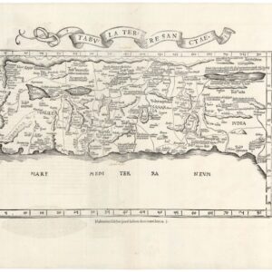
Philippe Briet’s 1641 map, Palestinae delineatio ad geographiae canones revocata, is a rare and intricate depiction of the Holy Land, carefully crafted to align with the latest cartographic conventions. The primary map in the lower register portrays ancient Palestine, spanning both sides of the Jordan River and oriented with the east at the top. This orientation creates a visual layout where the Mediterranean Sea (Mare Magnum) lies along the bottom. The map shows the Holy Land segmented according to the twelve tribes of Israel, reaching from Sidon in the north to Rhinocolura in the south (modern-day El-Arish in Egypt).
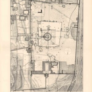
Above the main map are three smaller inset maps, each offering a unique historical perspective. On the top left, we find Syriae veteris descriptio, which depicts ancient Syria based on classical sources. This showcases the broader Eastern Mediterranean and Near East. The central panel consists of a detailed plan of ancient Jerusalem (Hierusalem), explicitly drawn to reflect the presumed configuration in Roman times. The upper right inset, titled Exodus Israelis, traces the Biblical flight of the Israelites from Ramses in Egypt, across the Red Sea, through the Sinai Peninsula, until finally reaching the Promised Land. This map is based on the narrative presented in the Old Testament.
Briet’s subdivision of the Holy Land into tribal territories on the main map was an innovative feature that underscored just how historically and spiritually significant the actual physical land was for Jesuit scholars. Briet created a visual narrative intended to inform education and inspire devotion by intertwining classical geography with ecclesiastical history.
Ultimately, Palestinae delineatio ad geographiae canones revocata stands out not only for its cutting-edge rendering of an ancient geography but also for being the product of a completely new paradigm in cartographic publishing.
Census
This map was part of Briet’s more extensive work, Parallela Geographiae Veteris et Novae, a three-volume historical atlas published between 1641 and 1649 that juxtaposed ancient and contemporary geographic knowledge.
Notably, Briet’s maps were engraved by Henri Le Roy. This specific version bears the imprint of the publisher Pierre Mariette, implying that it is the second state of this map (Michel van Lochom published the rarer first state). From 1650 onwards, the map was sometimes included in the atlases of Nicholas Sanson, who shared a close working relationship with Pierre Mariette.
The OCLC lists several institutional copies, many of which have been recorded under distinct identifiers (e.g., 494957632, 868853167, 494949941, 801694085, 837646542).
Context is Everything
When this map was published in 1641, Europe was in the throes of an intense intellectual and religious curiosity in the Holy Land, primarily driven by the impact of Jesuit scholarship and education. Being a central player in this new paradigm, Briet wanted to use the light of geographical accuracy to illuminate the history of his religion. In many ways, his work reflects the intellectual climate of 17th-century France, which sought to merge historical, religious, and geographic scholarship to bring the ancient narratives to life for contemporary audiences.
Cartographer(s):
Henri Le Roy was a French engraver active in the early 17th century. He specialized in architectural and ornamental etchings. His exact birth and death dates are not documented, but he is believed to have been born around 1579 and was active until at least 1651. Le Roy created intricate designs highlighting the Renaissance and Baroque styles that were prevalent during his lifetime. His works include decorative friezes and architectural motifs, which were in demand for their aesthetic appeal and craftsmanship. One of his known pieces, Frieze with Birds, is housed in the Metropolitan Museum of Art and demonstrates his skill with ornamental themes—depicting birds in a stylized, elongated frieze that illustrates the popular motifs of his period.
Le Roy’s engravings were notable for their clarity and precision, and he was often commissioned to decorate books and architectural plans. His name frequently appeared on plates as “Henri Le Roy excu,” indicating that he was both an artist and publisher, a common practice among engravers of that period. His works were collected and admired throughout France and beyond, contributing to his reputation as a skilled and versatile artist of engravings and etchings in decorative arts collections worldwide.
Philippe BrietPhilippe Briet (1601–1668) was a French Jesuit priest, historian, and cartographer based in Abbeville, France. Known for his meticulous historical and Biblical cartography work, Briet created numerous maps that integrated contemporary and classical geographic knowledge. His most notable publication, Parallela Geographica, released in 1649, featured a collection of maps comparing ancient and modern European geography, focusing on regions such as Sarmatia and encompassing parts of Eastern Europe, including Ukraine, Poland, and Lithuania. This ambitious atlas intended to juxtapose old and new geographies, reflecting Briet’s insistence that history could and should traced cartographically.
Briet continued to expand his work with other cartographic projects, including the Theatrum Geographiae Veteris, an atlas of Europe’s ancient regions, and Theatre Geographique de l’Europe in 1653, a detailed volume that mapped European countries and their provinces. Although he initially aimed to cover all continents, only his work on Europe was published, as his manuscript on Asia never reached publication. He collaborated with notable Parisian publishers like Pierre Mariette, contributing to the era’s development of high-quality geographic atlases and engravings.
Pierre MariettePierre Mariette I (1569–1657) was an influential French publisher and engraver recognized for developing French cartography and publishing during the early 17th century. Initially, Mariette focused on publishing art prints but pivoted to cartography after purchasing map plates from Melchior Tavernier in 1644. He partnered with Nicolas Sanson, a foundational figure in French cartography, to produce detailed folio maps and atlases. In this collaboration, Sanson provided geographic expertise and map designs, while Mariette managed engraving, printing, and distribution. Their maps often included both their imprints, reflecting their partnership’s close, interdependent nature.
Mariette’s legacy extended beyond his lifetime, though disputes over rights to the plates emerged between Sanson and Mariette’s heirs after Mariette’s death. A legal settlement in 1674 allocated most plates to Sanson’s family, leading to a mixture of attributions in later editions of the maps. Pierre Mariette’s contributions laid the groundwork for the Mariette family, who continued to impact French publishing and mapmaking well into the 18th century, establishing the Mariette name as synonymous with high-quality cartographic and artistic publishing in France.
Condition Description
Even mat toning in margins. Original outline color.
References
![[Old Damascus]](https://neatlinemaps.com/wp-content/uploads/2019/09/NL-00657-scaled-300x300.jpg)
![[Old Damascus]](https://neatlinemaps.com/wp-content/uploads/2019/09/NL-00657-scaled.jpg)