John Speed’s Decorative Map of Hungary and Slovakia.
The Mape of Hungari.
$1,900
1 in stock
Description
First edition.
This fine and detailed map of Hungary and parts of modern Slovakia was created as part of John Speed’s Prospect of the Most Famous Parts of the World, an atlas first published in 1631 to accompany his earlier Theatre of Great Britain. The map was jointly published by George Humble and is among the most visually striking representations of Hungary from the 17th century.
The map is framed by an ornate border, featuring two sets of four costumed figures on either side, depicting various social classes in Hungary at the time. These include a senator, a gentleman, a citizen, and a countryman, along with their female counterparts, each shown in traditional regional attire, reflecting the sumptuary laws and social hierarchy of the period. The Hungarian coat-of-arms is prominently displayed at the top center of the map.
At the top of the composition, four city views provide a glimpse into important urban centers of the Hungarian Kingdom:
- Presburch (Bratislava)
- Ofen (Buda)
- Comorra (Komárno)
- Raab (Győr)
The engraving is executed in Speed’s characteristically clean style, balancing geographical accuracy with artistic embellishments. Many of the maps in Speed’s Prospect were adapted from Dutch cartographers, incorporating the carte-à-figure style, which combined decorative elements with functional cartographic detail.
On the reverse side, an English text description offers a 17th-century perspective on Hungary, covering its history, geography, and culture as understood by contemporary English audiences. Speed’s Prospect was the first world atlas published by an Englishman, cementing his legacy as one of the greatest English cartographers of his era.
Cartographer(s):
John Speed (1552-1629) was a prominent English mapmaker and historian operating in the late 16th and early 17th centuries. Born in Farndon, Cheshire, Speed’s interest in maps and geography led him to establish himself as a successful mapmaker and publisher in London. He gained widespread recognition for his detailed and beautifully illustrated maps of various regions, earning him the sobriquet “the leading London cartographer” of the Baroque period.
One of Speed’s most notable works is The Theatre of the Empire of Great Britaine, published in 1611. This ambitious atlas consisted of detailed maps of counties and cities across England, Wales, Scotland, and Ireland, accompanied by historical descriptions and genealogical tables. The atlas was not only a cartographic achievement but also a significant historical record of the British Isles during that era. Speed’s maps were praised for their accuracy and artistic flair, often featuring decorative elements and engravings of notable landmarks and figures. When it came to Britain’s colonial aspirations, Speed was instrumental in visualizing the empire cartographically.
Both during his life and after it, John Speed’s maps enjoyed widespread popularity and were sought after by nobility and scholars alike. Speed reached the ripe age of 77, and his maps were re-published for more than a century after his death. His legacy as a key figure in the development of English cartography endures to this day.
Condition Description
Margins trimmed close, repaired closed tear near lower corner verso, centerfold reinforced verso. Contemporary annotations in margins on verso.
References
Related products
-
-
Add to cart
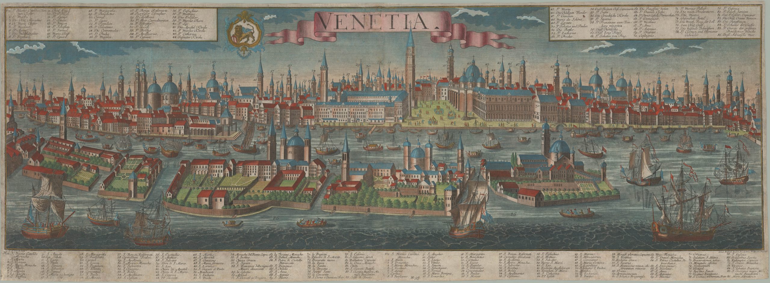
- Europe, Italy, Bird's-eye-views
Venetia.
- $4,800
-
-
-