Rare Abstract of Title for San Francisco’s Reis Tract, with an early and uncertified cadastral map.
[Visitacion Valley SF] Abstract of Title and List of Incumbrances on Reis Tract part Visitacion Rancho.
$650
1 in stock
Description
This is an original 1904 Abstract of Title and List of Incumbrances for Reis Tract in San Francisco’s Visitacion Valley. An ‘abstract of title’ is essentially a collation of legal documents detailing the history of a piece of land or property. In addition to delineating ownership, it catalogs all legal activities associated with the property (e.g. deeds, mortgages, liens, litigations, tax sales, or title transfers). This was a common practice for real estate until the 1940s, after which title insurance made it redundant.
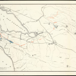
The present Abstract of Title is for the so-called Reis Tract, which essentially consists of Visitacion Valley north of Leland Avenue. As is the norm with such publications, it lists all the properties included in the tract and any historical or outstanding encumbrances. The pamphlet was made in preparation for the original sale of this land by the heirs of California pioneer Julius C. Reis, who it is also named after. Shortly after its publication, the entire area was purchased for development (see context section below).
The pamphlet includes a folding Map of Reis Tract compiled by Ferdinand Reis to help visualize the land. This early cadastral map covers all the blocks between Visitacion Street (now Leland Ave.), San Bruno Road (now San Bruno Ave.), Goettingen Street, and Mansell Street. Drawn at a scale of one inch to 100 feet, it identifies each street within the neighborhood by name and delineates and numbers each parcel or building on the plan.
Several informative annotations are printed on the map. Below the map and outside the frame, large letters read:
FILED IN OFFICE OF COUNTY RECORDER, IN THE CITY AND COUNTY OF SAN FRANCISCO MAY 19th, 1904.
Immediately below the title of the map, a note expands on its purpose:
“Showing lands granted to the City and County of San Francisco for the opening of streets. –
Also showing block subdivisions and block and lot numbers.
NOTE: The lands granted include all lands shown as streets and avenues within the bounds of the tract.”
And finally, in the upper right corner of the map, we are informed about the mapmaker behind it:
“The Map showing location of lands granted through the REIS TRACT by Ferdinand Reis, to the City and County of San Francisco for the opening of several Streets and avenues shown thereon is approved this day of May 1904, by Resolution No.”
The was prepared to be certified by the Commissioners Board of Public Works of the City of San Francisco and attested by the Secretary of said Board of Public Works. However, neither signature appears to have been added. Since the large inscription along the bottom informs us when it was submitted to the County Recorder, we can surmise that the present example was made before its formal approval by the city.
Origins of the Reis Tract
Census
The pamphlet is extremely rare. We have found no institutional examples in the OCLC or any major institutional libraries in the U.S. Nor have we been able to locate any historical sales or parallel examples on the market. It may well constitute the sole surviving copy of this historic document.
Cartographer(s):
Ferdinand Reis (1824 – 1905) was a California pioneer and presumably a relation to the more famous viticulturist Julius C. Reis of Sonoma County. He appears to have been a skilled draughtsman, but to our knowledge, he is not known from other cartographic documents from that era.
Condition Description
Scattered wear.
References
![PORT OF SAN FRANCISCO. WHERE THE FAR EAST BEGINS [Japanese language version]](https://neatlinemaps.com/wp-content/uploads/2021/01/NL-00879_Thumbnail-300x300.jpg)
![PORT OF SAN FRANCISCO. WHERE THE FAR EAST BEGINS [Japanese language version]](https://neatlinemaps.com/wp-content/uploads/2021/01/NL-00879_Thumbnail.jpg)