Stylized Hebrew Version!
נמל סן פרנסיסקו איפה מתחיל המזרח הרחוק [Port of San Francisco Where the Far East Begins].
$1,600
1 in stock
Description
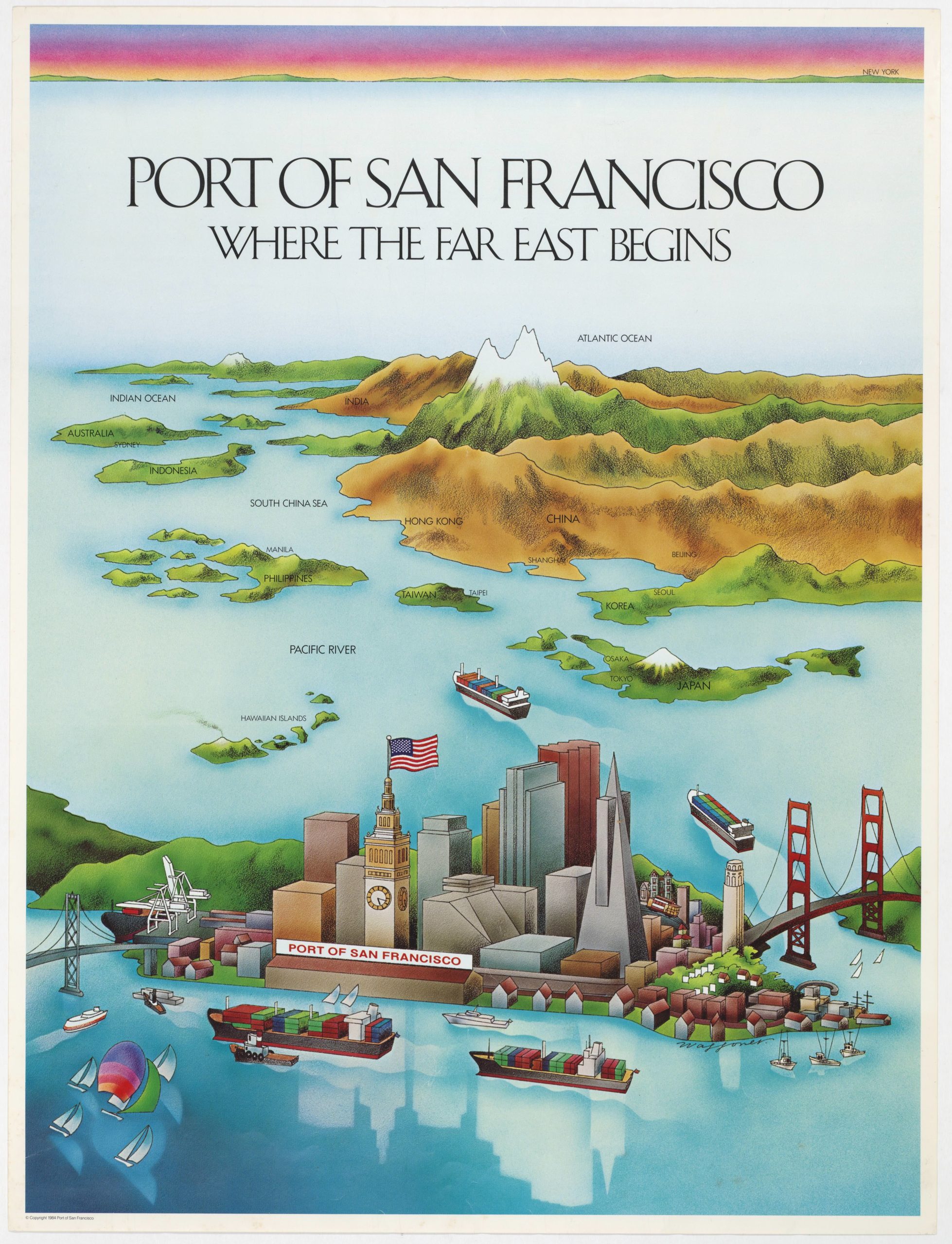
This striking promotional bird’s-eye-view of the Port of San Francisco, titled in stylized Hebrew script, is a brilliant example of persuasive cartography: a deliberate visual distortion of geography designed to highlight San Francisco’s role as America’s gateway to East Asia. The artist radically compresses the Pacific Ocean so that Japan appears only a few ship-lengths beyond the Golden Gate, with Korea, Taiwan, the Philippines, and the broader South China Sea seemingly within immediate reach. In this cleverly manipulated world, the maritime markets of East and Southeast Asia, Indonesia, Australia, and even the northern Indian Ocean fall naturally within San Francisco’s commercial orbit.
The composition is a wonderful example of promotional exaggeration. The Golden Gate Bridge, Bay Bridge, and an active harbor crowded with container ships direct the viewer’s eye outward toward Asia, while San Francisco itself is rendered with affectionate stylization. Major landmarks like Coit Tower, the Transamerica Pyramid, Victorian houses, and a cable car climbing a steep grade, anchor the scene. To reinforce the port’s prominence, the Ferry Building clock tower is drawn at an outsized height, rivaling the city’s skyscrapers (a notable liberty, given its real-world height of just 245 feet).
Vividly printed and visually playful, this map distorts distance to make a clear argument: San Francisco is the natural American launch point to the great maritime economies of the Pacific Rim. As both artwork and advertisement, it captures the port’s aspirational identity in the late 20th century: forward-looking, globally connected, and confident in its place at the edge of the Pacific.
Rarity
This is the first time we have seen a Hebrew version of this map. We have seen English, Japanese, and Korean versions, all of which make sense given the focus of the map. So the impetus behind this version is a mystery to us.
Cartographer(s):
The Port of San Francisco, established in 1863 and governed today by the San Francisco Port Commission, oversees 7.5 miles of waterfront along the city’s eastern shoreline, including piers, maritime terminals, and historic landmarks such as the Ferry Building. Throughout the 20th century, the Port served as a major Pacific gateway for commerce, military logistics, and passenger travel, anchoring San Francisco’s identity as a global maritime city.
WaffonerThe signature “Waffoner” appears on the present poster as the work’s designer or illustrator, but despite extensive searching, no biographical record or professional profile for an artist by this name has been identified. The style—bold gradients, playful perspective, and pseudo-script typography—suggests a commercial illustrator active in the San Francisco Bay Area during the late 1970s or 1980s, likely working for advertising agencies or corporate promotional campaigns. Many such designers operated on contract and left little archival footprint, making attribution difficult.
At present, Waffoner remains an unidentified graphic artist, known only through this rare surviving work.
Condition Description
Excellent.
References