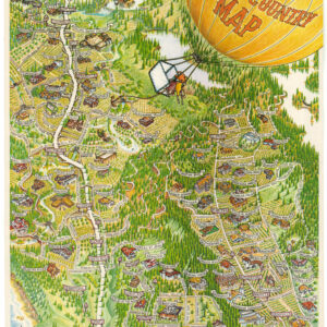
Rare 1891 real estate map of Sausalito, CA.
Map of Sausalito Property at Auction, Waldo Point Tract.
$2,200
1 in stock
Description
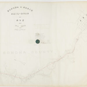
This is a very rare 1891 promotional plat map of the Waldo (or Waldo Point) area of Sausalito, Marin County, in the town’s northernmost part. It was printed by the Schmidt Label and Lithograph Co. for the San Francisco-based real estate magnate William Butterfield.
The map is oriented to the southwest, looking towards Sausalito from Richardson Bay, an arm of San Francisco Bay between Sausalito and Tiburon. Streets, blocks, and lots are labelled, with lot sizes also noted. At the bottom is the North Pacific Coast Railroad, the main thoroughfare through this part of Marin County at the time, with Waldo Station illustrated. The verso includes promotional text on the benefits of living in Sausalito, the terms of sale, and the measures Butterfield takes to facilitate sales, including free transportation to the site from San Francisco.
Context is Everything
In the late 1800s, the shoreline in this area was a rugged stretch of Richardson Bay where the hills met mudflats. The Waldo Point area was largely defined by the expansion of the North Pacific Coast Railroad, which established a right-of-way through this area in the 1870s, creating a vital link between the Sausalito ferry terminal and the timber-rich lands of Marin and Sonoma Counties. This industrial presence brought the first significant infrastructure, including trestles and tracks that carved through the marshy terrain.
The area takes its name from William Waldo (1812 – 1881), a mid-19th-century politician and California pioneer who was famous for organizing relief efforts for struggling immigrant trains heading overland to California. By the late 1800s, “Waldo” became the designated name for the railroad station (seen here) and the surrounding acreage. During this period, the shoreline was dotted with small-scale shipbuilding operations and drying grounds for local fishermen. Increasingly, the waterfront also included “Arks”— flat-bottomed houseboats named after Noah’s Biblical vessel — belonging to affluent San Franciscans and bohemian types. These ships would anchor in the sheltered waters of Richardson Bay during the summer months but were hauled up onto the marshy banks of Waldo Point during the winter to protect them from storms. This seasonal rhythm established Waldo Point as a site where the boundaries between land and water were perpetually blurred, setting the stage for the permanent maritime colony that would define the area in the 20th century.
At the same time, the area was being aggressively subdivided. Sausalito was reimagined not just as a maritime village, but as a prestigious “villa” retreat for San Francisco’s growing professional class. William Butterfield, a premier San Francisco auctioneer whose firm would later become the famous Butterfield & Butterfield, was the perfect showman for this endeavor.
The May 1891 auction conducted by Butterfield was a watershed moment for the Waldo Point area, representing the transition of the land from a rugged railroad outpost into a marketable suburban commodity. Potential buyers were provided with complimentary ferry passage from San Francisco and specialized train transfers via the North Pacific Coast Railroad to the Waldo stop. The lots offered were primarily “hillside sites” and “waterfront frontage.” While the shoreline was already occupied by industrial rail activity, which no doubt interfered with the serenity of the “waterfront” lots, the hills above Waldo Point were sold as the future site of grand residences, pitched on the verso as “Nob Hill No. 2,” in reference to the ultra-posh San Francisco neighborhood.
The 1891 sale was successful in terms of volume, with dozens of lots sold on “easy terms.” However, the vision of a manicured hillside suburb did not immediately materialize. The economic Panic of 1893 followed shortly afterwards, cooling the real estate market and leaving many of these lots undeveloped for years. This delay helped the “Ark” and houseboat culture to take root. Since many of the lots were mere “paper streets” (on maps but not physically built), the shoreline remained accessible to the fishermen, shipbuilders, and bohemians who would eventually form the backbone of the Waldo Point community.
Still, the May 1891 auction effectively fixed the modern property boundaries of the area. Even today, the legal descriptions of many properties in the Waldo Point and Manzanita areas trace their lineage back to the maps drawn up for the May 1891 Butterfield sale.
Census
This map was printed by the Schmidt Label and Lithograph Co. for the real estate promoter W. Butterfield in 1891, likely just weeks before the auction took place. It is very rare, with only one other known example, held by the Bancroft Library at the University of California, Berkeley (OCLC 24391996).
Cartographer(s):
The Schmidt Label & Lithography Company was an American publishing house based in San Francisco and which specialized in the printing of labels (although separate prints also were issued). It was founded in 1873 by a German immigrant, Max Schmidt. Schmidt was one of the first West Coast printers to use the lithographic technique, giving him a distinct advantage over his competitors and cementing his success. By the 1890s, he ran a factory in the city as well as branches in Portland and Seattle. Despite facing severe set backs, including several fires and the complete destruction of his plant in the 1906 earthquake, Schmidt was an extremely resilient and innovative businessman. Within a few years of the 1906 devastation, the Schmidt Company had become one of the largest printing houses on the West Coast.
Condition Description
Repaired upper left corner, else good.
References