Mapping a newly independent Middle East.
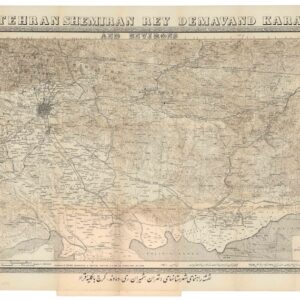
[Illustrated Physical Map of the United Arab Republic The Syrian region, Lebanon, Palestine and Transjordan].
$575
1 in stock
Description
The Illustrated Physical Map of the United Arab Republic The Syrian region, Lebanon, Palestine and Transjordan (مصور طبيعي .. الجمهورية العربية المتحدة الإقليم السوري ولبنان وفلسطين وشرق الأردن) is a large-format, Arabic-language physical and political map of the Levant, encompassing the Syrian region, Lebanon, Palestine, and Transjordan. The map was produced in 1959 by the Syrian cartographer Ibrahim Hilmi al-Ghouri, shortly after Syria became an independent nation.
The map functions as both a physical relief chart and a political delineation of the Levant in the immediate post-1958 era, balancing topographic representation with contemporary political geography. Color shading distinguishes the lush lowlands (greens) from the elevated plateaus, highlands, and deserts (tans and browns). The shading also indicates more subtle variations in elevation across the region. Physical features such as mountain ranges (e.g., the Anti-Lebanon and Lebanon Mountain ranges), river systems (the Orontes and the Jordan River), desert expanses, and coastal plains are also carefully delineated by color coding. Even the bathymetry of the eastern Mediterranean includes depth gradients through shading.
Superimposed on the physical relief are comprehensive cartographic symbols representing a variety of features. These include major cities and towns (shown as distinct dots or circles labeled in Arabic); highways and principal roads depicted by solid or dashed black lines; railways; administrative boundaries and regional divisions; and both maritime and inland routes.
The map’s legend, located at the lower right, explains these symbols and features (in Arabic). Immediately above the legend is a rectangular inset showing a broader view of the United Arab Republic (UAR), here framed to include Egypt and Syria united under a single state (see the context section for more). This inset emphasizes the political unity of Pan-Arabism that defined the period during which the map was produced. Above the map proper, Arabic calligraphy names the map and states the region covered. A second calligraphic text at the bottom of the map provides narrative context and relevant statistics. These include area and population figures for the UAR, and a brief geographical summary of the mapped territories. A notable anomaly in the bottom text reveals a pasted-over number “19” (in reference to 19,000 km²), which must have replaced an earlier figure. This indicates a post-printing correction to reflect the latest data. It is tangible evidence of the extreme flux in the Middle East during the 1950s.
Notably, the map does not depict the State of Israel with international boundary demarcation. Instead, the area historically known as Palestine is shown without a formal political boundary between Israel and neighboring Arab states. This reflects a particular, politicized geopolitical perspective and speaks to both the cartographer’s ideology and the map’s intended audience.
Context is Everything
The present map was produced in 1959, shortly after the establishment of the United Arab Republic (UAR). This was a political union between Egypt and Syria that officially came into being on 1 February 1958. The union represented the apex of pan-Arab nationalism, driven by a shared anti-colonial sentiment and the charismatic leadership of Egyptian President Gamal Abdel Nasser. The UAR was both symbolic and strategic, emerging amid the Cold War and the ongoing Arab–Israeli conflict. Regional elites in Syria, concerned by domestic instability and the influence of Communist factions, saw the alliance with Nasser’s Egypt as a stabilising force. The formal union included a standard government structure, a unified flag, and a legislative framework designed to integrate administrative systems across the two formerly sovereign states.
The UAR was short-lived, ending already in 1961 when Syria seceded following a coup d’état fomented and executed by Syrian military officers under the leadership of Abd al-Karim al-Nahlawi. The coup created the Syrian Arab Republic (1961–1963) and, more importantly, set the stage for the Baʿathist coup of 1963 and eventually Hafez al-Assad’s rise to power in 1970.
This historical backdrop is crucial to understanding the map, as it explains the depiction of Transjordan, Lebanon, and Palestine within a unified geographic space that mirrors the pan-Arab nationalist aspirations and the perception of the Levant as a contiguous cultural and physical region. The blatant absence of international borders around Israel, replaced instead with an undifferentiated Palestine, underscores the contemporary political sensitivities and competing territorial narratives resulting from the Arab–Israeli War of 1948 and its aftermath.
In this manner, our map, like many maps of this period, serves not only a geographical function, but also an ideological one. In the late 1950s, cartographers often reflected national and regional political positions regarding sovereignty, identity, and territorial claims. The choice to foreground the UAR and its allied territories within a singular graphic frame is essentially al-Ghouri articulating a vision of ethnic unity and shared ecology that aligned smoothly with the prevailing pan-Arab disposition.
The UAR’s short lifespan gives this map additional historical significance. It captures a fleeting moment in Middle Eastern political history when Egyptian-Syrian unity reshaped regional cartography and allowed Arab mapmakers to visually assert new political aspirations and realities onto a recently decolonized Middle East.
Cartographer(s):
Ibrahim Hilmi al-Ghouri (1925-2004) was a Syrian geographer and cartographer known primarily for his mid-20th-century contributions to Arabic cartographic literature. His body of work spans both scholarly and educational domains, and he produced several critical Arab atlases, including Atlas of the Modern World (أطلس العالم الحديث), Natural Atlas of Syria (الأطلس الطبيعي لسورية), and the Natural and Human Atlas of the Arab World (الأطلس الطبيعي والبشري للوطن العربي). These works combined conventional cartography with illustrative and textual detail, reflecting both scientific precision and an intention to educate Arabic readers about geography. Other information about his broader biography, such as formal training or institutional posts, is sparse.
Al-Ghouri’s maps are characterized by detailed terrain shading, careful symbol usage, and integration of physical and political information, making them valuable for both academic reference and classroom instruction. His work demonstrates an approach that foregrounds natural landscapes alongside human political structures, situating the human experience within the broader environment.
Condition Description
Good. Original covers.
References

![[Unusual Jerusalem engraving / proof]](https://neatlinemaps.com/wp-content/uploads/2025/06/NL-02380_thumbnail-300x300.jpg)
![[Old Damascus]](https://neatlinemaps.com/wp-content/uploads/2019/09/NL-00657-scaled-300x300.jpg)
![[Old Damascus]](https://neatlinemaps.com/wp-content/uploads/2019/09/NL-00657-scaled.jpg)