Speed’s cartes-à-figures map of the Americas: a milestone in English cartography.
America with those known parts in that unknowne worlde both people and manner of buildings described and inlarged by I.S. Ano 1626.
$4,000
1 in stock
Description
A gorgeous example.
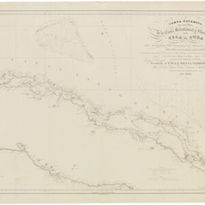
John Speed’s landmark 17th-century map of the Americas offers a unique perspective on the New World. Stretching from the Davis Straits in the north to Tierra del Fuego in the south, it presents the Americas in their entirety. It features an inset in the top-left corner that extends the cartographic canvas to the North Pole. The inset introduces isolated Arctic locations, such as Baffin Bay and Greenland, as well as North Atlantic features, such as Iceland and the mythical Frisland.
A Celebration of Pre-Columbian Cultures
Like many of Speed’s maps, the Americas sheet was designed as a cartes-à-figures, meaning the central map was flanked on both sides by a border of vignette portraits depicting Pre-Columbian inhabitants and their different forms of ‘native dress.’ Cartes-à-figures was a common form used by Speed in his regional maps, but in the Americas, these depictions naturally generated extra interest, as they were among the first popular renditions of the people inhabiting these strange new continents. Speed treats us to ten portraits of indigenous peoples inhabiting the Americas. From the top left to the bottom right, these consist of a Greenlandic (Inuit) male, a Virginian male, the King of the Floridians, a Mexican female, the king of New England, a Peruvian male, a Brazilian male, a Brazilian female, a Mochan male (southern Peru), and a Magellanican (Patagonian).
Along the top of the map is a second frieze of vignettes, this time offering views of the most famous settlements in the New World. The selection of these reveals that this map was conceived very early in America’s colonial history, for the northernmost town depicted is Mexico City. From left to right, the major towns of the Americas are Havana, Santo Domingo, Cartagena, Mexico City (Tenochtitlan), Cusco, Mocha Island (Chile), Rio de Janeiro, and Olinda, the great port of Pernambuco in Brazil.
Unraveling the Island Myth: Speed’s enigmatic depiction of California
One of the defining aspects of Speed’s map is its portrayal of California as an island. This was a fascinating cartographic misconception that persisted throughout the 17th century and well into the 18th. The depiction of California as an island was, in this case, adapted from the configuration on Speed’s double-hemisphere map in the same atlas, which in turn was based on William Grent’s world map from 1625. The earliest example of California being depicted as an island on a printed map is found on the pictorial title page of Michiel Colijn’s expanded edition of Antonio de Herrera y Tordesillas’s Descritio Indiae Occidentalis from 1622.
While the configuration was thus not entirely unknown, Speed’s map of the Americas constituted the first detailed portrayal of this idea in a regional atlas, and the notion clearly captivated and intrigued both mapmakers and their patrons. Soon, the idea was widely adopted by Dutch, French, German, and Italian cartographers, and it was not until Father Kino walked the route and definitively dismissed the idea of California as an island that the notion began to slowly abate in cartography. Father Kino’s map was published in Paris in 1705.
The Unseen Narrative: The English verso text
As one explores the map’s many innovative and seminal features, an additional treasure is hidden on the verso. Here, the English text describes the rich history and geography of the Americas as understood in the 17th century. This textual companion to the map unlocks stories embedded in the imagery and relays some of the tall tales of exploration, trade, and conquest that shaped Americans’ understanding of the 17th century. As such, the verso text provides detailed, time-specific context that complements the cartographic masterpiece on the front.
Concluding Remarks
John Speed’s carte-a-figure map of the Americas, with its groundbreaking depictions of America’s Pre-Columbian inhabitants and California as an island, continues to fascinate map historians, collectors, and enthusiasts alike. It is an extraordinary cartographic representation that offers a compelling glimpse into the New World during the Age of Exploration and Discovery. With its meticulous details, vivid colors, and intricate vignettes celebrating America’s indigenous cultures, this map testifies to the power of visual imagery to convey and stimulate the allure of these vast new continents.
Publication information
This map was originally engraved by Abraham Goos in 1626 and was later featured in Bassett and Chiswell’s posthumous printing of Speed’s renowned ‘Prospect of the Most Famous Parts of the World from 1676.
Cartographer(s):
John Speed (1552-1629) was a prominent English mapmaker and historian operating in the late 16th and early 17th centuries. Born in Farndon, Cheshire, Speed’s interest in maps and geography led him to establish himself as a successful mapmaker and publisher in London. He gained widespread recognition for his detailed and beautifully illustrated maps of various regions, earning him the sobriquet “the leading London cartographer” of the Baroque period.
One of Speed’s most notable works is The Theatre of the Empire of Great Britaine, published in 1611. This ambitious atlas consisted of detailed maps of counties and cities across England, Wales, Scotland, and Ireland, accompanied by historical descriptions and genealogical tables. The atlas was not only a cartographic achievement but also a significant historical record of the British Isles during that era. Speed’s maps were praised for their accuracy and artistic flair, often featuring decorative elements and engravings of notable landmarks and figures. When it came to Britain’s colonial aspirations, Speed was instrumental in visualizing the empire cartographically.
Both during his life and after it, John Speed’s maps enjoyed widespread popularity and were sought after by nobility and scholars alike. Speed reached the ripe age of 77, and his maps were re-published for more than a century after his death. His legacy as a key figure in the development of English cartography endures to this day.
Condition Description
Excellent.
References