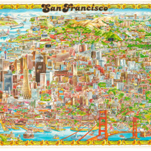
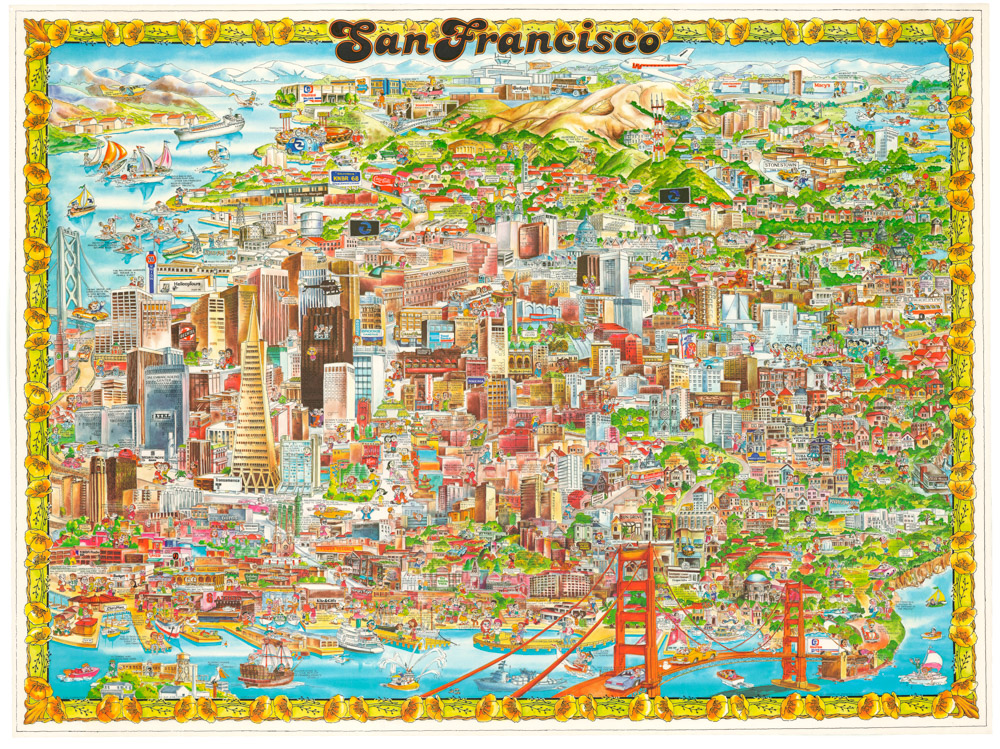
Roaring Twenties Pictorial Map of San Francisco.
Map of San Francisco Showing Principal Streets and Places of Interest.
$3,500
1 in stock
Description
The Greatest Pictorial Map of Jazz Age San Francisco
This is a 1927 Godwin Pictorial Map of San Francisco, one of the largest and most lavishly illustrated cartographic portraits of the city ever produced, depicting San Francisco at the height of the Jazz Age — before the Golden Gate Bridge, before the Bay Bridge, and still within living memory of the great earthquake and fire of 1906. Touted on the map itself as “The City That Knows How” and “The Ideal Convention City,” it presents the city as a place of energy, humor, and civic pride, with hundreds of hand-drawn vignettes capturing everything from the bison in Golden Gate Park to the roller coaster at Playland. It is as much a social document as a cartographic one, and among the most entertaining maps of any American city from the period.
The Map in Detail
The map covers the full San Francisco peninsula from the Golden Gate and Fort Point in the north to the southern neighborhoods, with the Pacific Ocean to the west and San Francisco Bay to the east. Principal streets are shown in yellow, with neighborhoods labeled in bold red — the Richmond District, Sunset District, Mission District, Hayes Valley, Potrero, and Chinatown among them — while the Presidio’s U.S. Military Reservation and Golden Gate Park occupy the western half of the city. Two inset maps accompany the main sheet: a smaller pictorial map of San Francisco’s early historical events in the lower left, and a geographic overview of San Francisco Bay and its vicinity in the lower right.
The illustrations throughout are remarkable in their density and wit: a couple dances an exaggerated Charleston, a cowboy is bucked from his horse, divers leap from the Lurline Pier into the saltwater pools of Ocean Beach, and a tourist photographs the view from Sutro Heights. The shipwrecks of the Lyman Stewart (1922) and Coos Bay (1927) are marked off Land’s End. A blimp hangar appears inside the Presidio gate — a short-lived Coast Artillery experiment using tethered observation balloons for shore battery spotting — and a rag-and-bones man with his horse and wagon makes his rounds through the Richmond District.
Historical Context
San Francisco in 1927 was a city in confident mid-stride. The trauma of the 1906 earthquake and fire — depicted in the historical inset — had been absorbed and transcended; the rebuilt city was booming, cosmopolitan, and self-consciously modern. Yet the landmarks that would come to define San Francisco’s global image were still years away: the Golden Gate Bridge would not open until 1937, nor the Bay Bridge until 1936. The city Godwin mapped was one still served by ferries, still defined by its neighborhoods and streetcar lines, still possessed of amusements — Playland, the Cliff House, the saltwater plunge — that have long since vanished. The map’s tone is deliberately celebratory and promotional, aimed at tourists but equally cherished by locals as a snapshot of a city on the cusp of becoming the San Francisco of legend.
Publication History and Census
This map was drawn by Harrison Godwin and published in San Francisco in 1927. It is one of the most popular American pictorial maps ever produced.
Cartographer(s):
Harrison Godwin (1899 – 1984) was an American cartoonist and map illustrator active in California during the first half of the 20th century.
Schmidt Label & Litho. Co.The Schmidt Label & Lithography Company was an American publishing house based in San Francisco and which specialized in the printing of labels (although separate prints also were issued). It was founded in 1873 by a German immigrant, Max Schmidt. Schmidt was one of the first West Coast printers to use the lithographic technique, giving him a distinct advantage over his competitors and cementing his success. By the 1890s, he ran a factory in the city as well as branches in Portland and Seattle. Despite facing severe set backs, including several fires and the complete destruction of his plant in the 1906 earthquake, Schmidt was an extremely resilient and innovative businessman. Within a few years of the 1906 devastation, the Schmidt Company had become one of the largest printing houses on the West Coast.
Condition Description
Minor wear in the bottom right corner.
References
Rumsey 8102.000. https://richmondsfblog.com/2014/09/10/1927-tourist-map-highlights-neighborhood-landmarks/