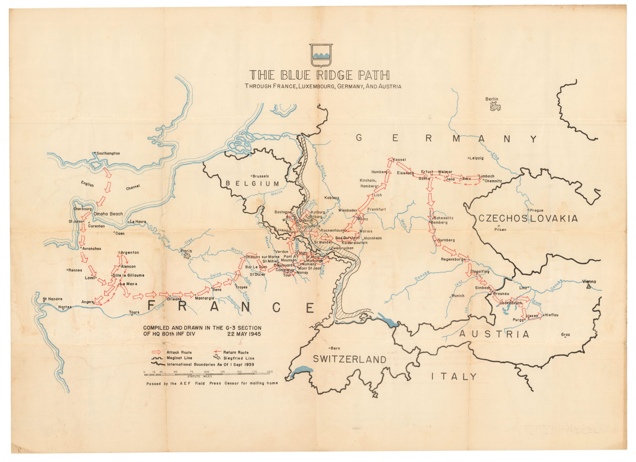
1693 Collins Nautical Chart of the Firth of Forth, with Plan of Edinburgh.
[Edinburgh Firth]
$1,000
1 in stock
Description
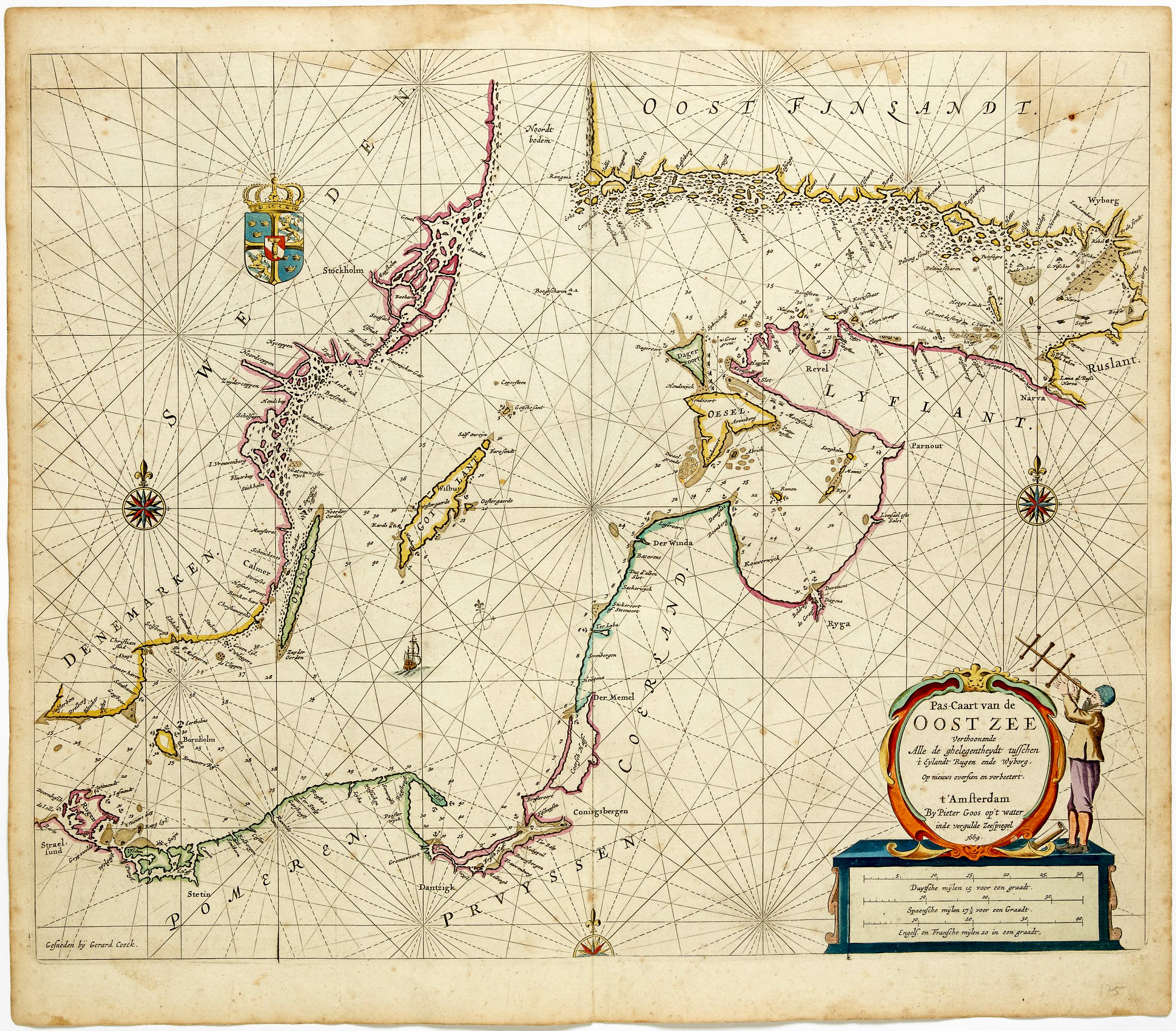
Edinburgh Castle and the Firth of Forth, Scotland’s Principal Estuary.
This chart of the Firth of Forth from Captain Greenville Collins’s Great Britain’s Coasting Pilot of 1693 is among the most layered plates in the entire atlas, combining a rigorously practical hydrographic survey of Scotland’s principal estuary with a schematic plan of Edinburgh, the most heraldically elaborate cartouche in the series, and a dedication that by the time of publication had become an inadvertent monument to the fallen Stuart order. The chart is dedicated to James Drummond, fourth Earl of Perth, Lord Chancellor of Scotland under James VII and II, a prominent Catholic convert and Jacobite who had fled into exile at the Revolution. That dedication, unchanged across subsequent editions, stands as what the survey’s original timing makes it: a quiet fossil of the old regime embedded within the atlas.
The Map in Detail
The chart surveys the Firth of Forth from its mouth between Fifeness and the Bass Rock westward to Edinburgh and Queensferry, taking in both the Fife coast, including Kirkcaldy, Burntisland, Kinghorn, and the Isle of May, and the Lothian shore from Dunbar and the Berwickshire border through Musselburgh, Leith, and the approaches to the capital itself. Edinburgh is depicted with a schematic plan of the old town and its castle, giving the sheet an unusual topographic register amid an otherwise explicitly nautical format. A red line traces what appears to be a recommended fairway or tidal channel up the southern shore of the estuary, a practical navigational aid of the kind Collins employed on only a handful of plates. Depths are densely sounded throughout, with particular attention to the notorious Carr Rocks and the banks off the Burntisland and Kirkcaldy roadsteads. A grid of rhumb lines extends from multiple compass roses, one set near the open sea and another within the estuary. The cartouche in the upper left is among the most heraldically elaborate in the series: the Scottish arms, a lion rampant on a golden field, surmounting a trophy of crossed Scottish and English flags, cannon, and drums, flanked by mermaids and set above a seascape vignette.
Historical Context
James Drummond, fourth Earl of Perth, had been one of the most powerful men in Scotland under James VII and II, serving as Lord Chancellor and converting to Catholicism in 1685 in conspicuous alignment with the King’s religious policies. When the Revolution of 1688 brought William III to the throne, Perth’s position became untenable. He fled Scotland and spent the remainder of his life in Jacobite exile, dying in Saint-Germain-en-Laye in 1716. Collins’s survey had been completed before these events, when Perth was still at the height of his authority, and the dedication was inscribed accordingly. That it was never altered for subsequent editions of the atlas reveals something important about the commercial logic of the Coasting Pilot’s long publishing history: the copper plates were expensive assets, and the Mount firm reprinted them for decades without significant revision. The result is that Perth’s name, and the heraldic apparatus of Scottish royal authority that surrounds it, survived unchanged through all the political transformations that followed, a dedication to a man who had become an outlaw preserved in copper long after the world that produced it had been overthrown.
Publication History and Census
This chart appears as a plate in Great Britain’s Coasting Pilot, first published in London in 1693. The plates were reprinted throughout the eighteenth century by the Mount publishing dynasty, first as Mount & Page and later as Mount & Davidson, and surviving sheets are most commonly encountered as individual disbound leaves.
Cartographer(s):
Captain Greenville Collins (c. 1643–1694) was an English naval officer and pioneering hydrographer whose work laid the foundation for systematic coastal charting in Britain. Serving in the Royal Navy during the late seventeenth century, Collins gained practical experience in navigation and surveying at a time when reliable nautical charts of British waters were scarce. Recognizing the strategic and commercial importance of accurate maritime information, the English crown commissioned him in the early 1680s to conduct a detailed survey of the coasts of England and Wales.
Between roughly 1681 and 1688, Collins directed an extensive hydrographic survey of the English coastline, measuring depths, mapping shoals and sandbanks, and documenting harbors and navigational hazards. His work represented one of the first coordinated national charting efforts in England. The results were compiled into Great Britain’s Coasting Pilot, first published in 1693. The volume combined detailed engraved charts with sailing directions and coastal views, providing mariners with far more reliable guidance than previously available.
Collins’s atlas became the standard reference for navigation around British waters for decades and marked an important step in the professionalization of hydrography in England. His methods and charts influenced later surveying practices and helped improve maritime safety during a period of expanding naval power and overseas trade. Collins died in 1694, only a year after the publication of his landmark work, but his contributions established him as one of the earliest significant hydrographers of the British Isles.
Condition Description
Wear along the centerfold and margins. Image is nice.
References