1631 Merian map of the Western Hemisphere with polar insets
America noviter delineata
Out of stock
Description
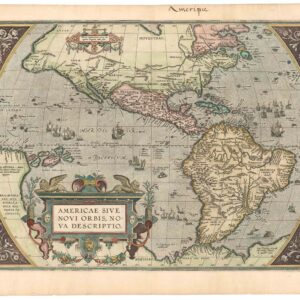
This is the uncommon, larger version of Merian’s map of the Americas, based on the cartography of Jodocus Hondius’s map of 1618.
North America features a large inset of the north polar region including Greenland and Iceland. It is positioned prominently to cover up unknown interior regions of modern-day Canada. A large, bulging Virginia and an odd New England coastline are drawn, and the continent is filled with important place names (including many Indian villages) and geographical features. The western coastline above California extends toward Asia, making the continent too wide. The mythical Seven Cities of Cibola are situated on a lake, which is imagined as the source of the Rio Grande. There is only a hint of the Great Lakes and no Long Island.
For its part, South America is depicted oversized, with Brazil extending far out into the Atlantic. The continent is filled with depictions of cannibals, explorers, animals, and pictorial mountain ranges. A mythical lake, Parime Lacus, is situated on the equator.
A strapwork cartouche with skulls and bones, sea monsters lurking in the oceans, and cannibals preparing a feast, all give this map a stunning macabre style.
Published in Newew Welt und Americanische Historien.
Cartographer(s):
Matthäus Merian (September 1593 – 19 June 1650) was a Swiss-born engraver who worked in Frankfurt for most of his career, where he also ran a publishing house. He was a member of the patrician Basel Merian family.
Early in his life, he had created detailed town plans in his own unique style, for example plans of both Basel and Paris (1615). With Martin Zeiler (1589 – 1661), a German geographer, and later (circa 1640) with his own son, Matthäus Merian produced a collection of topographic maps. The 21-volume set was collectively known as the Topographia Germaniae and included numerous town-plans and views, as well as maps of most countries and a world map. The work was so popular that it was re-issued in many editions. He also took over and completed the later parts and editions of the Grand Voyages and Petits Voyages, originally started by Theodor de Bry in 1590. Merian’s work inspired the Swedish royal cartographer, Erik Dahlberg, to produce his Suecia Antiqua et Hodierna, which became a cornerstone in European mapping.
After his death, his sons Matthäus Jr. and Caspar took over the publishing house. They continued publishing the Topographia Germaniae and the Theatrum Europaeum under the name ‘Merian Erben’ (i.e. Heirs of Merian). Today, the German travel magazine Merian is named after him.
Condition Description
Strong and dark impression. Some professional restoration; backed on Japanese tissue paper.
References
Burden, Philip D. The Mapping of North America: a list of printed maps, 1511-1670. Rickmansworth, Herts.: Raleigh Publications, 1996, 235.