Rare 1873 Sausalito property map with old town spelling.
Map of the Old Saucelito Land and Dry Dock Co.’s Lands Showing the Property for Sale at Auction By Maurice Dore & Co. Auctioneers Tuesday July 22nd 1873
Out of stock
Description
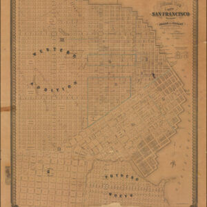
Early advertising map of Sausalito announcing land sales in the area around Main Street, with new streets planned beyond the original shoreline.
The map is oriented with west at the top and identifies lots to be sold at auction by Maurice Dore & Co. in July of 1873. The numbered lots are between Main Street and Story Avenue, which was just north of North Street but is not on modern maps.
“Saucelito” comes from Spanish, meaning “little willow grove.” The alternate spelling of “Sausalito” proved more popular and the town post office officially adopted the latter version in 1887.
The initial land grant of Saucelito was awarded to William Richardson, one of the most important figures in 19th century San Francisco and Marin County history. Richardson built a house at today’s Second and Valley Streets. He eventually fell into debt and sold much of the land comprising Old Saucelito.
In 1868, the Saucelito Land and Ferry Company was established to draw the attention of prospective settlers. The company purchased about 1,200 acres situated on the south side of Richardson’s Bay and divided it into town lots and country seats, laying out a street grid. The company also established a ferry line to and from San Francisco.
The first building erected in the new town was the Saucelito Hotel in 1869. This was soon followed by a two-story hotel and general store near the ferry landing erected by James Greene. A post office was established on December 12, 1870.
Census
OCLC WorldCat (#24330504) shows only two institutional holdings: UC Berkeley Libraries and the California Historical Society.
We are aware of no other examples offered on the private market.
Cartographer(s):
George Henry Goddard (1817-1906) was an accomplished artist and civil engineer who played a pivotal role in California’s early history. Originally from England, he ventured to California during the height of the Gold Rush, initially seeking fortune in the goldfields. His transition to professional surveying soon entailed working for the California government and winning lucrative contracts from railway and mining companies. This work, in turn, led to significant contributions in cartography, including notable publications such as Britton & Rey’s Map Of The State Of California (1857).
In recognition of his groundbreaking work in surveying the Sierra Nevada, one of the range’s highest peaks (13,564 feet) was named ‘Mount Goddard’ after him in 1864. His later move to San Francisco saw the creation of several iconic representations of the city and its surroundings, etching his name into San Francisco’s historical legacy.
Throughout his adult life, Goddard diligently collected historical objects and documents pertaining to California. Stanford was planning on building a museum for his collection when it was destroyed in the fires following the 1906 San Francisco Earthquake. While Goddard himself survived the conflagration, the calamity took such a toll that he died a few months later.
George Holbrook BakerGeorge Holbrook Baker (1827-1906) was a Massachusetts-born artist who learned his trade from the New York engraver George C. Smith. Following his apprenticeship, Baker attended the National Academy of Design before emigrating to California during the height of the Gold Rush. He arrived in San Francisco in late May 1849, and within three months, his first views of the town were being published in New York.
Baker briefly tried his luck prospecting for gold, but like so many other emigrants, he found that it was easier to make a living using the talents and skills with which he arrived. Even today, it is a commonly held notion that the people who became rich from the Gold Rush were the shovel and pan-sellers rather than the prospectors themselves.
In 1852, Baker moved from San Francisco to the new state capital at Sacramento, where he started several businesses and two periodicals while also creating new and sought-after views of northern California. In 1857, Baker drew and published a large birds-eye-view of the young ‘City of the Plain’ (printed as a lithograph by Britton & Rey in San Francisco), which achieved enormous popular success. In 1862, after a devastating flood had ruined him, Baker moved back to San Francisco and started a lithography and publishing firm that specialized in advertising and posters, including architectural and urban vistas, dedicated stock certificates, and regional maps. Despite more than a decade of success, his company was gradually outcompeted during the 1880s, and by around 1890, Baker closed his doors and retired.
Despite his ending in commercial failure, George Baker is acknowledged as one of the most significant artists and lithographers of the Gold Rush era. His work constitutes some of the most important visual documentation of California during the formative decades of its incorporation into the United States.
Condition Description
Inkstamp "Remington Collection" in lower margin, with number 9357 stamped in lower blank portion of map.
References