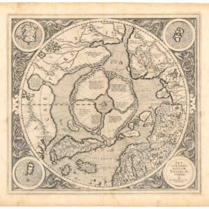
1623 map North Pole heightened in gold and filled with cartographic myths.
SEPTENTRIONALIUM Terrarum descriptio. Per Gerardum Mercatore
Out of stock
Description
This is the first map devoted to the Arctic, hemispherical with a North Polar projection and surrounded by an attractive floral design. Among the numerous cartographic myths depicted on the map are: the Rupes Negra, the island of Frisland, the Straight of Anian, Lake Conibas, and more.
In the corners are four roundels, one of this contains the title, the other three contain maps of the Faeroe Isles, the Shetland Isles and Frisland. Recent attempts at finding the North West and North East Passages are depicted. The results of Frobisher’s and Davis attempts are recorded.
California is labeled (Califormia) and is described as Spanish territory.
With ‘t Behouden huys’ engraved near Nova Zembla.
Verso text: Latin. Second state; the date is determined by the signature N below the word Omnes at the bottom of the second page on the verso.
Cartographer(s):
Gerardus Mercator (March 1512 – 2 December 1594) was a 16th-century geographer, cosmographer, and cartographer from the County of Flanders. He is most renowned for creating the 1569 world map based on a new projection that represented sailing courses of constant bearing (rhumb lines) as straight lines—an innovation that is still employed in nautical charts.
Mercator was one of the pioneers of cartography and is widely considered the most notable figure of the Netherlandish school of cartography in its golden age (approximately 1570s–1670s). In his own day, he was notable as a maker of globes and scientific instruments. In addition, he had interests in theology, philosophy, history, mathematics, and geomagnetism. He was also an accomplished engraver and calligrapher.
Jodocus HondiusJodocus Hondius (14 October 1563 – 12 February 1612) was a Flemish engraver and cartographer. He is sometimes called Jodocus Hondius the Elder to distinguish him from his son Jodocus Hondius II.
Hondius is best known for his early maps of the New World and Europe, for re-establishing the reputation of the work of Gerard Mercator, and for his portraits of Francis Drake. One of the notable figures in the Golden Age of Dutch/Netherlandish cartography (c. 1570s–1670s), he helped establish Amsterdam as the center of cartography in Europe in the 17th century.
Condition Description
Heightened in gold. Heavy paper, wide margins. Verso reinforced centerfold with some restorations.
References
Burden, Philip. The Mapping of North America: a list of printed maps. Rickmansworth: Raleigh Publications, 1996, #88.