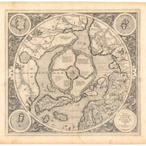
The last great map of the North Pole before it was reached.
[Arctic Exploration] Nord Polar Karte von V. v. Haardt.
$12,500
1 in stock
Description
The Most Comprehensive Wall Map of Arctic Exploration of the 19th Century – a must-have for explorers like Robert Peary, Frederick Cook, and Roald Amundsen.
Vincenz von Haardt’s 1898 map Nord Polar Karte von V. v. Haardt is a color lithographed wall map segmented and mounted on contemporary linen. Published a decade before the now famous contest between Robert Peary and Frederick Cook to reach the North Pole first (1909), the map meticulously traces the evolution of Arctic exploration across three centuries, from Martin Frobisher’s voyages in the late 16th century to contemporary expeditions of the late 19th century.
The map is a true explorers’ map, incorporating scientific data such as ice coverage, ocean currents, temperature variations, and magnetic fields, along with the portrayal of no less than 36 Arctic expedition routes. These included relatively recent attempts to reach the pole, such as Fridtjof Nansen and Hjalmar Johanson’s drive in 1895.
Other examples of how up-to-date Haardt’s map was are seen in the inclusion of the German Helgoland expedition to Spitzbergen and the Murman Coast or the naming of a new Arctic island as Victoria after Arnold Pike’s yacht. These events took place the summer of the same year our map was published, proving how cutting-edge this chart was. It is no surprise that Haardt’s Arctic and Antarctic maps were must-haves for people like Robert Peary, Frederick Cook, or, indeed, Roald Amundsen, who were all planning new polar expeditions at the time.
In unison, the expeditions and their dates confirm that the Arctic has been the target of exploratory expeditions since the 16th century and that the intensity with which mankind was driven to reach the pole only intensified and intensified during the 19th century. In many ways, one might describe Haardt’s wall map as the last cartographic pinnacle before the mystical North Pole was finally conquered.
Surrounding the main map, we find eight insets positioned in pairs (one larger, one smaller) in each corner. The insets provide a distinct subset of essential data. Moving clockwise around the map from the upper right corner we find the following thematic overlays: annual precipitation, isotherms (a line on a chart connecting equal points of temperature) in July, 2nd inclination magnetic conditions (Neumayers model used to calibrate instruments), isobars and dominant winds in July, isobars and prevailing winds in January, 1st inclination magnetic conditions (also Neumayer), isotherms in January, and isotherms lines for the entire year.
Context is Everything
The late 19th century marked a period of intense exploration fervor, particularly towards the Arctic regions. Much of this enthusiasm was driven by scientific curiosity, but nationalistic competition and the quest for great discoveries also played their part. The race to the North Pole, in particular, captured the imagination of the public and governments alike. Notable expeditions, such as those led by Fridtjof Nansen and Otto Sverdrup depicted on Haardt’s map, were not officially aiming for geographical achievement but rather for a deeper scientific understanding of the polar environment. When Nansen lent Roald Amundsen his expeditionary ship FRAM years later, it was on the strict condition that scientific knowledge of the ice sheets’ movements was more important than reaching the North Pole first. Amundsen made the promise while knowing full well that he intended to sail south and be the first to get to the South Pole instead.
Haardt’s map serves as a testament to humankind’s indomitable spirit of exploration, aligning well-known historical voyages and contemporary expeditions to the Arctic as part of the same dynamic. To those in the know, the incredible detail of the map also illustrates the 19th century’s crescendoing efforts to unravel the mysteries of the Arctic, thus suggesting that the pole itself was not far off.
Census
Haardt’s wall map of the Arctic was one of the finest achievements in 19th-century Arctic cartography. It was published in at least four iterations or states, the first and original wall map from 1895. Neatline’s example is from 1898 and is thus the second state. Additional states were published in 1899 and 1900, revealing how quickly new data was coming in. All states on the map are rare and sought after.
The OCLC lists only three libraries holding any of the four editions (Bibliotheque Nationale de France, Boston Public Library, and Marburg University in Germany). The 1898 edition (OCLC no.1037458348) is only found in the Norman B. Leventhal Map Center Collection at Boston Public Library.
Cartographer(s):
Condition Description
Color lithographed wall map segmented and mounted on contemporary linen. Excellent condition.
References