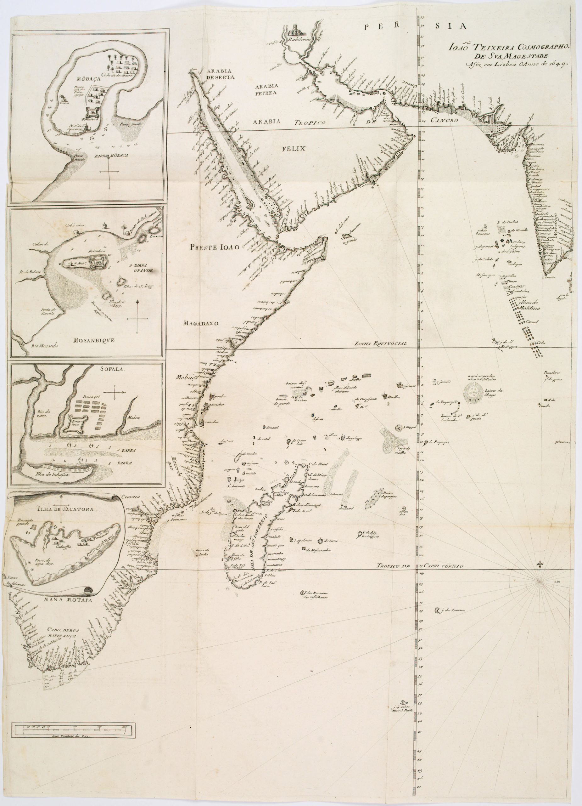
Carsten Niebuhr’s transformative map of the Red Sea.
Mare Rubrum seu Sinus Arabicus ad observationes maximam partem ab Auctore annis MDCCLXII et MDCCLXIII institutas delineatus a C. Niebuhr
Out of stock
Description
An attractive example of Carsten Niebuhr’s important 1774 map of the Red Sea, the product of the first European scientific expedition to Arabia, an early masterpiece of imperial cartography. This long map covers the red sea from Suez to the Gulf of Aden. It offers some maritime detail as well as exceptional notation of the port towns and cites to be found along the coast – particularly on the Arabian side.
Tibbetts notes that the foundation in the second half of the 17th century of the French Academie Royale des Sciences and the British Royal Society, as well as similar institutions in other capitals of Europe, led to the encouragement of travel and astronomical sciences and an increase in the accuracy of maps. The first cartographer of this new age was Guillaume De l’Isle, and with his maps there comes a new step in the cartographic representation of Arabia.
De l’Isle was the model for succeeding cartographers, including one of the most important of the 18th century, Jean Baptiste Bourguignon d’Anville. D’Anville’s 1751 map of Asia by showed the West how much about the interior of the Arabian Peninsula was unknown. To ameliorate this lack of information, the Royal Danish Arabia Expedition was launched.
Niebuhr compiled this map for the Danish expedition where he employed modern marine surveying techniques to produce the most accurate chart yet seen of the Red Sea. This chart was issued in Niebuhr’s 1774 book, published in Amsterdam after his return as the sole survivor of the expedition, Beschryving van Arabie.
Cartographer(s):
Carsten Niebuhr (1733-1815), a German mathematician, cartographer, and explorer in the service of Denmark, is renowned for his participation in the Royal Danish Arabia Expedition (1761-1767).
The Danish Arabia expedition was a Danish scientific expedition to Egypt, Arabia and Syria. Its principal goal was to elucidate the Old Testament with additional research goals concerned with natural history, geography and cartography. It had six members of whom only Carsten Niebuhr survived, returning to Denmark in 1767. The journey has been chronicled by the 20th century novelist, Thorkild Hansen, in his novel Arabia Felix.
Condition Description
Uneven margins. Strong impression.
References
OCLC 646117854. Harvard University, Pusey Library, MAP-LC G5687.R3 1772 .N5, Hollis: 011961735.
Tibbetts, G. R. Arabia in Early Maps. Ney York, NY: Oleander Maps, 1978.
![[With Extensive Contemporary Annotations] Ordnance Survey of the Peninsula of Sinai Made in 1868-9.](https://neatlinemaps.com/wp-content/uploads/2020/05/NL-00842_Thumbnail-300x300.jpg)
![[With Extensive Contemporary Annotations] Ordnance Survey of the Peninsula of Sinai Made in 1868-9.](https://neatlinemaps.com/wp-content/uploads/2020/05/NL-00842-scaled.jpg)
![[With Extensive Contemporary Annotations] Ordnance Survey of the Peninsula of Sinai Made in 1868-9.](https://neatlinemaps.com/wp-content/uploads/2020/05/NL-00842-scaled-300x300.jpg)