Detailed Northern Hemisphere map by Covens & Mortier with the Latest Voyages.
Hemisphere Septentrional pour voir plus distinctement Les Terres Arctiques…
Out of stock
Description
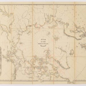
This map of the northern hemisphere was originally produced by Guillaume Delisle. This later edition has been updated and reissued by Covens & Mortier and is significantly rarer than the original edition of 1714 (as well as the derivatives published by De Leth and others).
California is shown as a peninsula, but with a dotted line that reflects the ongoing debate over its insularity. Across the Pacific, Japan (Niphon) is shown horizontally, a typical depiction for the time. To the northeast is an unfinished island called Terre de la Compagnie. A nearby note explains that the coast was discovered by Jean de Gama. This explanation actually elides two popular cartographic chimeras of the time. Juan de Gama, the grandson of Vasco de Gama, was a Portuguese navigator who was accused of illegal trading with the Spanish in the East Indies. Gama fled and sailed from Macau to Japan in the later sixteenth century. He then struck out east, across the Pacific, and supposedly saw lands in the North Pacific. These lands were initially shown as small islands on Portuguese charts, but they ballooned into a continent-sized landmass in later representations.
The text surrounding the hemisphere reveals one of the sources for this updated work, a map by Jean Kyrilow, Secretary of the Council of the Empire of Russia published in 1734. His map was used to provide a more complete outline of Kamchatka and northeast Russia than Delisle had included on his 1714 edition. A letter from a Dutch resident of St. Petersburg, a Mr. Swartz, is included in the lower portion of the border of this hemisphere.
Cartographer(s):
Covens & Mortier were a dynamic publishing duo working out of Amsterdam in the 18th century. Johannes Covens (1697-1774) was a Dutch geographic publisher based in the capital, whereas as Cornelis Mortier (1699-1783) was the Dutch-born son of a French cartographic publisher working out of Amsterdam.
Mortier’s father, Pierre Mortier the Elder (1661-1711) had in 1690 obtained the king’s privilege to distribute the works of French geographers in the Netherlands and subsequently settled in Amsterdam to build his business. Following his death, Cornelis took over his father’s business in 1719 and partnered up with his brother-in-law, Johannes Covens, a couple of years later. The pair soon began publishing maps and atlases under the name Covens & Mortier. Over the ensuing decades, the business passes from one generation to the next, effectively maintain the Covens & Mortier brand throughout the 18th century (but changing the name several times along the way).
As a result of Mortier Senior’s original privilege, the firm specialized in re-issuing iconic French geographers such as de l’Isles, Jaillot, and Sanson. But they did not limit themsleves to French products alone. In 1725, the duo reissued Frederik de Wit’s Atlas Maior from 1705, just as they issued their own pocket- and town atlases. They also purchased plates from other firms and mapmakers and modified them according to their commercial vision. Among the plates subsumed under the Covens & Mortier brand were those of Pieter van der Aa, which were acquired in 1730. This was also the heyday of the firm, when it supposedly owned the single largest collection of cartographic prints ever accumulated in the mapmaking city of Amsterdam.
Condition Description
Wear along edges and centerfold. Remnants of hanging tape on verso.
References
Related products
-
-
Add to cart


- Bird's-eye-views, Europe, Italy
Venetia.
- $3,500
-
-
-