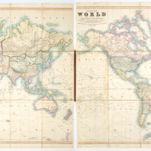
Gerald Valck’s world map in splendid original color.
Mappe-monde géo-hydrographique, ou description générale du globe terrestre et aquatique en deux plans hémisphères.
$3,500
In stock
Description
Gerald Valck’s world map, Mappe-monde géo-hydrographique, is a remarkable piece of cartographic history that offers a unique perspective on how the world was understood in the late 17th century.
This double hemisphere map, published by Valck around 1687, is a stunning example of the skill and craftsmanship of Dutch mapmakers. The map is rich in detail and was compiled with a pre-conceived aesthetic in mind. It drew inspiration from contemporary cartographers such as Nicolas Sanson and Alexis-Hubert Jaillot. Still, Valck also added a range of distinct characteristics of his own.
It is, in part, these features that make this map so desirable among collectors. Another aspect is the beauty of the surrounding imagery, which reveals that Valck was a gifted cartographer and a master engraver. However, What sets Valck’s map apart from its peers is the degree to which one can extrapolate our geographic understanding at this pivotal time in history.
Understanding the World in the 17th Century
The map depicts the two hemispheres, each meticulously adorned with geographic information and artistic embellishments. In the still largely uncharted Western Hemisphere, California is prominently shown as an island, reflecting the prevailing belief at the time. In the northeast of America we find one of the earliest depictions of the Great Lakes. By comparing Valck’s double hemisphere to other essential charts of the same era (e.g. John Speede’s map of the Americas), these have little to no indication of the Great Lakes. The first European cartographer to fully delineate and name all five of the Great Lakes was Nicholas Sanson in his 1656 map of New France. But Sanson also outlined and named two of the lakes in his trend-setting double hemisphere projection from 1651. It is, in other words, clear that Valck drew information from the best sources he could find.
In the Pacific Northwest, it becomes crystal clear how vague the geography of North America is at this stage. Early explorations up the California coastline provided some semi-mythical accounts, which were then intermixed with Ptolemaic conceptions of the world. In Valck’s map, a strangely elongated landmass entitled Iesso extends from America towards Asia and the Anian Strait but is seemingly detached from both continents. North of this land, we find nothing except a small note indicating the possibility of a Mer Glaciale. Iesso essentially extends from northern California to Japan, another crucial part of this map. The first Dutch vessel to reach Japan was in April of 1600, and since then, fruitful trade relations have been built between the merchants of Holland and the Tokugawa Shogunate.
Another exciting feature in the southern Pacific Ocean is the multiple indications of an Australian continent. Van Diemens Land (Tasmania) and New Zealand are outlined, following the discoveries of Abel Tasman in the 1640s. Slightly further north, a large island east of New Guinea is labeled Terre de Quir. This unidentified island is associated with the Solomons, which were first identified by the Spanish explorer Álvaro de Mendaña de Neira in 1568 and which had since been a fixed destination for European explorers and other soldiers of fortune.
The formative stage that world cartography was still in when these maps were compiled is reflected in the wraith-like presence of an enormous Antarctic continent, at the time mostly referred to as Terre Australe. This huge mythical southern continent was originally an adopted Ptolemaic concept that has persisted in European cartography until now.
Cartography as Art
One of the most striking aspects of this map is the ornate baroque scenes that adorn each of the four corners. These represent the four seasons of the year – joyous spring, industrious summer, bucolic autumn, and icy winter. These decorative elements add a unique aesthetic charm to the map. They are not only a testament to the artistry of the period but to the fact that the dividing line between cartography and art, indeed, was a fine one. Being some of the first of their kind on Dutch maps, the scenes became a hallmark of Gerald Valck’s later world maps, including his monumental eight-sheet Nova Totius Terrarum.
The fine engravings are part of what made Valck’s double hemisphere stand out from its peers. What makes Neatline’s example of this map stand out from other examples on the market is the impressively well-preserved and vivacious original color, making it an ideal addition to any collection dealing with the 17th century or the Golden Age of Dutch cartography.
Valck worked closely with other Dutch mapmakers and engravers, including Peter Schenk the Elder. Therefore, his map is more than just an exemplary representation of the age in which it was created: it is a testament to the heights achieved through collaborative effort.
In conclusion, Gerald Valck’s world map from 1687 is a splendid and highly decorative mappemonde that provides unique insight into how the world was understood in the late 17th century. Its distinctive cartographic features, artistic embellishments, and historical significance make Valck’s map a pinnacle in Dutch cartography.
Cartographer(s):
Gerard Valck (1652 – 1726) was a Dutch engraver, publisher, and cartographer. Born in Amsterdam, he was a student of Abraham Blooteling, with whom he spent several years in London honing his craft, especially by engraving portraits of English nobility. He was especially skilled at mezzotint engraving. Valck often frequently collaborated with his son, Leonardus, and brother-in-law, Peter Schenk the Elder, also a noted map engraver. Under Valck’s name, the group published multiple maps, globes, and atlases.
Condition Description
Great old color. Backed with verso repairs to tears at bottom and bottom-right. A couple spots of discoloration in title at top margin.
References
![[Ortelius & Hogenberg Atlas Factice]](https://neatlinemaps.com/wp-content/uploads/2023/03/NL-01678-leo-belgicus-3_thumbnail-300x300.jpg)