Fascinating Composite Dutch Atlas. With Frans Hogenberg’s very rare Germaniae Inferioris and Eytzinger’s Leo Belgicus. Bound in a unique double-folding format for travel.
[Ortelius & Hogenberg Atlas Factice]
$28,000
1 in stock
Description
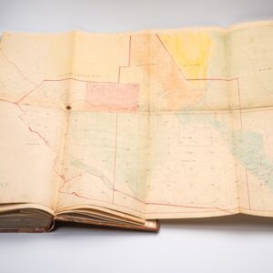
This is a unique Atlas Factice created around the year 1600. Its compiler arranged it in a slim and tall folio format, with each map double-folded to fit inside. This rare and unusual format was designed to make the atlas compact and, above all, portable. Bound in vellum, the focus is on Western Europe, with the Low Countries and surrounding regions represented in particular detail.
The atlas includes some of the finest maps of the period. It opens with Ortelius’ world map in its first state (identified by the riveted repair in the plate), which was published in the original 1570 edition of Theatrum Orbis Terrarum. The rarest map in the atlas is Frans Hogenberg’s Germaniae Inferioris Omnium Accuratissima Delineatio (1578), which retains its original coloring and is among the finest 16th-century charts of the Greater Netherlands (with only ten known institutional examples). Another scarce map is Michael Eytzinger and Frans Hogenberg’s zoomorphic map of the Low Countries in the shape of a ‘rampant lion,’ a common symbol for bravery, honor, strength, and royalty. Eytzinger first drew the Low Countries in this manner (1583), making this one of the earliest examples of an explicitly political map. Known as the Leo Belgicus, this second state of the map was issued from Hogenberg’s workshop in Cologne in 1588.
Four key features characterize this atlas:
1. The Dutch struggle for independence: In 1549, the Dutch and Flemish fiefs fell under Philip II of Spain, who consolidated power to exercise direct rule. This included a harsh countenance of Calvinist and Protestant sentiments, which led to the outbreak of the Eighty Years’ War in 1568. In January 1579, the seven northern provinces declared independence from Spain and formed the first Dutch Republic.
The Dutch Revolt was part of a much wider European conflict that entailed the French Wars of Religion, the Nine Years War in Ireland, and the Anglo-Spanish War (1585-1604). Treaties between 1598 and 1604 stifled all of these devastating conflicts. The Treaty of London (1604) was crucial in that it restored the status quo between England and Spain. It allowed Isabella Clara Eugenia (daughter of Phillip II) and her husband Archduke Albert VII of Austria (and Spain’s Governor General) to instigate a period of much-needed peace in the Netherlands. Our atlas was compiled within this context of diplomacy and negotiation. This is confirmed by the three cartographers used and by carefully selecting and ordering the maps inside the atlas.
2. Luxembourg as a place of prominence: A clue to the origin of this atlas is the order in which the individual maps were placed inside (see list below). The first three maps are world, regional, and symbolic. The world map was a standard component in any good atlas of the era. The regional map, Hogenberg’s Greater Netherlands, follows naturally from the opening world map. The third map, Eytzinger’s Rampant Lion, reflects its popularity and the political context in which our atlas was created.
The fourth map is Ortelius’ map of the Duchy of Luxembourg. Its position in the atlas reflects prominence and suggests that the compiler had some connection to this area. Jacob Surhon prepared this map based on a manuscript map of Luxembourg that he had compiled for Charles V in 1551. Surhon’s original map was not initially printed for security reasons. It was only in 1579, when Antwerp, for a short time, was independent of Spanish rule, that Ortelius was able to adopt the map for publication in his atlas. Luxembourg remained in the Catholic camp throughout the Eighty Years War, indicating that the atlas’ patron and owner also belonged to this side.
3. An atlas designed for portability: The oblong format of the folio is highly unusual and would not have been a standard format. The most logical reason to create this format is portability, suggesting this document needed to travel with its owner. Considering the expense of compiling it and its elegant combination of geographical focus and comprehensive coverage, the ideal context for such an atlas would have been the many diplomatic negotiations senior members of the various privy councils undertook in the early 17th century. In this light, we note that despite the atlas’ focus on the Greater Netherlands, it also included dedicated map sheets for England, France, and Spain.
4. A crested frontispiece: The vellum binding includes the tantalizing but faded remains of an inked coat of arms. The crest is mostly illegible, but several features can be made out. Firstly, the blazon centers on an elaborate oval or cartouche, surrounded by what appears to be extensive ornamentation at the bottom and on both flanks. A central medallion or shield carries an image that cannot be identified. Hovering above the prominent crest, we can make out what appears to be a tall, broad-rimmed hat. While we have not identified any feature like that in the heraldry of Luxembourg’s noble families, its characteristic shape is recognizable to us from the watermarks of earlier maps and atlases – particularly the printed matter of Niccolo Tedesco.
This symbol is often referred to as a Bishop’s hat. Its identification confirms that at least one owner of the atlas was Catholic and associated with a diocese in the southern half of the Spanish Netherlands. Luxembourg did not have its own diocese in the early 17th century but fell intermittently under the Archdioceses of Trier and Liege. Neighboring dioceses, such as Cambrai and Arras, did, however, have crests that were crowned by precisely such a Bishop’s Hat.
Our Interpretation
While the original patron of this marvelous atlas cannot be identified unequivocally, we hold that the combination of the above four characteristics points to one man in particular: Jean Richardot.
Richardot was a prominent politician and diplomat operating in this region. He had at first sided with William of Oranje in his initial struggle to throw off the yoke of Spanish Rule. While this sympathy did not last, Richardot served on the Privy Council of Archduke Matthias, the Dutch rebels’ Governor-General, for a time. When Richardot returned to the Catholic side shortly after, the new Governor-General of the Spanish Netherlands, Alexander Farnese, appointed him president of the Council of Artois (1581). In this capacity, Richardot became a key figure in Spain’s many treaty
negotiations. In 1598, he led the delegation that negotiated the Peace of Vervins between Philip II and Henry IV of France. Some years later, in 1604, he was a vital part of the Spanish delegation sent to London in 1604 to negotiate peace with the English. At the time, Richardot was President of the Brussels Privy Council and thus served under the direct authority of Archduke Albert, governor-general of the Spanish Netherlands. From February until August 1608, Richardot was the Habsburg delegation’s chief negotiator at the conference in The Hague. Richardot was thus not only a critical diplomatic figure who had supported both sides of the Dutch conflict, but he traveled extensively on behalf of his Catholic patrons to hammer out agreements that almost always were manifested in new territorial divisions. Who better than to commission and own an atlas such as this?
While Richardot is a good candidate, he was never directly associated with a diocese that could explain the crest on the front. His son, Jean Richardot the Younger, nevertheless did have this connection, being appointed the bishop of Arras in 1602. In August 1609, Richardot the Elder traveled to France to assure Henry IV of Albert’s neutrality in a number of contentious matters. On the return journey, Richardot fell ill and stopped to rest at his son’s episcopal residence in Arras. He died shortly after arriving. This documented event explains the crest. As a valuable diplomatic aid in negotiations, the atlas would have been with Richardot when he arrived in Arras. After his death, this worn but valuable tome was passed to his son, who subsequently had it marked in ink with the crest of his diocese.
Later that year, Richardot the Younger was promoted to bishop of the larger Archdiocese of Cambrai. Both the crest of the Diocese of Arras and that of the Archdiocese of Cambrai include a bishop’s hat hovering above the main shield of the crest.
Complete list of maps:
1. Abraham Ortelius. Typus Orbis Terrarum. [World]. Old hand-color. First plate with riveted crack repair, circa 1575.
2. Frans Hogenberg. Germaniae Inferioris Omnium Accuratissima Delineatio. [Belgium, Netherlands, Germany]. Old hand-color. Cologne, 1578. Schilder, Monumenta Cartographica Neerlandica vol. I, p. 45-46; H.A.M. Van der Heijden, The Oldest Maps of the Netherlands, map 20, pages 143-45. Fewer than ten institutional copies traced.
3. Michael Aitzinger; and Frans Hogenberg. Leo Belgicus. [Zoomorphic map of Belgium and the Netherlands]. Cologne, 1588. Van der Heijden, map 27, pages 158-160, second state.
4. Ortelius. Lutzenburgensis Ducatus Veriss Descript. [Luxembourg and southern Belgium]. Partial hand-color.
5. Ortelius. Brabantiae Germaniae Inferioris Nobilissimae Provinciae Descriptio. [Duchy of Brabant, i.e., parts of Belgium and the Netherlands to encompass Rotterdam, Antwerp, and the upper Meuse River]. Partial hand-color.
6. Ortelius. Nobilis Hannoniae Comitatus Descrip. [Hainaut region of southern Belgium].
7. Ortelius. Namurcum Comitatus. [Namur, central Belgium].
8. Ortelius. Atrebatum Regionis Vera Descriptio. [Northern tip of the Hauts-de-France].
9. Ortelius. Oost Ende West Vrieslandts Beschryvinghe Utriusque Frisiorum Regionis Noviss Descriptio. [Friesland, Netherlands]. Dutch text on verso (1571 or 1573). 10. Ortelius. Leodiensis Dioecesis Typus. [Central Belgium].
11. Ortelius. Lorraine, Lotharingiae Nova Descriptio. [Lorraine region, northeast France].
12. Frans Hogenberg. Galliae Regni Potentis, Nova Descriptio. [France]. Cologne, 1583.
13. Ortelius. Regni Hispaniae Post Omnium Editiones Locuplessima Descriptio. [Spain and Portugal].
14. Ortelius. Deutschlanndt. Germaniae Typus. [Holy Roman Empire]. 15. Ortelius. Gelriae, Cliuiae, Finitimorumque Locorum Verissima Descriptio. [Gelderland and northwest Germany].
16. Ortelius. Angliae, Scotiae, et Hiberniae, Sive Britannicar: Insularum Descriptio. [British Isles].
17. Ortelius [but J.B. Vrients]; after Christopher Saxton. Anglia Regnum. [England and Wales].
Cartographer(s):
Abraham Ortelius (1527-1598) was born in Antwerp to Flemish parents in 1527. After studying Greek, Latin, and mathematics, he and his sister set up shop as book dealers and a ‘painter of maps.’ In his heart, Ortelius was, nevertheless, first and foremost a historian. He believed geography was the ‘eye of history,’ which explains why he collected maps and historical documents with such passion. Ortelius traveled widely in pursuit of his interests, building contacts with mapmakers and literati all over the European continent.
Ortelius reached a turning point in his career in 1564 with the publication of a World Map in eight sheets, of which only a single copy survives. In 1570, he published a comprehensive collection of maps titled Theatrum orbis terrarum (Theatre of the World). The Theatrum is conventionally considered the first modern-style atlas. It was compiled by collecting maps and charts from colleagues across the continent, which Ortelius then had engraved in a uniform size and style. The engraver for most of the maps in Theatrum was none other than the famous Frans Hogenberg, who also served as the main engraver for the 16th-century urban atlas Civitates Orbis Terrarum, published with Georg Braun in 1572.
Hogenberg’s re-drawn and standardized maps formed the basis of the first atlas in history (even though it was Mercator who was the first to use the term a few decades later). Unlike many of his contemporaries, Ortelius noted his sources openly and in the first edition, acknowledged no less than eighty-seven different European cartographers. This ‘catalogus auctorum tabularum geographicum‘ is one of the major innovations of his atlas. The list of contributing mapmakers was kept up-to-date for decades after Ortelius’ death. In the first edition of 1570, this list included 87 names, whereas the posthumous edition of 1603 contained no less than 183 names.
While compiled by Abraham Ortelius in the manner described above, the Theatrum was first printed by Gielis Coppens van Diest, an Antwerp printer experienced with cosmographical books. Van Diest was succeeded by his son Anthonis in 1573, who in turn was followed by Gillis van den Rade, who printed the 1575 edition of Ortelius’ atlas. From 1579, Christoffel Plantin took over, and his successors continued to print Theatrum until Ortelius’ heirs sold the copperplates and the publication rights to Jan Baptist Vrients in 1601. In 1612, shortly after Vrients’s death, the copperplates passed to the Moretus brothers.
Frans HogenbergFrans Hogenberg (1535–1590) was a Flemish painter, engraver, and mapmaker.
Condition Description
Seventeen folded double-page engraved maps; wide margined with blank versos. Contemporary vellum cover, stained but sound, faded crest to upper cover. Expert restorations to strengthen the maps and carried out to archival standards.
References
![Reconnaissance of the Western Coast of the United States from San Francisco to Umpquah River [&] Voyages of Discovery and Exploration on the Northwest Coast of America from 1539 to 1603.](https://neatlinemaps.com/wp-content/uploads/2021/01/NL-00878_Thumbnail-300x300.jpg)