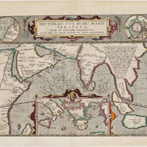
Athanasius Kircher’s pioneering map of the Moon.
Typus Corporis Lunaris Panselini [First edition]
Out of stock
Description
One of the first attempts to map a planetary body in any detail.
Predates the seminal Cassini map by more than a decade.
This superb engraving from the first edition of Athanasius Kircher’s Late Renaissance work, the Mundus Subterraneus, constitutes one of the first serious attempts at drawing an observation-based map of the moon. It is as rich in detail as it is strange in appearance. Kircher had conducted extensive astronomical studies of the lunar surface and concocted a series of theories on its composition and geography.
The Mundus Subterraneus was the first scientific work to describe the Earth’s inner workings: an encyclopedic 12-book tome brimming with explanatory diagrams and maps. Among the most famous and desirable images are bold attempts to map the sun and the moon in considerable detail.
In this highly original attempt at lunar mapping, Kircher depicts a range of features on the visible surface, which he also describes in the associated text of the book. Like Cassini’s famous map of the moon from 1679, Kircher’s map does not identify or label any features on the map itself. But unlike the realism of Cassini’s depiction, the features on Kircher’s map are amorphous and strange, bordering on the fantastical. Large amoeba-like fields represent enormous depressions, gigantic craters with star lines emanating from them, and mountain ranges of continental scope.
That this is indeed the first state of the map is confirmed by the fact that the engraving does not contain the large title banner borne by putti on clouds, which was added to a more widely distributed edition from 1669. Our edition of this lunar map is thus highly collectible.
Ultimately, this map is a product of Renaissance curiosity. But at the same time, it also heralds the more systematic scientific and philosophical approaches that would define the new Age of Enlightenment.
Context is Everything
Athanasius Kircher was one of the great polymaths of the 17th century. He was a contemporary of Galileo and possessed a similar curiosity and thirst for knowledge, although he remained in the good graces of the Church throughout his life. As a Jesuit priest and scholar, Kircher was a learned man who had leeway to conduct a range of important experiments and observations during his lifetime. His true awakening, however, came after a visit to southern Italy in 1637-38.
The volcanic activity he witnessed in Italy both fascinated and frightened Kircher to such an extent that he built his most famous work, a comprehensive survey of the subterranean world, on the observations made during this trip. He expanded these with earlier datasets and a plethora of wonderful explanatory illustrations and maps.
The Mundus Subterraneus marks the first serious effort to describe the physical makeup of the Earth, proposing theories (sometimes fantastical) within the fields of physics, geography, geology, and chemistry. Among the hypotheses that Kircher put forward in this work was the existence of a vast network of underground springs, reservoirs, and lakes. He was also the first to suggest that subterranean temperatures increase directly in proportion to depth.
In addition to speculating on the geological makeup of the Earth, the Mundus Subterraneus proposed the existence of underground rivers of fire and strange inhabitants in the planet’s interior. The book’s complexity was underlined by its endeavor to link the subterranean phenomena with observable features on the Earth’s surface (e.g. currents and meteorology), as well as with celestial phenomena like solar and lunar eclipses. Kircher then used established ideas about the Earth to create hypothetical depictions of the sun and the moon.
Kircher lived in a world where anything that could be mapped could be understood. Indeed, mapping often proved a vital part of the process that led to understanding. In the 17th century, such notions drove men to explore the Earth’s furthest and most inhospitable regions, just as it drove our author to lower himself into the crater of Vesuvius shortly after an eruption.
Cartographer(s):
Athanasius Kircher (1601-1680) was a Jesuit priest and scholar who gathered knowledge from around the world through Jesuit missionaries and disseminated it in a more compelling and effective form. In many ways, Kircher was one of the last great Renaissance thinkers. In addition to his explorations of the Earth’s interior, he conducted experiments using bioluminescence as a light source and was the first known maker of the Aeolian harp.
Kircher assembled one of the first natural history collections in the world, wrote more than forty books, and left over 2000 manuscripts behind. Within this oeuvre was a range of ground-breaking (and often highly speculative) maps, including the first depiction of the Pacific Ring of Fire and the first map to show oceanic currents on a global scale.
Jan JanssoniusJohannes Janssonius (1588 – 1664; born Jan Janszoon, also Jan Jansson) was a Dutch cartographer and publisher who lived and worked in Amsterdam in the 17th century. Janssonius was born in Arnhem, the son of Jan Janszoon the Elder, a publisher and bookseller. In 1612 he married Elisabeth de Hondt, the daughter of Jodocus Hondius. He produced his first maps in 1616 of France and Italy.
In the 1630s, Janssonius formed a partnership with his brother-in-law Henricus Hondius; they published atlases as Mercator/Hondius/Janssonius. Under the leadership of Janssonius, the Hondius Atlas was steadily enlarged. After Janssonius’s death, the publishing company was continued by his son-in-law, Johannes van Waesbergen. The London bookseller Moses Pitt attempted publication of the Atlas Major in English but ran out of resources after the fourth volume in 1683.
Condition Description
Very good. Fold lines visible. Wear along upper edge.
References
![Das Jahr der Kirche [The Year of the Church]](https://neatlinemaps.com/wp-content/uploads/2022/09/NL-01244_thumbnail-1-300x300.jpg)
![Das Jahr der Kirche [The Year of the Church]](https://neatlinemaps.com/wp-content/uploads/2022/09/NL-01244_thumbnail-scaled.jpg)
![Das Jahr der Kirche [The Year of the Church]](https://neatlinemaps.com/wp-content/uploads/2022/09/NL-01244_thumbnail-scaled-300x300.jpg)