Nicolas de Fer’s seminal map of the Americas.
L’Amerique meridionale et septentrionale
$1,800
1 in stock
Description
Reissued multiple times and copied prodigiously for decades, Nicolas de Fer’s map of the Americas stood as the cartographic pinnacle of French depictions of the New World. Here offered in the hotly debated 1727 edition.
At the dawn of the 18th century, eminent French cartographer Nicolas de Fer published one of the most important maps of the Americas in his career. Due both to its popularity but also to its sheer quality and accuracy as a continental map, the map was re-issued many times in different states (including in copied versions by cartographers Guillaume Danet, Jacques-Francois Benard, and the Napolitan mapmaker Paolo Petrini). The original map was compiled as a large-scale wall map, but De Fer soon had it re-engraved by Hendrick van Loon to fit the folio dimensions that were common in the large commercial atlases that were popular at the time. One of the reasons this map became so popular was that it retained the vast majority of the wall map’s many details and general quality.
Among the many notable features of this map, we find the depiction of California as an island, complete with coastal toponyms along the west coast. The map also constitutes one of the earliest full configurations of the Great Lakes area, the exploration of which was dominated by the French. Their presence here, and De Fer’s access to information coming out of Nouvelle France, is not only reflected in the cartographic accuracy and detail, but also descriptive annotations and the abundance of place names. Another region explored by the French was the delta and lower course of the Mississippi River, which Sieur de la Salle thoroughly documented in his 1682 expedition to the Gulf.
Further north, we see elements added to the Mississippi, including several tributaries that extend from the Rockies and into the great continental river. Despite being well informed of the geography, De Fer places the delta considerably further west than its actual location. Rather than an error in mapping, this constituted a conscious political move – a cartographic land grab of sorts in that it extended French dominion deep into Spanish territory. This ambition, which was related to the rise of the Bourbons over the Habsburgs in Spain, is further reflected in the old-color delineation of Nouvelle France on the map.
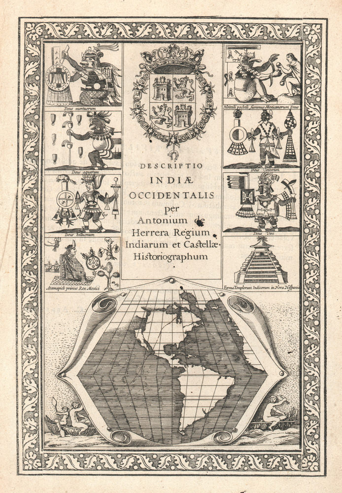
To the south, we find an enlarged South America where territorial subdivisions have begun manifesting themselves as clearly and as politically loaded as in North America. Finally, we note the presence of several finely engraved cartouches, which are surrounded by elaborate vignettes of Native American peoples, indigenous flora and fauna, and scenes of daily life.
Nicolas de Fer’s map was initially published in his Introduction a la Geographie Avec une Description Historique sur toutes les Parties de la Terre. Par N. DE FER, Géographe de sa Majesté catholique, & de Monseigneur le Dauphin (Paris, 1708), but the popularity of this map caused it to be re-issued in several unrecorded states, as well as in the form of post-humous reproductions by other cartographers. Even today, there is some debate as to the order and identification of the different states. The two leading authorities, Burden and McLaughlin, substantially disagree on how to classify them. In his 1972 book on maps depicting California as an island, John Leighly notes a state with a date of 1727. One of the world’s leading authorities on historical maps, Phillip Burden, has since dismissed this as an erroneous reading, but our example also includes this date in the cartographer’s cartouche in the lower right corner of the map.
Cartographer(s):
Nicolas De Fer (1646–1720) was a French cartographer and geographer who also worked as an engraver and publisher. He was renowned for his massive output and his pleasant visual designs. He was the son of a Parisian cartographer and began apprenticing at an early age. By twelve, however, he shifted his apprenticeship to the closely associated field of engraving – a move his father no doubt encouraged, as it might enhance his competitive position on the market with his son as a trained engraver.
De Fer’s father died in 1673, but Nicolas did not take over the company until 1687, at which point it had been virtually run into the ground. Nevertheless, Nicolas had a knack for business and soon turned things around. By 1690, he was so successful that he won employment as the official geographer to Louis, Le Grand Dauphin of France, and son of the reigning French king, Louis XIV. Soon after, with support from the Spanish and French courts, De Fer was appointed the official geographer for King Louis XIV. In 1720, shortly before his death, he was even appointed royal geographer to Philip V, king of Spain.
De Fer’s popularity in the Bourbon royal circles was primarily due to his appreciation of the propagandistic effects of strategic cartography. But no doubt his keen sense of aesthetics helped as well. Whatever the case, his maps were hugely popular, well-funded, and widely distributed. He was impressively productive, publishing over 600 sheets from his atelier and covering everything from town plans to world maps. Many of his maps rode the political conjunctures of the age. Hardly would a territory have been won or surrendered before De Fer’s atelier was working on a map delineating the new realities.
Condition Description
Original outline color. Some wear along the centerfold and in the margins.
References
Burden II 753; McLaughlin 127; Tooley No. 60/pl.51; Leighly 105 & 161 ; Wagner (NW) 482.